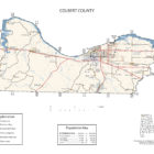
Colbert County Alabama
Colbert County Alabama
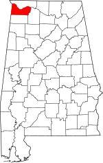 Colbert County Alabama is a beautiful area with a deep history dating back to the Cherokee and Chickasaw Indians and the early French traders around 1715. These early residents and settlers were attracted by the Tennessee River; the section in Colbert County earned the name “Muscle Shoals” because of the strength of the river in this area and the several different species of mussels. Colbert County has a population of 54,428. The county seat is Tuscumbia Alabama.
Colbert County gets its name is in honor of brothers George and Levi Colbert, Chickasaw Indian chiefs.

It is also the location of Ivy Green, the birthplace of noted author Helen Keller. Colbert County is also home of the towns Sheffield and Muscle Shoals where many popular musicians such as Aretha Franklin and the Rolling Stones recorded music. Colbert County is the home of the Key Underwood Coon Dog Memorial Graveyard established in 1937.
Colbert County Alabama Cities
Muscle Shoals Alabama
Muscle Shoals is the largest city in Colbert County, Alabama, United States. It is located along the Tennessee River in the northern part of the state and, as of the 2010 census, the population of Muscle Shoals was 13,146. The estimated population in 2018 was 14,263.
Sheffield Alabama
Sheffield is a city in Colbert County, Alabama, United States, and is included in the Shoals metropolitan area. As of the 2010 census, the population of the city was 9,039.
Tuscumbia Alabama
Tuscumbia is a city in and the county seat of Colbert County. As of the 2010 census, the population was 8,423. The city is part of The Shoals metropolitan area.
Colbert County Alabama Towns
Cherokee Alabama
Cherokee is a town in west Colbert County. It is part of the Florence–Muscle Shoals metropolitan area, known as “The Shoals”. As of the 2010 census, the population of the town was 1,048.
Leighton Alabama
Leighton is a town in Colbert County. It is part of the Florence – Muscle Shoals Metropolitan Statistical Area known as “The Shoals”. At the 2010 census the population was 729. The first settlers in what is now Leighton arrived in the early 1810s. The community was initially known as “Crossroads” for its location at the intersection of two early stage coach roads. The name was later changed to”Leighton” for town’s first postmaster, the Reverend William Leigh. The town developed as a cotton shipping center in the 1830s after the Tuscumbia, Courtland and Decatur Railroad constructed a railroad line through the area. Leighton incorporated in 1890.
Source: Wikipedia contributors, “Leighton, Alabama,” Wikipedia, The Free Encyclopedia
Littleville Alabama
Littleville is a town located on the southern border of Colbert County, at 34°35′27″N 87°40′32″W (34.590933, -87.675599), Alabama, and extends into Franklin County. It is part of the Florence – Muscle Shoals Metropolitan Statistical Area known as “The Shoals”. As of the 2010 census, the population of the town was 1,011.
Littleville gets its name from Benjamin F. Little, one of the early settlers in the area who built a store near the railroad.
Littleville Al Zip Code
35654, 35674
Littleville AL Police Department
Colbert County Alabama Communities
Allsboro Alabama

Allsboro is a populated place in Colbert County. This unincorporated community is located in the far western area of the county, about 9 miles southwest of the town of Cherokee, near the Mississippi state border.
Barton Alabama
Barton, also known as Barton Station, Barton Depot, or Barton’s, is an unincorporated community located in western Colbert County, Alabama, United States. It is about ten miles west of the county seat of Tuscumbia, and just south of Tennessee River.
Buzzard Roost Alabama
Buzzard Roost is an unincorporated community in Colbert County. Buzzard Roost had a post office in the 1850s, but it no longer exists.
Ford City Alabama
Ford City is an unincorporated community in Colbert County. Ford City is located at the junction of County Highways 40 and 48, 8.4 miles east-northeast of Muscle Shoals.
Hatton Alabama
Hatton is an unincorporated community in Colbert County. Hatton is located on Alabama State Route 184, 10.4 miles east of Muscle Shoals.
Maud Alabama
Maud is an unincorporated community in Colbert County, Alabama, United States, located 11 miles southwest of Cherokee.
Mountain Mills Alabama
Mountain Mills is an unincorporated community in Colbert County. A short and interesting history of Mountain Mills is posted on Wikipedia.
Nitrate City Alabama
Nitrate City is an unincorporated community in Colbert County.
World’s Biggest Nitrate Plant article
Nitrate City Volunteer Fire Department
Spring Valley Alabama
Village Number 1 Alabama
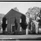
Photo Credit: Colbert County Courthouse by Dailynetworks
Colbert County Historical Destinations
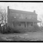
Barton Hall – Cherokee Alabama
Barton Hall, also known as the Cunningham Plantation, is an antebellum plantation house near present-day Cherokee, Alabama. Built in 1840, it is a stylistically rare example of Greek Revival architecture in Alabama, with elements from the late Federal period. The house was designated a National Historic Landmark in 1973 for its architecture.
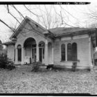
Belle Mont Mansion – Tuscumbia Alabama
FAME Recording Studio – Muscle Shoals Alabama
Ivy Green, Helen Keller’s Birthplace – Tuscumbia Alabama
Key Underwood Coon Dog Memorial Cemetery – Cherokee Alabama
LaGrange College Site Park – Leighton Alabama
Muscle Shoals Sound Studio – She!eld Alabama
Alabama Music Hall of Fame –Tuscumbia Alabama
Colbert County Alabama Ghost Towns
Bishop Alabama
Latitude N34 39.947′ Longitude W88 06.841′
34°39’56.8″N 88°06’50.5″W
34.665783, -88.114017
Colberts Ferry Alabama
Colberts Ferry (historical) is a cultural feature (crossing) in Colbert County.
Latitude N34 50.785′ Longitude W87 56.413′
34°50’47.1″N 87°56’24.8″W
34.846417, -87.940217
Hunter Alabama
Latitude N34 38.469′ Longitude W87 36.753′
34°38’28.1″N 87°36’45.2″W
34.641150, -87.612550
Margerum Alabama
Latitude N34 46.026′ Longitude W88 04.103′
34°46’01.6″N 88°04’06.2″W
34.767100, -88.068383
Maud Alabama
Latitude N34 38.584′ Longitude W88 06.593′
34°38’35.0″N 88°06’35.6″W
34.643067, -88.109883
Pride Alabama
Latitude N34 43.417′ Longitude W87 49.234′
34°43’25.0″N 87°49’14.0″W
34.723617, -87.820567
Rock Creek Alabama
Latitude N34 35.800′ Longitude W87 55.005′
34°35’48.0″N 87°55’00.3″W
34.596667, -87.916750
COLBERT COUNTY ARCHEOLOGICAL INVESTIGATIONS
Newsom Springs
Numerous caves, most of them small, are reported in the county. The best known is at Newsom Springs, 8 miles south of Barton, Alabama on the Southern Railway. It is locally known as the “three-story cave.” The lower “story” is a cave from which water always flows. The second “story” is directly above the first. The two have no connection, unless far back in the hill. The floor of the upper cave is mostly rock. It is now fitted up by some people in the neighborhood as a camping place, where they spend a part of each summer. The third “story” is an excavation for a cellar under a house recently erected.
Murrell’s Cave
Tradition has it that this cave was one of the hiding places of a famous desperado and horse thief whose gang operated over all this country in early days. The only entry is by means of a ladder in a narrow crevice 20 feet deep. The place may have been a refuge, but never a residence. It is one-fourth of a mile from Bear Creek, not far above the mouth.
Two other holes or crevices within a few hundred yards, difficult to crawl through, reach small caves. Possibly all these are connected.
Bat Cave
One-fourth of a mile from Murrell’s Cave is a small cavern, the roof not more than 4 feet above the floor. It has been inhabited from time immemorial by myriads of bats. Several tons of guano have been taken out for fertilizing purposes, but no evidence has been discovered that it was ever a habitation for humans.
Pride’s Cave
In the river bluff a mile from Pride Station is a cave in which a fisherman has made his home for several years. There is a rather thin deposit of earth on the floor which may have recently accumulated.
Cheatham’s Ferry
Near the landing some boys, while hunting a few years ago, discovered a stone wall across the mouth of a small cave. Tearing it away, they found within some human bones, flints, pipes, including one “with a lot of stem holes,” and fragments of pottery. All these were on top of the earth or only a few inches below it. Various excavators or relic hunters have failed to find anything more. The cavity is quite small and difficult to reach, and is undoubtedly a burial place for modern Indians.
On both sides of the river here are immense shell heaps. The shell is mingled with earth near the top, but below 2 or 3 feet the mass is of clean shell to a depth, as exposed by the river, of at least 10 feet. The bottom of the deposit is not visible, being concealed by mud piled against it in high water. The old ferryman says it is 20 feet deep. Although the shell piles are built up higher than the bottom lands to the rear or on either side, they are submerged several feet in great freshets. It is impossible to explain this fact otherwise than by the assumption that the bed of the river has been elevated in recent times, although there are no other indications apparent that such is the case.
Sheffields
In the river bluff 2 miles above the Sheffield end of the railway bridge is a crevice or joint which has been widened to 10 feet at the outlet by water percolating from the top of the bluff. When discovered, a rock wall was piled across it near the entrance. Behind this human bones were found with “pieces of pottery and other things.” They were close to the surface. Subsequent explorations have revealed nothing below them. It is plainly a burial cave for Indians. The river now reaches at flood tide to within 10 feet of the floor. The earth covering the bones may have washed over them, as there is some evidence farther back in the crevice that surface material is still carried in from the rear, in very small amounts, during rainy seasons.
Rock Shelters
Several very large rock houses exist on the southern slope of the hill or “mountain” lying a mile to 2 miles south of Pride, 7 miles west of Tuscumbia, Alabama. Water drips from the roofs, keeping the floors wet all the year and collecting in pools to which stock resorts when the little creeks or brooks in the ravines become dry.
It is useless to search in this part of Alabama for caves presenting indications that they may have been habitable, or the reverse, in ages past. The native rock is a cherty or flinty limestone, crumbling easily, and readily susceptible to changes from atmospheric influences, and especially so to the action of water. New subterranean channels are continually developing, with consequent changes in the interior of any cavern near them.
Colbert County Weblinks
Littleville, Alabama 35654
Chief Kelly Aday
1340 Alabama Av, Muscle Shoals, Alabama 35661
Email: ncfire972@aol.com
Cell: 256-710-1901 Fax: 256-446-9022