Erie was once a vibrant town of 1,500 and county seat of Greene County, Alabama – now nothing remains and it is in Hale County
The post Erie Alabama: An Alabama Ghost Town appeared first on Digital Alabama.
]]>Erie Alabama was formed as the first municipality in the county in 1820. Erie, Alabama was located near today’s Sawyerville, Alabama in Hale County about a mile above old Lock 6 and 11 miles west of Greensboro, Alabama. The town spread over about 22 acres and housed quite a few business establishments. Nothing stands today. Erie was the also the first county seat of Greene County from 1819-to 1839 and has been part of Hale County since 1867. It was located on the East bank of the Black Warrior River about 11 miles west of Greensboro.
Erie Alabama History
According to the history of Greene County, Erie was located on the bank of the Black Warrior River in present day Hale County. It was a thriving town with stores, shops, a hotel, and newspaper. Copies of the local paper, The Democrat, are archived at the courthouse probate office in Greene County, Alabamaa.
Sometime in the late 1830’s or so, a sick man was taken from a steamship at Erie to be nursed back to health. He had Yellow fever and soon an epidmeic spread throughout Erie. That, along with the fact that the town had a poor water source ended the town. Most residents moved to Eutaw, Alabama just across the river and to the Greensboro, Alabama areas.
The Erie cemetery can be found by traveling County Road 15 in Hale County, AL to Erie Road. The cemetery is on the Left before you reach Mason Bend Road.
According to Roland Monette (descendent of Elizabeth Monnette family) in a posting to Genforum on 9/3/2002:
I have the old town plat, with last changes in 1910 by my great uncle Samiel Jackson “Jack” Monette who owned the entire town site until his death there in 1915. It then passed to his fiance, Miss Octavia Sledge who married Harvey Poellnitz; they disassembled the original old homestead of Rev James and Rachel Monett in 1946. In 1950’s the town site and 580 surrounding acres was bought by my late friend Charles Parnell. I helped maintain the old burying ground there for many years, and often took people back there who came looking for their ancestral roots, but I left in mid 80’s and moved to Europe. My family still owns the old Monette lands near Erie. I have all the old timer stories of Erie’s settlement mostly by Tennesseeans (Monett, McGee, Sullivan…) and Carolinians (including Phares and McAlpin).

Erie Alabama: An Alabama Ghost Town
For additional articles, visit the Alabama Ghost Towns Index
The post Erie Alabama: An Alabama Ghost Town appeared first on Digital Alabama.
]]>The post Greene County Alabama appeared first on Digital Alabama.
]]>Return To Alabama County Index
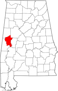
Greene County Alabama Map
Greene County Alabama population is 9,045. making it the least populous county in Alabama. Its county seat is Eutaw, Alabama.
Greene County was created by an act of the Alabama on December 13, 1819, from lands ceded to the federal government by the Choctaw Indian Cession of 1816. The county was named for Revolutionary War hero Nathaniel Greene, and the county seat, Eutaw, was named for the Battle of Eutaw Springs, in which Greene led his troops in the recapture of Charleston, South Carolina, from the British.
Comprising approximately 631 square miles, Greene County lies in the west-central area of the state. It is bounded to the north by Pickens County and Tuscaloosa County, to the east by Hale County, to the south by Marengo County, and to the west by Sumter County.
The Tombigbee River flows along the western border of the county, and its tributary, the Sipsey River Swamp flows along the northern border. Other tributaries of the Tombigbee, including Taylor, Brush, and Trussells creeks, also intersect the county. The Black Warrior River runs along the eastern border until it meets the Tombigbee at Demopolis, just below the southern tip of Greene County, in Marengo County.
Greene County Alabama Cities:
Eutaw, Alabama
The town of Eutaw was settled around the same time that Greene County itself was created on December 13, 1819, and was originally known as Mesopotamia.
Greene County Alabama Towns:
Boligee, Alabama
Forkland, Alabama
Union, Alabama
Greene County Alabama Communities:
Clinton, Alabama
Crawford Fork, Alabama
Jena, Alabama
Knoxville, Alabama
Mantua, Alabama
Mount Hebron, Alabama
Pleasant Ridge, Alabama
West Greene, Alabama
Greene County Alabama Historic Places:
Anthony, David Rinehart, House
(added 1982 – – #82002015)
307 Wilson Ave. , Eutaw
Boligee Hill
(added 1982 – – #82002014) Also known as Myrtle Hall SE of Boligee , Boligee
Braune, Gustave, House
(added 1982 – – #82002016) 236 Prairie St. , Eutaw
Carpenter, Capt. Nathan, House
(added 1999 – – #99000793) Also known as Twin Oaks Plantation 2.5 mi. SE of Clinton , Eutlaw
Cockrell, Samuel W., House
(added 1982 – – #82001618) 210 Wilson St. , Eutaw
First Presbyterian Church
(added 1974 – – #74000411) Main St. and Wilson Ave. , Eutaw
Greene County Courthouse
(added 1971 – – #71000098) Courthouse Sq. , Eutaw
If you would like to become a sponsor, advertise a related location, service or vacation spot that would add to the usefulness of this site, please email us: staff@digitalalabama.com.
Greene County Courthouse
Greene County Alabama Sheriff
Greene County Alabama Jail
Greene County Alabama Sites Of Interest

Embedded map - show in fullscreen mode
The post Greene County Alabama appeared first on Digital Alabama.
]]>The post Bird’s Hay Bale Art Farm appeared first on Digital Alabama.
]]>Bird’s Farm also has several creations that contain no hay bales. These include Snoopy crashing the Red Baron’s airplane into a tree, and a towering 32-foot Tin Man that was made with bathtubs, 55-gallon drums, an old fuel tank, a rusted out fertilizer spreader and other scrapped materials.
The post Bird’s Hay Bale Art Farm appeared first on Digital Alabama.
]]>