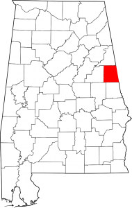
Randolph County Alabama
Randolph County population is 22,913. Its county seat is Wedowee. Its name is in honor of John Randolph, a member of the United States Senate from Virginia.
The first county seat for Randolph County was established in 1833 at Hedgeman Triplett’s Ferry on the west bank of the Big Tallapoosa River, about 10 miles (16 km) west of Wedowee. In 1835 (2 years later), the county seat was moved by the commissioners to nearby Wedowee. Wedowee lies in the center of Randolph County, on a fork of the Little Tallapoosa River. Wedowee was named after a tribal chief “Wah-wah-nee” (or “Wah-dow-wee”) whose village stood near the present site of the town.
Cities: Roanoke
Towns: Wadley, Wedowee, Woodland
Communities: Almond, Bacon Level, Corinth, Folsom, Graham, Hobson, Liberty Grove, Louina, Morrison Crossroads, Newell, Rock Mills
If you would like to become a sponsor, advertise a related location, service or vacation spot that would add to the usefulness of this site, please email us: staff@digitalalabama.com.
Links:
[links category_name=”Randolph County” fblike=”0″]

