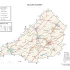
BLOUNT COUNTY ALABAMA
Blount County Alabama
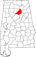
Blount County population is 57,322. Its county seat is Oneonta. Blount County was created by the Alabama Territorial Legislature on February 6, 1818, formed from land ceded to the federal government by the Creek Nation on August 9, 1814. This county lies in the northeastern quadrant of the state, which is sometimes known as the mineral region of Alabama.
Blount County Alabama History
This county was formed in 1818, and named in honor of Governor Wm. G. Blount, of Tennessee. It is noted for the abundance of its minerals, the diversity of its soils, the variety of its productions, and mineral waters. In its progress, it is keeping pace with the surrounding counties, and is ranked among the best in the State. Its area is 700 square miles.
Population in 1870, 9,945; population in 1880, 15,369. White, 14.210; colored, 1,159.
Tilled Land: 68,860 acres. Area planted in cotton, 12,502 acres; in corn, 29,161 acres; in oats, 4,551 acres; in wheat, 10,087 acres; in tobacco, 48 acres; in sweet potatoes, 371 acres.
Cotton Production ; 4,442 bales.
The face of the country in Blount is rather peculiar. It is penetrated through the center by a plateau which occupies a belt from eight to ten miles in width. On one side of this mountain plateau, running parallel with it, is Murphree’s Valley, while on the opposite side is Browns Valley. Along this belt of plateau are found excellent farming lands, which have been wonderfully assisted during the last few years by the moderate use of fertilizers. Cotton grows most readily upon this broad upland, especially if a little assisted with fertilization.
Because of the greater ease of cultivation, the farmers of the county have come, in many instances, to prefer these elevated soils to those of the valleys for cotton-producing purposes. As pasture landsthese can not be excelled in the county. There is a combination of elements here that favor the raising of stock, among which may be mentioned, an adequate supply of water, and soils favorable to the growth of clovers and grasses. Perhaps a better section than this plateau can not be found in Alabama for the production of fruits. As fine apples and peaches grow here as are produced in the South. Indeed, Blount has the reputation of being the best apple growing county on the continent. The character of the climate is such as to favor a certain crop almost annually. It is very rare, that the fruit crop is cut off by frosts. The valley lands are intrinsically more ferlile than those which lie along the broad plateau.
The soils of both the valleys are, in some instances, as rich as those which belong to the famous Tennessee Valley. Even along these valleys, there are flinty ridges which break the evenness of the lands, but between these exist the most productive soils. The most of the cotton raised in Blount is grown upon the loamy valleys. In addition to corn and cotton, the county produces oats, wheat, tobacco, sweet potatoes, rye, and sorghum.
It has for several years producd a great deal of wool, and as stockraising increases, there is no doubt that this product will correspondingly increase.
The main streams of Blount are Mulberry, Locust, and Blackburn Forks, and Big Spring creek.
The principal timbers are beech, walnut, poplar, sycamore, post and Spanish oaks, hickory, wild cherry, pine, and black gum.
The county took the premium at the Atlanta Exposition for the largest and finest specimens of wild cherry. Vast districts of the county are overspread with forests of timber.
Transportation is afforded through the medium of the great Louisville and Nashville railroad, which traverses it from the north to the south. Another railroad is in contemplation and is expected soon to be built from Birmingham to Guntersville on the Tennessee river. This road will penetrate the heart of the famous Murphree’s Valley, and along its route, from one terminal point to the other, will prevail vast deposits, both of coal and iron. The road will prove of incalculable advantage to the population residing in the region through which it will pass. Such is the attractiveness of this region that it will serve speedily to allure a population as soon as itsresources of mine and soil are known.
Excellent school and church facilities exist in almost every portion of the county. Blountsville, the seat of justice, Bangor, Summit, Hanccville, and Garden City, are places of importance. The industries of the county are varied. Extensive limeworks are seen at Blount Springs. Limestone, dug from the quarries here, is daily shipped in large quantities to Birmingham, where the manufacturers hold it in repute above any other available limestone. It prevails in inexhaustible stores, in hills about Blount Springs. Coal and iron are abundant in the county. Petroleum is also found. Enjoying, as it does, facilities for transportation to the markets of the South, North, and all points in the far Northwest, nothing prevents Blount from taking rank with the foremost counties of the State.
Blount Springs, situated immediately upon the Louisville and Nashville railroad, is the favorite watering place of Alabama. These famous Springs are 130 miles north of Montgomery, and are embosomed in the most picturesque mountain scenery. The waters are especially adapted to the cure of scrofula, rheumatism, dyspepsia, and all affections of the bladder and urinary organs.
Here, as in the adjoining counties which lie along the railroad, the value of the lands diminishes as they recede from the line of communication. Land can be purchased in the county at prices ranging from $5 to $35 per acre. There are 34,320 acres of government land in Blount county.
Source: Alabama As It Is, By Rev. B. F. Riley, D. D., 1887
Blount County Historical Destinations
Blountsville Historical Park*
Blountsville
Horton Mill Bridge
Oneonta
Old Easley Covered Bridge
Oneonta
Swann Covered Bridge
Cleveland
Blount County Memorial Museum
Oneonta
Blount County Alabama Cities:
Oneonta, Alabama
Address: 202 3rd Avenue East Oneonta, AL 35121Telephone: (205) 274-2150
Fax: (205) 274-2156
Oneonta, Alabama is the county seat of Blount County. Oneonta is home to the Covered Bridge Festival. During World War II, a small POW camp was operated outside of Oneonta. It is situated in Murphree Valley between Red Mountain and Sand Mountain to the northwest and Straight Mountain to the southeast. U.S. Route 231 passes through the center of the city, leading northwest 7 miles to Cleveland, Alabama, and southeast 14 miles to Interstate 59 in Ashville. According to the U.S. Census Bureau, the city has a total area of 15.3 square miles, of which 15.2 square miles is land and 0.077 square miles, or 0.54%, is water.
Warrior, Alabama

Warrior is the northernmost city in Jefferson County, with outlying parts of the city in Blount County. It is traversed by I-65 and U.S. Highway 31. According to the U.S. Census Bureau, the city has a total area of 9.8 square miles, all land. Warrior is in the Central time zone. The elevation at the center of town is 564 feet (172 m), though it ranges from over 620 feet (190 m) north of the center to less than 300 feet (91 m) along the Locust Fork of the Black Warrior River, which forms the southern boundary of the city.
Blount County Alabama Towns:
Allgood, Alabama
Allgood, formerly known as Chepultepec, is a town in Blount County. At the 2010 census the population was 622. The town’s name comes from a family of homesteaders from South Carolina who settled in the area in the early 19th century.
Altoona, Alabama
Altoona had its start in the year 1900 as a mining town, and was named for another coal town, Altoona, Pennsylvania. A post office has been in operation at Altoona since 1900. It incorporated in 1908.
Blountsville, Alabama
What became Blountsville appears on an 1819 map as the mixed Creek/Cherokee Native American village of “Wassausey” (meaning Bear Meat Cabin, the name of an Indian translator who lived there). The town was established by Caleb Fryley and Johnny Jones in 1816 as Bear Meat Cabin. The post office was opened as Blountsville on October 20, 1825, and incorporated on December 13, 1827. It was the county seat until 1889 when the government was moved to Oneonta. A major crossroads in early Alabama, Blountsville became a Confederate depot for the cavalry. Confederate forces led by General Nathan Bedford Forrest and Union forces led by General Abel Streight skirmished briefly in the town on May 1, 1863.
Cleveland, Alabama
Cleveland is located in central Blount County.The Locust Fork of the Black Warrior River flows past the northwest side of the town. U.S. Route 231 intersects Alabama State Route 79 north of the center of town. Route 231 leads southeast 7 miles to Oneonta, the county seat, and north 56 miles to Huntsville. Route 79 leads northeast 31 miles to Guntersville and southwest 37 miles to Birmingham.
Cleveland Alabama City Hall
62732 US Highway 231
Cleveland, Alabama 35049
(205) 274-9640
County Line, Alabama
County Line’s name is literal; half the town lies in Jefferson County, and the other half in Blount County. The town incorporated on August 27, 1957, to avoid being annexed and taxed by nearby Trafford, which lies mainly in Jefferson County but also partly in Blount County. This community sits on the Blount Mountain Range, which is one of the foothills of the Appalachian Mountains. Garden City, Alabama
Hayden, Alabama
Hayden, Alabama is centrally located between Huntsville and Birmingham with easy access to I-65. Whether you are looking for an area to build your business or raise your family, the Town of Hayden is exactly the area you have been searching for. With an industrial park located within minutes of I-65 Hayden is a great place to locate your business with a lower tax rate than our neighboring counties and municipalities. We are far enough away from the big cities to raise your family in a hometown environment yet close enough so that you can still enjoy shopping and dining without sacrificing that small town life.
Highland Lake, Alabama
The community of Highland Lake grew up around an artificial lake originally named Shuff Lake after Hugh Shuff, the engineer who created it in 1954. Shuff oversaw construction of an earthen dam across the Blackburn Fork of the Little Warrior River, resulting in a 257-acre lake that was to be used for irrigation and recreation.
Locust Fork, Alabama
While traveling south with his troops, General Andrew Jackson camped at the fork of the river in 1813. General Jackson carved his name in a Locust tree naming this area Locust Fork.
In 1817 the Hanby family came from Virginia and settled in this community on a tract of land near the Polly Martin Ford on the Warrior River. They built a three-story log house used as an inn. Gabriel Hanby died in March 1826 and is buried in the Hudson Cemetery. He is credited with being the first Blount County citizen to represent Blount County in the Alabama State Legislature.
In the early 1800s Nick Hudson built a public inn in what is now Locust Fork. He erected barns to shelter the horses and hogs of the Tennessee farmers who drove them to the deeper South for a more profitable market.
The first church in the community was built by slave labor near Robinette Springs. Tabernacle, a Methodist church, was used for both school and church activities.
Nectar, Alabama
The area now incorporating the town of Nectar was a settlement that had existed before Alabama became a state in 1819. During the Creek War of 1813-14, Andrew Jackson and his troops reportedly camped in the vicinity. This area was originally known as Tidmore for Henry Tidmore, the first postmaster in the area in 1902. It is unknown when or why the town’s name was changed to Nectar.
Rosa, Alabama
Rosa is located in central Blount County. Its town limits extend southeast to border the city of Oneonta, the county seat. U.S. Route 231 passes through the center of Rosa, leading southeast 4 miles to the center of Oneonta and 18 miles to Interstate 59 near Ashville. US-231 leads west 3 miles to Cleveland and then north 60 miles to Huntsville.
Snead, Alabama
The Snead area was settled as early as 1839, when the federal government deeded land to John Jackson. In 1853, physician G. W. White purchased land and built a water-powered flour and grist mill next to the falls on the Warrior River. In 1874, White built a store in the community.
The first post office opened in 1882, and the town was named Snead after its first postmaster, John Snead.
Susan Moore, Alabama
For most of its existence the town of Susan Moore was known by the name Clarence. The area was settled first by the Robert M. Moore family around 1865, and the family continued to play a prominent role in the town for many years. In 1923, two grandsons of Robert Moore, both doctors, donated funds for a new high school, which they named in honor of their mother, Susan Moore. The town gradually came to be referred to as Susan Moore. In November 1982, the town was incorporated, and in December an election was held to determine the new mayor and town council. One of the council’s initial actions was to officially rename the town Susan Moore.
Susan Moore, Alabama Historical Marker
Blount County Alabama Communities:
Smoke Rise, Alabama
Smoke Rise lies east of Interstate 65 in western Blount County, with most homes sitting atop Bryant Mountain or in the valley below. The community began in the late 1960s as a large planned residential subdivision. Residents founded the Smoke Rise Homeowners Association in the mid-1990s, but the community remains unincorporated despite occasional discussion of an incorporation vote.
Bangor, Alabama
Bangor, also known as Coopers Gap, Copperas Gap, or Coppers Gap, is an unincorporated community in Blount County. Nearby Bangor Cave housed a speakeasy during Prohibition and continues to be a popular attraction for area spelunkers.The community lies east of Interstate 65 and approximately 30 miles north of Birmingham.
Bangor is located near the former resort community of Blount Springs. In 1937, the landowner of Bangor Cave, J. Breck Musgrove, convinced investors to provide funds for the construction of a nightclub in the cave. The cave soon included a bar, electric lighting, a bandstand, and a lounge for women. A locked room contained slot machines, roulette wheels and card tables. A spur track of the Louisville & Nashville Railroad could drop visitors off at the entrance to the cave. The caveowners faced legal battles with Alabama governor Bibb Graves, and the Bangor Cafe Club was permanently closed in January 1939.
Bright Star, Alabama
Bright Star, also spelled Brightstar, is an unincorporated community in Blount County. A post office was established as Brightstar in 1889, and remained in operation until it was discontinued in 1907. Bright Star has been noted for its unusual place name.
Brooksville, Alabama
Brooksville is an unincorporated community in Blount County, located at the junction of U.S. Route 278, Alabama State Route 74, and Alabama State Route 79, 8.7 miles northeast of Blountsville.
In 1999 Brooksville attempted to incorporate itself. Proponents of the move stated that the laws of the community would be based on the King James Bible and the Ten Commandments.
Deavers Town Alabama
Deavers Town is a populated place located in Blount County at latitude 33.923 and longitude -86.587.
Hopewell, Alabama
Hopewell is an unincorporated community in Jefferson County. Today it lies mostly within the corporate limits of the City of Bessemer. The historic Sadler Cemetery lies nearby which contain the graves of many pioneer settlers of western Jefferson County.
Little Warrior, Alabama
Little Warrior is an unincorporated community in Blount County. A post office called Little Warrior was established in 1852, and remained in operation until it was discontinued in 1905. Little Warrior has been noted for its unusual place name.
Mount High, Alabama
Mount High, also known as High Mount, High Mound, or Highmound, is an unincorporated community in Blount County, located approximately two miles west of Interstate 65 and Smoke Rise, and approximately 25 miles north of Birmingham. Mount High also is just southwest of Rickwood Caverns State Park.
Remlap, Alabama
Remlap is an unincorporated community in Blount County, located along Alabama State Route 75, 11.7 miles southwest of Oneonta.
Remlap is named for the area’s Palmer family; the community’s name is “Palmer” spelled backwards.
Sky Ball, Alabama
Sky Ball, also spelled Skyball, is an unincorporated community in Blount County. Sky Ball has been noted for its unusual place name.
Straight Mountain, Alabama
Straight Mountain, also spelled Streight Mountain, is an unincorporated community in Blount County. Straight Mountain has been noted for its unusual place name.
Summit, Alabama
Summit is an unincorporated community in Blount County. Summit is located along County Route 48 (CR-48) near US-231/SR-53, 10.1 miles northeast of Blountsville. Summit, along with its many caves, is the setting of O. Henry’s short-story “The Ransom of Red Chief”
Blount County Alabama Ghost Towns
Bird
N34 01.787′, W86 23.350′ Type Site: Ghost Info: LOCATED ABOUT 4 MILES WEST OF ALTOONA ON CR 42.
Birdie
34°10’01.2″N 86°32’31.2″W
Blount Springs
Dates From: 1830. Once the site of a turn-of-the-century resort.
Bright Springs
N34 09.624′ W86 25.810′
Champion
Dates From: 1890
N33 56.147′ W86 26.734′
33.935783, -86.445567
Hendrix
N34 02.286′ W86 27.204′
34°02’17.2″N 86°27’12.2″W
34.038100, -86.453400
Inland
N33 50.977′, W86 33.913′
33.849617, -86.565217
Also known as Inland Junction
Lehigh
Dates From: 1905
N33 51.255′ W86 41.031′
33.854250, -86.683850
Linton
N33 50.011′ W86 48.075′
33.833517, -86.801250
McLarty
Dates From: 1883
N34 10.606′ W86 34.112′
34.176767, -86.568533
Murphee
N33 59.842′ W86 24.482
33.997367, -86.408033
Located just southeast of Countyr Road 39.
Murphrees Valley
33.984667, -86.416200
Rockland
Dates From: 1817
N33 53.557′ W86 45.469′
33.892617, -86.757817
Roswell
N34 12.935′ W86 32.198′
34.215583, -86.536633
Royal
Dates From: 1890
N34 04.323′ W86 30.132′
34.072050, -86.502200
Close to the junction of County Road 31 and County Road 26.
Taits Gap
N33 57.890′ W86 23.966′
33.964833, -86.399433
Wynnville
N34 04.864′ W86 23.614′
Blount County Alabama Weblinks
P.O. Box 94 Oneonta, AL 35121 |council@BlountEDC.com |lbaker@BlountEDC.com |
p. 205.625.3305
f. 205.625.3302
One day in 1907, George Clements stood in the doorway of the house he had built in the Straight Mountain area of Blount County, Alabama, and looked out. What he probably saw, here in the foothills of the Appalachian Mountains, was a mostly undeveloped wilderness. There were a few scattered houses and dirt trails, a small farm or two, lots of trees, and a vast upland marsh through which flowed the Blackburn Fork of the Little Warrior River.
Today you can stand in the doorway of the “Anchor," located on the site of George Clements’ house, and see a beautiful 257-acre mountain lake, circled by a paved road, and a shoreline dotted with houses, piers, and trees. You probably will see a fisherman or two on the lake, testing their luck and perhaps some water skiers enjoying a cool escape from summer in the city.
This is the history of how a wilderness mountain valley became a lake community, providing recreational facilities for hundreds of people each year.