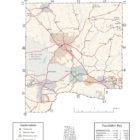
DALE COUNTY ALABAMA
Dale County Alabama

The area now known as Dale County was originally inhabited by members of the Creek Indian nation, who occupied all of southeastern Alabama during this period. The county, together with the surrounding area, was ceded to the United States in the 1814 Treaty of Fort Jackson, ending the Creek Indian Wars.
Dale County population is 50,251 and its county seat and largest city is Ozark, Alabama.
Dale County was created by the Alabama legislature on 1824, Dec. 22. It was named for Gen. Sam Dale, pioneer and Indian fighter. Dale County is located in the southeastern part of the state, wholly within the coastal plain. Approximately forty miles from Georgia and forty miles from Florida, this area is known locally as the Wiregrass, named for a particularly hardy species of grass that grew in abundance when pioneers first came here one hundred and eighty years ago.
The vast majority of Fort Rucker U.S. Army Aviation Center for Excellence is located in Dale County.
Dale County Alabama Cities:
Daleville Alabama
Daleville is a city in Dale County. At the 2010 census the population was 5,295 up from 4,653 in 2000. The city’s nickname is “Gateway to Fort Rucker”, as this U.S. Army post is located just north of town. Cairns Army Airfield is located to the south of Daleville on the road to nearby Clayhatchee.
Daleville, originally known as “Dale’s Court House”, was founded in 1827 by veterans of the Creek Indian War who had settled in Dale County following that conflict. It was established as the original county seat of Dale County in 1827 but lost that honor when Coffee County split from Dale in 1841, at which time the seat was moved first to Newton, and then later to Ozark in 1870, where it remains today.
Dothan Alabama
Dothan is a city in Dale, Henry, and Houston counties. It is the county seat of Houston County and the seventh largest city in Alabama, with a population of 65,496 at the 2010 census. It is near the state’s southeastern corner, approximately 20 miles west of the Georgia state line and 16 miles north of Florida. It is named after the biblical city where Joseph’s brothers threw him into a cistern and sold him into slavery in Egypt.
Enterprise Alabama
Enterprise is a city in the southeastern part of Coffee County and the southwestern part of Dale County in southeastern Alabama. Its population was 26,562 at the 2010 census.
Enterprise is famous for the Boll Weevil Monument, a large monument of a woman holding a boll weevil, in the middle of Main Street. The city erected the statue because the destruction of the cotton crop by the boll weevil had led to agricultural diversity, starting with peanuts and more prosperity than had ever come from cotton alone. It the only statue to an insect pest in the world. Enterprise is right outside the U.S. Army’s Fort Rucker, the home of Army Aviation.
Level Plains Alabama
Level Plains is a small city in Dale County. At the 2010 census the population was 2,085. It was incorporated on April 30, 1965.
Ozark Alabama
Ozark is a city in and the county seat of Dale County. As of the 2010 census, the population of the city was 14,907. The Ozark area was originally inhabited by the Muscogee people.
The first known European settler in Ozark was John Merrick, Sr., a veteran of the Revolutionary War, in 1822. In honor of him, the town was named Merricks. It was later changed to Woodshop, which was its name when the town received its post office. The first appearance of the name Ozark was in 1855, when the citizens requested a name change.
The county seat was moved from Newton to Ozark 1870.
Dale County Alabama Towns:
Ariton Alabama
Ariton is a town in Dale County. At the 2010 census the population was 764. It was incorporated in April 1906. The name is a blend of its two predecessor town names: Ariosto and Charlton.
Clayhatchee Alabama
Clayhatchee is a town in Dale County, Alabama. At the 2010 census the population was 589, up from 501 in 2000. It was incorporated in April 1967. Clayhatchee is located in southwestern Dale County at 31°14′16″N 85°42′46″W (31.237743, -85.712679), between Claybank Creek to the west and the Choctawhatchee River to the east. Alabama State Route 92 passes through the center of town, leading east 20 miles to Dothan (via U.S. Route 84) and northwest 10 miles to Enterprise (via AL 167). Alabama State Route 85 leads north from Clayhatchee 5 miles to Daleville and southwest 17 miles to Geneva.
Grimes Alabama
Grimes is located in the southeastern corner of Dale County in the southeastern corner of the state. Grimes was originally called Abbeville Junction. The name changed to Grimes in 1893 after a railroad depot was established, connecting it to Abbeville via the Abbeville Southern Railway. Grimes was first incorporated in May 1912, but it never actually formed a city government. Its articles of incorporation were dissolved in November 1947.
Midland City Alabama
Midland city is in Southeastern Dale County, Southeast of Dothan, and to the West of Pinckard, as well as northwest of Ozark, Alabama.
Napier Field Alabama
Napier Field is located in the southeastern corner of Dale County in the southeastern corner of the state northwest of Dothan.
An interesting history of Napier Field can be read at Encyclopedia of Alabama.
Newton Alabama
Newton is a town in Dale County, Alabama, United States. At the 2010 census its population was 1,511. Once the county seat of Dale County, Newton lost this distinction to nearby Ozark in 1870, and is now a small farming community. It incorporated in 1887. The Choctawhatchee River flows just to the north and west of Newton. At one time this waterway was navigable by steamboat from its mouth in Choctawhatchee Bay, Florida all the way to Newton.
The town was a scene for Confederate recruiting during the Civil War, and was the site of a battle in March 1865 between local Home Guard troops and elements of the 1st Florida Cavalry (US) operating out of Florida. The Federals were led by Joseph Sanders, a Dale County resident who had previously been a captain in the 31st Georgia Infantry, but had later switched sides and joined the Federals. Seeking to burn the county courthouse, the attackers were repulsed when local troops ambushed their column as they entered the town. This event is commemorated by a monument located in downtown Newton, and by annual re-enactments.
Alabama State Route 123 and Alabama State Route 134 both pass through Newton.
Pinckard Alabama
Pinckard is a town in Dale County, Alabama, United States. At the 2010 census the population was 647. Pinckard incorporated in 1893.
Dale County Alabama Communities:
Fort Rucker Army Base Alabama
Arguta Alabama
Arguta is an unincorporated community in Dale County.A post office operated under the name Arguta from 1891 to 1906.
Barefield Crossroads Alabama
Barnes Alabama
Barnes, also known as Barnes Cross Roads or Burns, is an unincorporated community in Dale County. Barnes is located on Alabama State Route 123, 4.6 miles south-southeast of Ariton.
Beamon Alabama
Bells Crossroads Alabama
Bertha Alabama
Bertha is an unincorporated community in Dale County.
Bethel Alabama
Browns Crossroad Alabama
Clopton Alabama
Clopton is an unincorporated community and census-designated place in Dale County. Clopton is located on Alabama State Route 105, 10.9 miles west-northwest of Abbeville.
Dill Alabama
Dillard Alabama
Dykes Crossroad Alabama
Echo Alabama
Ewell Alabama
Gerald Alabama
Kelly Alabama
Mabson Alabama
Mabson is an unincorporated community in Dale County.
Marley Mill Alabama
Plainview Alabama
Roberts Crossroads Alabama
Rocky Head Alabama
Rocky Head, also known as Rockyhead, is an unincorporated community in Dale County. Rocky Head is located on Alabama State Route 51, 3.6 miles southwest of Ariton. Rocky Head was founded three miles south of where the community is today. The name of the community described the site of the original post office, which sat near the head of Claybank Creek. The community kept its original name after moving to its current site. A portion of the 15th Regiment Alabama Infantry came from Rocky Head.
Skipperville Alabama
Sylvan Grove Alabama
Waterford,Alabama
Waterford is located about 85 miles south-southeast of of Montgomery.
Wicksburg Alabama
Dale County Alabama Historic Destinations
J.D. Holman House
Ozark
U.S. Army Aviation Museum
Fort Rucker
Carillon and Bell Tower
Ozark
Dale County Alabama Ghost Towns
Grimes Alabama
Latitude N31 18.281′ Longitude W85 26.879′
31°18’16.9″N 85°26’52.7″W
31.304683, -85.447983
Mabson Alabama
Latitude N31 28.097′ Longitude W85 33.779′
31°28’05.8″N 85°33’46.7″W
31.468283, -85.562983
Pinckard Alabama
Latitude N31 18.692′ Longitude W85 33.181′
31°18’41.5″N 85°33’10.9″W
31.311533, -85.553017
Dale County Alabama Links
Complementing the city's inviting business climate and tax structure is a workforce equipped with career training from Ozark's educational institutions and those within commuting distance.
Dale County was named for Gen. Sam Dale, pioneer and Indian fighter. Dale County is located in the southeastern part of the state, wholly within the coastal plain. Approximately forty miles from Georgia and forty miles from Florida, this area is known locally as the Wiregrass, named for a particularly hardy species of grass that grew in abundance when pioneers first came here one hundred and eighty years ago.Midland city is in Southeastern Dale County, Southeast of Dothan, and to the West of Pinckard, as well as northwest of Ozark, Alabama.
Dale County was named for Gen. Sam Dale, pioneer and Indian fighter. Dale County is located in the southeastern part of the state, wholly within the coastal plain. Approximately forty miles from Georgia and forty miles from Florida, this area is known locally as the Wiregrass, named for a particularly hardy species of grass that grew in abundance when pioneers first came here one hundred and eighty years ago.