FRANKLIN COUNTY ALABAMA
Franklin County Alabama
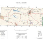
Franklin County is a county of Alabama. As of the 2010 census, the population was 31,704. Its county seat is Russellville Alabama. Its name is in honor of Benjamin Franklin, famous statesman, scientist, and printer.
In 1806, former vice president Aaron Burr hid for two weeks in Dismals Canyon, located in the town of Phil Campbell in the northeastern part of the county, to avoid arrest on treason charges after being discovered attempting to raise an army and take over the southern United States.
In 1820, the federal government completed Jackson’s Military Road (named for Gen. Andrew Jackson), which shortened travel time between Nashville and New Orleans, through portions of Franklin County.
In 1840, the county became one of the leading iron manufacturers in the state. Iron produced at the Cedar Creek Iron Works aided both the Mexican War and Civil War efforts. The furnace was destroyed in July 1864 during Union general Lovell H. Rousseau’s raid through Alabama.

Franklin County Alabama population is 31,704. Its county seat is Russellville.
Franklin County Alabama Cities:
Red Bay Alabama
Red Bay is located in western Franklin County in the northwest corner of the state, approximately one mile from the Alabama-Mississippi state line. The western border of the city is the Mississippi state line. It is situated on the Tennessee Valley divide, with the northern half of the city draining north to Bear Creek, a tributary of the Tennessee River, and the southern half draining south to Gum Creek, a tributary of the Tombigbee River.
Russellville Alabama
Russellville is a city in Franklin County. At the 2010 census, the population of the city was 9,830, up from 8,971 at the 2000 census. The city is the county seat of Franklin County.
After the War of 1812, the U.S. government appropriated money to improve a route from Nashville to New Orleans. It was named Jackson’s Military Road after Andrew Jackson, and it passed through what became Russellville. (Present-day Jackson Avenue and Jackson Highway, U.S. Route 43, follow portions of the original road.)
Franklin County Alabama Towns:
Hodges Alabama
A community known as “Reid Brake” was established at what is now Hodges in the 1880s. The current town was was laid out in 1902 and established in 1907 as a stop along the Illinois Central Railroad. The town incorporated in 1913, and reincorporated in 1919.
Hodges is a town in Franklin County. At the 2010 census the population was 288.
Phil Campbell Alabama
In the 1880s, a railroad work crew leader and engineer by the name of Phillip Campbell (originally from England) established a work camp near the location of modern Phil Campbell. Mel Allen, a prominent local businessman, told Mr. Campbell if he would construct a railroad depot and add a side track to the stretch of railroad going through the area, he would name the subsequent town after Campbell. Mr. Campbell built both the depot and siding, which led to Phil Campbell being the only town in Alabama to have both the first and last names of an individual.
Vina Alabama
Vina is a town in Franklin County. Vina was originally known as “Jones Crossroads,” and later as “New Burleson.” When a branch of the Illinois Central Railroad was constructed through the area in the early 1900s, the community was renamed “Vina” after the wife of a railroad engineer.
Franklin County Alabama Communities:
Atwood Alabama
Atwood is an unincorporated community located in southern Franklin County. It is located along Alabama Highway 172 between the towns of Hodges and Vina. Atwood is situated just south of the Bear Creek Reservoir.
Belgreen Alabama
Belgreen is a census-designated place and unincorporated community in Franklin County, located nine miles west of Russellville and around 17 miles east of Red Bay on Alabama Highway 24. As of the 2010 census, its population was 129.
Burntout Alabama
Burntout is an unincorporated community in Franklin County. Local legend states that during the Civil War a group of Union soldiers stopped to camp at a church just outside Red Bay. During the night, a soldier knocked over a lantern and started a fire. Local settlers came together to replace the burned church and decided to call it Burnout Church, a name also adopted by the surrounding community.
Halltown Alabama
Halltown, also known as Alanthus, is an unincorporated community in Franklin County. Halltown is located along Alabama State Route 24, 4.9 miles east-northeast of Red Bay.
Liberty Hill Alabama
Liberty Hill is an unincorporated community in Franklin County. Liberty Hill is located on U.S. Route 43 and Alabama State Route 17, 3.4 miles west of Phil Campbell.
Nix Alabama
Nix is an unincorporated community in Franklin County.
Old Burleson Alabama
Old Burleson is an unincorporated community in Franklin County. A post office operated under the name Burleson from 1848 to 1909.
Pleasant Site Alabama
Pleasant Site is an unincorporated community in Franklin County. During the Civil War, Company B of the 27th Alabama Infantry (known as the “Confederate Sentinels”) was organized at Pleasant Site.
Pogo Alabama
Pogo is an unincorporated community in Franklin County.
Seven Pines Alabama
Seven Pines is an unincorporated community in Franklin County. Seven Pines is located on Alabama State Route 247, 4.1 miles northeast of Red Bay.
Spruce Pine Alabama
Spruce Pine is a census-designated place and unincorporated community in Franklin County. Its population was 222 as of the 2010 census.
Franklin County Alabama Ghost Towns
Baggett Alabama
Latitude N34 22.807′ Longitude W87 59.547′
34°22’48.4″N 87°59’32.8″W
34.380117, -87.992450
Dime Alabama
Latitude N34 19.146′ Longitude W87 38.073′
34°19’08.8″N 87°38’04.4″W
34.319100, -87.634550
Good Springs Alabama
Latitude N34 32.506′ Longitude W87 41.822′
34°32’30.4″N 87°41’49.3″W
34.541767, -87.697033
Hargett Mills Alabama
Latitude N34 31.217′ Longitude W87 38.937′
34°31’13.0″N 87°38’56.2″W
34.520283, -87.648950
Mount Alabama
Latitude N34 34.220′ Longitude W87 46.013′
34°34’13.2″N 87°46’00.8″W
34.570333, -87.766883
Pleasant Site Alabama
Latitude N34 32.5201 Longitude W88 03.913′
34°32’31.2″N 88°03’54.8″W
34.542002, -88.065217
Rockwood Alabama
Latitude N34 27.306′ Longitude W87 47.081′
34°27’18.4″N 87°47’04.9″W
34.455100, -87.784683
Waco Alabama
Latitude N34 28.917′ Longitude W87 39.229′
34°28’55.0″N 87°39’13.7″W
34.481950, -87.653817
Franklin County Alabama Destinations
Alabama’s newest horse trails, the Rock Bridge Canyon Equestrian Park
The National Natural Landmark Dismals Canyon
Cypress Cove Farms, a historic Appalachian Village
Fishing, camping, swimming and white water rafting at Bear Creek Lakes
Tammy Wynette displays at the Red Bay Museum
Franklin County Alabama Places of Interest:
Cedar Creek, a tributary of the Tennessee River, flows through the north-central area of the county, and Bear Creek, also a tributary of the Tennessee River, flows through the southwestern corner of the county. Bear Creek is a popular area for Canoeing and kayaking.
In the late 1960s, the Tennessee Valley Authority (TVA) built a reservoir on Bear Creek, creating Bear Creek Lake. In 1978, the TVA dammed Cedar Creek, creating Cedar Creek Lake. Mud Creek, a tributary of the Luxapilla Creek, runs through the eastern half of the county.
Dismals Canyon has been voted one of the country’s most secluded and beautiful areas. The canyon includes waterfalls, more than 350 species of flora, and what are known colloquially as “dismalites,” strange glowing insects called fungus gnats.
A portion of the William Bankhead National Forest is located on the southeastern border of the county. Bridge Canyon is home to Alabama’s largest rock formation, a giant sandstone cliff embedded with quartz deposits that rises 285 feet. Located near Hodges in the northern area of the county, the canyon also contains caves, springs, waterfalls, and an 82-foot-long natural bridge.
Franklin County Alabama Churches
Adams Memorial Church Hackleburg
Alva Chapel Russellville
Antioch Church Old Bethel
Asbury United Methodist Church Russellville
Atwood Church Hodges
Ball Park Church Hackleburg
Bear Creek Church Hackleburg
Bethel Church Phil Campbell
Bethlehem Church Russellville
Bethlehem Church Kinlock Spring
Bethsaida Church Old Bethel
Beulah Church Newburg
Block Church Spruce Pine
Blue Springs Church Spruce Pine
Bradley Chapel Church of Christ Guinn Cross Roads
Burleson Church Halltown
Burleson Church Halltown
Burntout Church Halltown
Calvary Baptist Church Russellville
Cedar Creek Church Isbell
Cedar Creek Church Pleasant Grove
Cedar Creek Cumberland Presbyterian Church Frankfort
Cedar Grove Church Spruce Pine
Center Brook Church Red Bay
Centerview Church Frankfort
Cherry Hill Church Newburg
Church of Christ Halltown
Coker Church Halltown
College Avenue First Baptist Church Russellville
Community Center Baptist Church Red Bay
Community Center Church Halltown
Concord Baptist Church Russellville
Dime Methodist Church Phil Campbell
Dunkin Creek Baptist Church Frankfort
Dunkin Creek Church Frankfort
East Side Church of Christ Russellville
East Side Missionary Baptist Church Russellville
Ebeneezer Church Russellville
Ebenezer Church Shottsville
Edgar Chapel Hackleburg
First Baptist Church Phil Campbell
First Baptist Church Red Bay
First Baptist Church Russellville
First Methodist Church Red Bay
First Presbyterian Church Russellville
First United Church Halltown
First United Methodist Church Russellville
Five Points Church Guinn Cross Roads
Freedom Hills Church Pleasant Site
Friendship Baptist Church Russellville
Gaines Street Baptist Church Russellville
Good Spring Church Vina
Gravel Hill Church Hackleburg
Gravel Hill Church Hackleburg
Gray Rock Church Newburg
Harmony Church Pleasant Site
Hickory Flat Church Isbell
Holly Spring Church Hodges
Hurricane Creek Church Shottsville
James Chapel Church Guinn Cross Roads
Jonesboro Baptist Church Frankfort
Kimbrough Chapel Newburg
Lawler Chapel Church Hackleburg
Liberty Church Pleasant Grove
Liberty Hill Church Hackleburg
Liberty Hill Church Halltown
Light House Church Newburg
Macedonia Church Newburg
Macedonia Church Guinn Cross Roads
Mount Hebron Church Isbell
Mount Joy Church Phil Campbell
Mount Nebo Baptist Church Russellville
Mount Olive Church Spruce Pine
Mount Pleasant Church Pleasant Grove
Mount Pleasant United Methodist Church Newburg
Name USGS Topo Map
Mount Zion Church Frankfort
Mountain Home Church Newburg
Mountain Home Church Guinn Cross Roads
Mountain View Church Phil Campbell
New Bethlehem Church Kinlock Spring
New Friendship Church Isbell
New Harmony Church Phil Campbell
New Hope Church Newburg
New Pleasant Church Isbell
New Union Church Halltown
North Russellville Baptist Church Russellville
Northern Methodist Church Phil Campbell
Northside Baptist Church Red Bay
Oak Grove Church Newburg
Old Bethlehem Church Kinlock Spring
Old Line Church Hodges
Orange Baptist Church Kinlock Spring
Palestine Church Red Bay
Phil Campbell Church Phil Campbell
Phil Campbell Church of Christ Phil Campbell
Phil Campbell Church of God Phil Campbell
Phil Campbell Church of God – Seventh Day Phil Campbell
Phil Campbell Church of God of Prophecy Phil Campbell
Phil Campbell United Methodist Church Phil Campbell
Pilot Hill Church Vina
Pine Chapel Newburg
Pleasant Hill Church Newburg
Pleasant Hill Church Isbell
Pleasant Ridge Baptist Church Russellville
Pleasant Ridge Church Number One Halltown
Pleasant Site Church Kinlock Spring
Pleasant Site Church Pleasant Site
Punkin Center Church Pleasant Grove
Quinn Memorial Church Isbell
Red Bay Freewill Baptist Church Red Bay
Rockwood Church Isbell
Russellville Church of God Russellville
Russellville Freewill Baptist Church Russellville
Saint Paul Church Kinlock Spring
Shady Grove Church Phil Campbell
Shady Grove Church Hackleburg
Shady Grove Church of Christ Frankfort
Shiloh Church Halltown
Siloam Baptist Church Russellville
Sims Memorial Church Red Bay
Single Spring Church Vina
Southside Church Spruce Pine
Sparks Church Guinn Cross Roads
Spruce Pine Baptist Church Spruce Pine
Spruce Pine Church of Christ Spruce Pine
Spruce Pine United Methodist Church Spruce Pine
Sylvester Church Newburg
Temple Baptist Church Phil Campbell
Tharptown Baptist Church Russellville
Tharptown Church of Christ Russellville
Union Church Newburg
Union Hill Church Phil Campbell
Vina First Baptist Church Halltown
Vina United Methodist Church Halltown
Waco Baptist Church Spruce Pine
Waco Church of Christ Spruce Pine
Washington Avenue Church of Christ Russellville
West Highlands Baptist Church Russellville
Williams Sanctuary Church Vina
Franklin County Alabama Events:
Every August, the town of Russellville hosts the annual Watermelon Festival, which features a pageant, a 5K race, arts and crafts, and tennis tournaments.