MONROE COUNTY ALABAMA
Monroe County Alabama

Monroe County Alabama, located in the southwest part of the state, has a population of 23, 068. The county seat is Monroeville Alabama. For thousands of years the area was inhabited by indigenous peoples. In historic times, it was primarily the territory of the Creek peoples, who became known to European-American settlers as one of the Five Civilized Tribes of the Southeast.
Monroe County Alabama Cities:
Monroeville, Alabama
Monroeville is the county seat of Monroe County. The town was initially known as Walker’s Mill and Store, named for Major Walker, the area’s first white settler. In 1832, the county seat was relocated to Monroeville from Claiborne on the Alabama River. The settlement was briefly renamed “Centerville” due to its location in the center of the county, but then it was formally changed to Monroeville. The town was not formally incorporated until April 15, 1899.
Monroe County Alabama Towns:
Beatrice Alabama
Beatrice is a town in in north-central Monroe County. Beatrice was established by the Louisville and Nashville Railroad during construction of a line between Pine Apple, Wilcox County, and Repton, Conecuh County, in 1899-1900. The town prospered as a shipping center, with one of the main products being cotton from the surrounding farms.
It incorporated in 1901. At the 2010 census the population was 301, down from 412 in 2000. Of that number, 76.1 percent of respondents identified themselves as African American, 23.6 percent as white, and 0.3 percent as Native American. The town’s median household income, according to 2010 estimates, was $24,609, and the per capita income was $26,799.
The Robbins Hotel (1840) and the New Hope Baptist Church (1870) are listed on the National Register of Historic Places. Rikard’s Mill Historical Park, part of the Monroe County Heritage Museum, is located in Beatrice.
State Highway 265 runs north from the center of Beatrice, and State Highway 21 / State Highway 47 runs south and east.
Excel Alabama
Excel is a town in southeastern Monroe County, Alabama. At the 2016 Census was 985. Of that number, 92.8 percent of respondents identified themselves as white, 6.0 percent as African American, 2.4 percent as two or more races, 1.0 percent as Native American, and 0.2 percent as Asian.
The first settlers arrived in Excel around 1875. Around the turn of the century, Excel was connected by rail, allowing for economic expansion through the shipping of lumber and farm products. The rail line ceased operation in 1935, and Excel’s growth slowed by 1937.
State Highway 136 runs north and east from the center of town, and Interstate Highway 65 is located about 20 miles southeast of Excel. Monroe County Airport is located four miles to the north of the town.
Frisco City Alabama
Frisco City is a town in Monroe County, Alabama, United States.
What would become Frisco City started out as two mid-19th century communities named Lufkin and Snider. It initially incorporated as the town of Jones Mill in 1909. It was named for the owner of the local grist mill. Four years later on November 4, 1913, the town was renamed as Roy for Roy Megargel, owner of the Gulf, Florida, and Alabama Railroad (GFA). The renaming was done on the condition that “Roy” would receive a rail line to the Town.
When Megargel failed to deliver on his promise, the town reverted to its name of Jones Mill in 1919.
In 1925, the St. Louis and San Francisco Railroad bought the GFA Railroad and agreed to complete what Megargel was not able to. In 1928, the line was completed, and in gratitude, the town formally renamed itself as Frisco City (taken from San Francisco).
The old J. W. Jones home is located in the Frisco City Town Park along with the old Jones Mill Post Office, the first Jones Mill one-room jail and an old Frisco Railway caboose. Prior to being named Frisco City, the town was known as Jones Mill in honor of J. W. Jones The property for the Town Park was donated by J. W. Jones in the year 1913.
At the 2010 census the population was 1,309.
Vredenburg Alabama
Vredenburgh is a town in Monroe County, Alabama. It incorporated in 1912. At the 2010 census the population was 312. For more information Vredenburgh, read the Heritage Museum Magazine.
Monroe County Alabama Communities:
Megargel Alabama
Megargel is a census-designated place and unincorporated community in Monroe County, Alabama, United States. Its population was 62 as of the 2010 census. Named for Roy Megargel, who was the owner of the Gulf, Florida, and Alabama Railroad (GFA) in the early part of the 20th century.
Peterman Alabama
Peterman is a census-designated place and unincorporated community in Monroe County about six miles northeast of Monroeville. It is located on the Old Peterman Highway less than a hundred yards north of the Peterman Post Office (GPS coordinates 31.585351,-87.259347). Its population was 89 as of the 2010 census.
Uriah Alabama
Uriah is a census-designated place and unincorporated community in Monroe County. Uriah is located at the junction of State Route 21 and State Route 59. As of the 2010 census, its population was 294. When Uriah was full of virgin timber it was originally named Maros. Uriah is home to an annual festival called The Cotton Patch Festival. Various talents and arts and crafts are showcased during the festival.
Buena Vista Alabama
Buena Vista is an unincorporated community in Monroe County. The village of Buena Vista is listed on the Alabama Register of Landmarks and Heritage.
Burnt Corn Alabama
Burnt Corn is a small unincorporated community on the boundary between Monroe County and Conecuh County. It lies at a historic crossroads near the source of Burnt Corn Creek and the intersection of two trading paths. In 1798 the area was included in the Mississippi Territory but was controlled by the Creek Nation. Between 1805 and 1811 the area became a stop on the Federal Road through the Creek Nation. Burnt Corn was a regular stopping point for stage coaches traveling between the east and the port cities along the Gulf Coast.
Finchburg Alabama
Finchburg (also Finchberg, Finchburgh) is an unincorporated community in Monroe County.
Franklin Alabama
Goodway Alabama
Goodway is an unincorporated community in Monroe County. Goodway is located along the Alabama and Gulf Coast Railway, 6.8 miles south of Frisco City.
Manistee Alabama
Manistee is an unincorporated community in Monroe County. Manistee was a logging town, and was home to the Manistee Mill Company, Bear Creek Mill Company and Runyan-Burgoyne Lumber Company.
Mexia Alabama
Mexia is an unincorporated community in Monroe County. Mexia is located on Alabama State Route 47, 4 miles (6.4 km) west-southwest of Monroeville.
Natchez Alabama
Natchez is an unincorporated community in Monroe County. It was the birthplace of William C. Maxwell, a pilot in the United States Army Air Service and namesake of Maxwell Air Force Base in Montgomery, Alabama. The New Hope Baptist Church, located in Natchez, is listed on the National Register of Historic Places.
Old Salem Alabama
Old Salem is an unincorporated community in Monroe County.Old Salem is situated northwest of Mexia.
Old Texas Alabama
Old Texas is an unincorporated community in Monroe County. Old Texas is located on Alabama State Route 47, 12.3 miles (19.8 km) east-northeast of Beatrice.
Perdue Hill Alabama
Perdue Hill is an unincorporated community in Monroe County. It has one site listed on the Alabama Register of Landmarks and Heritage, the Perdue Hill Masonic Lodge. The home of William B. Travis is located along U.S. Route 84 in Perdue Hill and was moved here in 1985 from Claiborne.
River Ridge Alabama
River Ridge is an unincorporated community in Monroe County.
Scratch Ankle Alabama
Scratch Ankle is an unincorporated community in Monroe County, located 12 miles (19 km) northwest of Monroeville.cScratch Ankle got its name from the fact locals, who were often seen by railroad workers scratching their ankles due to excessive mosquito bites.
Tunnel Springs Alabama
Tunnel Springs is an unincorporated community in Monroe County. It has one site listed on the Alabama Register of Landmarks and Heritage, the Old Scotland Presbyterian Church.
Wainwright Alabama
Wainwright is an unincorporated community located in Monroe County, approximately 100 miles northeast of Mobile and 100 miles southwest of Montgomery.
Monroe County Alabama Ghost Towns:
Claiborne Alabama
Situated near the Federal Road, Claiborne began during the Mississippi Territory period with a ferry over the river. During the Creek War a large stockade fort, named Fort Claiborne, was established at the site by General Ferdinand Claiborne. He used the fort as a base for the invasion of the Creek nation with the Regular Army of the United States, the Lower Tombigbee Militia, and friendly Choctaw. The community of Claiborne began in 1816, on the former fort site.
Source: Wikipedia contributors, “Claiborne, Alabama,” Wikipedia, The Free Encyclopedia
Bells Landing Alabama
Latitude N31 47.813′ Longitude W97 25.298′ 31.80337, -87.41109
Located five miles north of Franklin Alabama.
For addional information on the area, see: Bell’s Landing Presbyterian Church at Bell’s Landing, AL (established 1819, present church built ca. 1927)
Finchburg Alabama
Dates from 1891. About two miles west-southwest of Wainwright Alabama
Location: 31.6426200658589, -87.51335713005668
Hixon Alabama
About four miles east-northeast of Claiborne Alabama.
31.57301666666667, -87.42605
Homewood Alabama
Latitude N31 22.179′ Longitude W87 35.962′ 31.36666666666667, -87.59933333333333
About six miles northeast of Chrysler Alabama. West of intersection of County Road 1 and railroad tracks.
Manistee Alabama
Manistee is an unincorporated community in Monroe County.Manistee was a logging town, and was home to the Manistee Mill Company, Bear Creek Mill Company and Runyan-Burgoyne Lumber Company.
Latitude N31 26.28′ Longitude W87 29.40′ / 31.441111, -87.494444
About five miles south-southwest of Perdue Hill Alabama.
Monroeton Alabama
Latitude N31 32.301′ Longitude W87 16.684′
About three miles east-northeast of Monroeville Alabama.
Nadawah Alabama
Nadawah is a ghost town in Monroe County, Alabama. Nadawah appeared on the U.S. Censuses of 1920 and 1930 as an incorporated community. It disincorporated at some point in the 1930s.
Nadawah is located at 31.8143197°N 87.1722083°W
Nadawah was named for the Nadawah Lumber Company. The Nadawah Lumber Company operated 15 miles of standard-gauge railway from 1912 to 1928. Nadawah was formerly a sawmill town in the early 20th century, located about a mile south of Wilcox County Alabama and seven miles from Beatrice Alabama. The town was near the head of Flat Creek, along the Louisville & Nashville Railroad (L&N). Besides the sawmill, it had a post office, school, hotel and stores. A post office operated under the name Nadawah from 1900 to 1967.
Monroe County Alabama Historic Destinations
Veterans Memorial Park – Monroeville Alabama
William Travis House – Perdue Hill Alabama
Monroe County Museum – Monroeville Alabana
Rickard’s Mill Historical Park – Beatrice Alabama
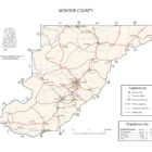
Monroe County Alabama Map