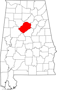
Jefferson County is the most populous county in the State of Alabama. As of the 2010 census, the population was 658,466. The county seat is Birmingham, the most populous city in the state.
Jefferson County was established on December 13, 1819, by the Alabama Legislature. It was named in honor of Thomas Jefferson. The county is located in the north-central portion of the state, on the southmost edge of the Appalachian Mountains, in the center of the (former) iron, coal, and limestone mining belt of the Southern United States.
Cities: Adamsville, Bessemer, Birmingham, Brighton, Center Point, Clay, Fairfiled, Fultondale, Gardendale, Graysville, Helena, Homewood, Hoover, Hueytown, Irondale, Kimberly, Leeds, Lipscomb, Midfield, Mountain Brook, Pinson, Pleasant Grove, Sumiton, Tarrant, Trussville Vestavia Hills, Warrior
Towns: Argo, Brookside, Cardiff, County LIne, Maytown, Morris, Mulga, North Johns, Sylvan Springs, Traffors, West Jefferson
Communities: Coalburg, Corner, Dolomite, Hopewell, McCalla, Shannon, Watson, Concord, Edgewaer, Forestdale, Grayson Valley, McDonal Chapel, Minor, Mount Olive, Rock Creek

