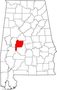
Perry County Alabama
Perry County was established in 1819 and is named in hoor of Commodore Oliver Hazard Perry of The United States Navy. The County seat is Marion Alabama.
Cities: Marion, Uniontown
Communities: Adler, Augustin, Cleveland Mills, Coleman, Cunningham, Ellards, Folsom, Hamburg, Heiberger, Hillcrest, Jericho, Levert, Morgan Springs, Nave, Norman, Oakmulgee, Osborn, Panhandle, Perryville, Radford, Sprott, Suttle, Tayloe, Vaiden, Vilula, Zimmerman
Zip Codes: 36793, 36701, 36759
If you would like to become a sponsor, advertise a related location, service or vacation spot that would add to the usefulness of this site, please email us: staff@digitalalabama.com.
Links:
[links category_name=”Perry County” fblike=”0″]
loading map - please wait...
 | First Congretational Church of Marion The First Congregational Church of Marion is a historic church at 601 Clay Street in Marion, Alabama. It was built in 1871 after the congregation was established in 1869 by freed slaves and the American Missionary Association. The congregation later became affiliated with the United Church of Christ in the 1950s. The building was added to the National Register of Historic Places in 1982. 601 Clay Street, Marion, AL, United States |
| Marion Alabama Marion is the county seat of Perry County Alabama. With a population of 3,686, Marion is the 148th most populated city in the state of Alabama. Marion, Alabama, United States |

