Early Roads and Routes in Alabama circa 1800-1839
Early Roads and Routes in Alabama circa 1800-1839
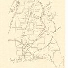
This image is a map of the state of Alabama by John Melish showing early roads and routes inside Alabama and their extension to the neighboring states. Some of the early roads and routes shown are:
- Natchez Trace,
- Gaines Road, –The Gaines Trace was a road in the Mississippi Territory. It was constructed in 1811 and 1812 from the Tennessee River (opposite the Elk River’s mouth) to Cotton Gin Port on the upper Tombigbee River and on to Fort Stoddert on the lower Tombigbee. The portion from the Tennessee River to Cotton Gin Port was surveyed in 1807 and 1808 by Edmund P. Gaines, the road’s namesake and a career United States Army officer.In 1816, the Gaines Trace and the Tombigbee River were the boundaries between United States and Chickasaw territory.Jackson’s Military Road, constructed from 1816-1820, intersected Gaines Trace in Russellville, Alabama. Tennessee Street in Courtland, Alabama, was a portion of the Trace.
- Jackson’s Military Road,
- Huntsville Road,
- Post Road From Natchez,
- Old Federal Road,
- Pensacola Road, and
- Jackson’s Route to the Creek Wars.
The map also shows counties, cities, forts, and rivers. “MP 0459” is printed at the lower right corner of the map. The map is a printed copy of an original handwritten map and is not encapsulated.
Early Roads and Routes in Alabama circa 1800-1839
This image is the property of the Auburn University Libraries and is intended for non-commercial use. Users of the image are asked to acknowledge the Auburn University Libraries. For information about obtaining high-resolution copies of this and other images in this collection, please contact the Auburn University Libraries Special Collections & Archives Department at archives@auburn.edu or (334) 844-1732.
