Choccolocco Alabama
Choccolocco Alabama
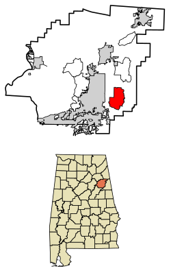
Choccolocco is an unincorporated community and census-designated place in Calhoun County, Alabama. As of the 2010 census, its population was 2,804. It was founded in 1832.
Choccolocco Meaning
Choccolocco is an Indian word, chahko- meaning “shoals”, and lago meaning“big” or a shallow creek with big shoals.
Choccolocco Monster
Choccolocco is home to the Choccolocco Monster.
Wikipedia:
The community gained brief notoriety in 2001 when The Daily Show aired a piece on the “Choccolocco Monster,” a part of local folklore concerning sightings of a mysterious creature in the area in the late 1960s. An October 2001 article in the Anniston Starnewspaper revealed that the creature was, in fact, local resident Neal Williamson dressed in a cow skull and a sheet. As a teenager, Williamson would don his costume and gain the attention of passing cars by jumping out of the woods onto the roadside, often startling motorists.
Choccolocco Creek
Choccolocco Creek is a large, beautiful creek that is an excellent sport fishery and the state record redeye bass comes from this stream. It is also a scenic float. A free put-in is available to the public further downstream at the Hwy 77 bridge.
Choccolocco Alabama Zip Code
36245
Choccolocco WMA

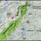
Choccolocco Mountains
Choccolocco is the Anglicization of the Creek words, choko rakko, which mean “house big.” By the 1700s, the term referred to the Creek ceremonial square, which was bounded by wooden bleachers with awnings. It was at that time, too large to have a roof, but was still called a building.
ARCHAEOLOGISTS IDENTIFY HUNDREDS OF STONE STRUCTURES IN ALABAMA’S CHOCCOLOCCO MOUNTAINS
People of One Fire:
On June 2, 2017 several TV stations, newspapers and Alternative Perceptions Magazine announced the discovery of many more Native American stone structures in the mountainous region of Alabama, east of the Coosa River and north of Interstate 85. The concentration of stone structures extends eastward into Georgia across Metro Atlanta to the Savannah River. Archaeologist, Dr. Greg Little, believes there may be thousands of more stone structures to be discovered in the Choccolocco and Talladega Mountains of Alabama.
Choccolocco Falls
The waterfall area on Bain’s Gap Road includes a picnic pavilion and foot-bridge as well as a short walking trail. The area is also a historical site with the chimney remains of an old lodge.
The many forest roads provide excellent opportunities for both biking and hiking trails, bird and wildlife watching, or just taking a short trip to enjoy the scenic mountains, secret coves and sparkling creeks and streams. There is an unimproved camping area for hunters on Joseph Springs Parkway, just west of the hunter’s check-in station.
Bain’s Gap Waterfall Area
The Anniston Star Article on Bain’s Gap Waterfall Area
Choccolocco State Forest
Nestled in the foothills of the Appalachian Mountains in Northeast Alabama is one of our state’s best kept treasures; Choccolocco State Forest.
Named for the Choccolocco Creek which runs through the valley, Choccolocco is rich in history, including Native Americans who settled the area 2500 years ago. Near the northern boundary of the mighty Creek nation, the tribe named the creek “Choccolocco.” In the Creek language “Chahko” means “shoals” and “lago” means “big. Choccolocco Creek is a wide shallow stream with big shoals, which runs north to south, roughly dividing the forest in half. Choccolocco Creek is one of the larger tributaries of the Coosa River.
Located in south eastern Calhoun County, Choccolocco State Forest comprises approximately 4,406 acres of land with around 4,392 acres being in some type of forest cover. The remaining 14 acres consists of various openings. Four major paved roads cross Choccolocco. Alabama Highway 9 runs north-south through the eastern portion of the property and Choccolocco Road runs north-south on the west side of the forest. Joseph Springs Parkway and Bain’s Gap Road run east-west through the middle.
More About
Choccolocco State Forest
Choccolocco Weather
Choccolocco Map
Old Downing Mill
Eight miles east of Sh 21 at Oxford, Alabama, turn left off US 78 onto Riddle Farm Road, go to “T”, turn left on Old Downing Mill Road. The mill is 1/4 mile on right.