Gold in Cleburne County Alabama
Gold in Cleburne County Alabama
ALABAMA GOLD – A Rich Mine Found in Cleburne County
A recent issue of the daily Hot Blast of Anniston, Ala. contains the particulars of one of the most wonderful gold discoveries ever made in the United States. The mines are located in Cleburne county thirty miles from this city. The specimens brought here today are amazing rich and would yield $300 per ton. Solid nuggets have been found weighing from 10 to 100 pennyweights. A company was formed at once to develop the property with Mr. William Noble, the celebrated iron manufacturer, as president. [Source: Vernon Courier, Lamar County AL, February 5, 1891]
The proprietor of the Crown Point Gold Mines in Cleburne county are greatly elated over the progress they have made, and will double their present capacity in a few weeks. [Source: Hamilton Times, Marion County AL, May 4, 1893
There is great activity in the gold fields in Cleburne county. A number of mines are being worked now and new miens are being opened. Real estate in the mountains of Cleburne will soon be more valuable than that of any other section of the state. [Source: Vernon Courier, Lamar County AL, May 18, 1893]
While digging a well at Heflin, J. E. Crawley, a colored man, struck a rich vein of gold ore. It is said to be very valuable and has caused great excitement around the town. [Source: Hamilton Times, Marion County AL, June 15, 1893]
Col. S. D. Howe of Pennsylvania and Mr. E. C. Canning of New Orleans, both practical and experienced mica miners, have been looking over the ground in Cleburne county and both were well pleased with what they saw. [Source: Vernon Courier, Lamar County AL, July 20 1893]
At the Southland and Wilburn gold mine, fifteen miles from Heflin, they are working with an old fashioned wooden stamp mill with a four stamp capacity and ordinary battery pans, and are saving from $15 to $20 a day. [Source: Hamilton Times, Marion County AL, September 28, 1893]
OPENING GOLD MINES – Hacks, buggies, and wagons are outgoing from Heflin each day to the newly discovered vein in the Arbacoochee gold mine. The gold is on the property of the Mark Pinson estate. Mr. Pinson owned considerable lands, some of which he considered very valuable in minerals. The Arbacoochee gold mine was worked successfully more than fifty years ago. Some fifty years ago a man by the name of Mirobee worked in this mine and only mined the find about one and a half feet. While the miners were at work Saturday they came to an old wheel. No one knew how it came to be imbedded in the creek bank. Afterwards an old man came up and said that the wheel was brought from Villa Rica when he was a little boy, more than a half century ago. It came from some old gold mine in that section, and was used by Mr. Frobee forcing the water out of his mine. Just under this old wheel was the richest deposit of gold that has ever been known in this section. Queer to say but the wooden hub of the wheel was in a perfect state of preservation. [Source: Hamilton News Press, Marion County AL, July 25, 1895]
GLISTENING WITH GOLD
– The Richness of the New Find Has Not been exaggerated – Owned by an Anniston Company
Anniston, July 19 – Mr. E. E. G. Roberts who has just returned from Arbaccochee, Cleburne county near where the rich gold vein was found Saturday was interviewed this morning by the Age-Herald correspondent. He said that the reports of the size and richness of the vein had not been exaggerated and that it fairly glistened with the yellow metal. The vein, which was found at a depth of about 30 feet, has been tested very little as yet, and there is no way of computing its value. Several thousand dollars worth of gold has already been taken out of the vein with crude and imperfect methods which are used. The property is owned by the Anniston Gold Mining Company of which William Noble and E. E. G. Roberts, both of this city, are president and secretary and treasurer, respectively. The gentlemen who were erroneously reported in the Age Herald this morning as owners have some land near by however. The Anniston Gold Mining company knew of the existence of the vein and had had the Messrs Hilton, who are practical gold miners and who discovered the vein, looking for it for four or five months. This vein is supposed to be the mother of all the placer deposits in that immediate section from which something over $1,000,000 of gold was taken in the 40s. Several California gold miners who are at Arbaccochee declare that they have never been seen or heard of anything in California or elsewhere to equal it. Scores of prospectors and capitalists have been attracted and may options asked for with but few sold. The gold fever in Cleburne has never been higher or more hopeful and the excitement is intense. Anniston is greatly interested both on account of the nearness of the fields to this city and that the rich vein is owned by an Anniston company.
GOLD LANDS SOLD
Ex-Governor Smith, of Birmingham, W. A. Searboro, of Anniston, and others the other day sold Cincinnati parties eleven thousand acres of gold lands in the Arbachoochee fields in Cleburne county for $117,000. Machinery will be put in operation and the property developed immediately.[Source: Marion County News, Marion County AL, May 13, 1897]
RICH FIND
A rich find of gold has been made by Messrs A. B. Hilton and G. Riley near Chulafince, Cleburne County [Source: Marion County News, Marion County AL, November 11, 1897
Gold in Cleburn County Alabama
There are lode mines of copper and gold and waters in the Chulafinnee Mining District give up placer gold.
Nearly 30,000 ounces of gold were produced in Cleburne county, mostly in the Arbacoochee district in the southern part of the county. Most of the gold came from placer deposits near Gold Hill and Clear Creek. All area streams and their tributaries in the Arbacoochee Mining District, which includes the northern part of Randolph County, is reportedly the richest placer ground in Alabama. All area streams and tributaries in the Chulafinnee Mining District, west of the Arbacoochee District, had significant early placer mining operations.
Along Chulafinnee Creek and its tributaries, the Chulafinnee placers, was gold rich gravels under 6 foot of overburden. The Carr Creek Placer is 240 acres of clay and gravel that contains placer gold. Area watercourse gravels and sands contain placer gold. The Arbacoochee Placer was the most extraordinary gold placer deposit in Alabama, covering 600 acres on top and sides of Gold Hill, once giving employment to 600 men. The Clear Creek placers were long famed for its rich production. The Pritchet Property had panning gold.
Arbacoochee Alabama
Gold is being sent from the Arbacooche gold mines in Cleburne count to the mint in New Orleans, where it is coined into “fives,” tens” and twenties” and returned to Anniston and put in circulation. [Source: Vernon Courier, Lamar County AL, December 22, 1892]
Arbacoochee in Cleburne County, Alabama was the site where gold was first discovered in Alabama in 1832. According to historian George W. Yarbrough,
“This was probably the most profitable gold mine in Alabama’s history.”
Arbacoochee was named after the old Creek Indian village of “Abihkuchi”, which translates to “a pile at the base.” Arbacoochee is located on CR-42 between SH 46 & SH 9, nine miles southeast of Heflin, Alabama.
Arbacoochee Alabama Gold
Gold was discovered in Arbacoochee in 1832, and the local mines produced over $5,000,000 worth of gold. In 1845, less than 15 years later, it was bursting at the seams with 5,000 residents. Reportedly, the Arbacoochee business district included 20 general stores, hotels, saloons, and of course, stores where miners could purchase equipment.
Some prospecting was done on the placer deposits near Arbacoochee, in Cleburne County, but it resulted in no extensive development. The dredge installed there two years ago has been dismantled. Near Chula Finne there was some prospecting for gold quartz. Placer gold was found in a branch on the Tucker farm, 2 miles east of Heflin, and a little sluicing was clone in June. The Story mine in Talladega County was operated by the Gold Log Mining Co. The ore is treated in a 10-stamp amalgamating mill.
In the vicinity of Arbacoochee the old placer workings covered a narrow area about 3 miles from east to west along Mud Creek. Much of the work done was on shallow, hillside wash. The material worked was angular quartz carried in a red clay; it is entirely local. The gold in the form of irregular angular nuggets and flakes was evidently derived from the numerous small quartz stringers in the saprolitic schists, and the concentration was practically in place. A little gold was carried into the bed of Mud Creek, which has been worked to the junction with Clear Creek. Clear Creek, so far as could be learned, has not been prospected, though it heads in Turkey Heaven Mountain, in which there are known to be auriferous lodes. It would seem that the saprolite deposits east of Arbacoochee should be tested and that drilling in the angular quartz gravels of Clear Creek, both above and below the mouth of Mud Creek, might reveal workable dredge ground. Above the mouth of Mud Creek the Clear Creek gravels appear to be relatively thin, ranging from 3 to 8 feet thick; below the mouth of Mud Creek the valley widens to about 1 mile and the gravels appear to be deeper. It is said that at the dredge there was 1(5 feet of gravel and most of the gold was concentrated in the lower 2 or 3 feet. Angular quartz fragments from 2 to 8 inches constitute about 85 per cent of the gravel, the remainder being rather soft schist and slate. This condition is brought about by the soft altered condition of most of the rocks in the vicinity.
Arbacoochee Alabama History
1880 was the only year a population was officially reported for the unincorporated community: 50 persons. This made it the second largest community behind the then-county seat of Edwardsville.
The town fell when miners left for the California gold rush. Although there was still mining in Arbacoochee until the 1930’s, there was no resurrection, and it was empty by 1990. A once bustling mining camp, it is now another Alabama ghost town with little to show for the rich gold that was once so abundant there.
Bill Plott, writing for the Tuscaloosa News, reports “Gold Mining Still Going On In Alabama.”
Arbacoochee Mining District
As early as 1842 placer mining was carried on in these districts very extensively. Especially was this the case with regard to Arbacoochee, when the town bearing that name was a typical placer mining camp, in all that the name implies. The stories of big nuggets, and rich pockets or beds of gravel, are to a certain extent facts, proven by the returns from the Mints, in which Alabama is credited with producing $365,300.00 in gold between the years 1799 and 1879, the bulk of which came from this district. I group these districts under one head because they are in the same geological formation, the continuity of which is maintained throughout. While Chulafinnee is located about 10 miles to the south-west of Arbacoochee, and across the Tallapoosa River, yet from a miner’s standpoint the relationship between the two localities is so close that I am justified in classing them under one head; although I shall consider the occurrences of gold-bearing ore and gravel in each separately. openings show that mining was carried on quite extensively; but it is impossible to form any estimate of the extent of the ore body, because the deeper shafts are filled with water, while the shallow openings have been abandoned so long they are filled with debris. In one pit, near the surface, I was enabled to expose a seam of hard white quartzite about six inches thick, having a N. and S. strike, and dipping nearly vertically towards the E., bedded in strata of decomposed schist. This, however, could hardly have been what the owners were working, because it only assayed $1.03 a ton in gold. From the extent of this pit, the mouth of which covers an area of some 2,50″0 square feet, it would appear as though the country rock had been milled, as well as the thin strata of quartzite.
Arbacoochee Alabama
Arbacoochee in Cleburne County, Alabama was the site where gold was first discovered in Alabama in 1832. According to historian George W. Yarbrough,
“This was probably the most profitable gold mine in Alabama’s history.”
Arbacoochee was named after the old Creek Indian village of “Abihkuchi”, which translates to “a pile at the base.” Arbacoochee is located on CR-42 between SH 46 & SH 9, nine miles southeast of Heflin, Alabama.
Arbacoochee Alabama Gold
Gold was discovered in Arbacoochee in 1832, and the local mines produced over $5,000,000 worth of gold. In 1845, less than 15 years later, it was bursting at the seams with 5,000 residents. Reportedly, the Arbacoochee business district included 20 general stores, hotels, saloons, and of course, stores where miners could purchase equipment.
Some prospecting was done on the placer deposits near Arbacoochee, in Cleburne County, but it resulted in no extensive development. The dredge installed there two years ago has been dismantled. Near Chula Finne there was some prospecting for gold quartz. Placer gold was found in a branch on the Tucker farm, 2 miles east of Heflin, and a little sluicing was clone in June. The Story mine in Talladega County was operated by the Gold Log Mining Co. The ore is treated in a 10-stamp amalgamating mill.
In the vicinity of Arbacoochee the old placer workings covered a narrow area about 3 miles from east to west along Mud Creek. Much of the work done was on shallow, hillside wash. The material worked was angular quartz carried in a red clay; it is entirely local. The gold in the form of irregular angular nuggets and flakes was evidently derived from the numerous small quartz stringers in the saprolitic schists, and the concentration was practically in place. A little gold was carried into the bed of Mud Creek, which has been worked to the junction with Clear Creek. Clear Creek, so far as could be learned, has not been prospected, though it heads in Turkey Heaven Mountain, in which there are known to be auriferous lodes. It would seem that the saprolite deposits east of Arbacoochee should be tested and that drilling in the angular quartz gravels of Clear Creek, both above and below the mouth of Mud Creek, might reveal workable dredge ground. Above the mouth of Mud Creek the Clear Creek gravels appear to be relatively thin, ranging from 3 to 8 feet thick; below the mouth of Mud Creek the valley widens to about 1 mile and the gravels appear to be deeper. It is said that at the dredge there was 1(5 feet of gravel and most of the gold was concentrated in the lower 2 or 3 feet. Angular quartz fragments from 2 to 8 inches constitute about 85 per cent of the gravel, the remainder being rather soft schist and slate. This condition is brought about by the soft altered condition of most of the rocks in the vicinity.
Arbacoochee Alabama History
1880 was the only year a population was officially reported for the unincorporated community: 50 persons. This made it the second largest community behind the then-county seat of Edwardsville.
The town fell when miners left for the California gold rush. Although there was still mining in Arbacoochee until the 1930’s, there was no resurrection, and it was empty by 1990. A once bustling mining camp, it is now another Alabama ghost town with little to show for the rich gold that was once so abundant there.
Bill Plott, writing for the Tuscaloosa News, reports “Gold Mining Still Going On In Alabama.”
Chulafinnee Alabama
Chulafinnee is an unincorporated community in Cleburne County.
Chulafinnee was named after the nearby Chulafinnee Creek, which was derived from Creek words chuli meaning “pine” and fina meaning “footlog”. Chulafinnee was founded in 1835 when gold was found in the nearby creeks. The population was smaller than that of nearby Arbacoochee (which was also formed after gold was found nearby), but considered by locals to be a more permanent town due to the greater number of brick buildings. Local lore held that the King brothers, (who later founded King Ranch), were prospectors in the area. Remains of some of the mines are located on the Frank Spain Scout Reservation, where participating Scouts are able to learn about the history of the area.
The American geologist Eugene Allen Smith explored the old mines and examined minerals around Chulafinnee in the late 1800s.
Chulafinnee was originally one of several Indian villages of the Upper Creek Nation. The Indian word, Chulafinnee, means “Pine Log Crossing.” Chulafinnee is now a ghost town with a gold producing past. It is located in the southwest corner of Cleburne County along Carr & Chulafinnee Creeks.
This was a gold mining town about 12 miles south of Heflin, Alabama. Chulafinnee is near a creek of the same name, about four miles from the creek junction with the Tallapoos River and along present US Highway 431.
The mine was destroyed by one of the King brothers that were prospectors in the area. These brothers were part of the family that later founded the famous King Ranch in Texas.
The town was still listed on the state maps as late as 1878.
Chulafinnee Mining District
The Chulafinnee Mines are located, so far as at present discovered, in Sees. 1JH 15, 16, 23, 2If, 25, T. 17, R.9.E. The most extensive placer mining in the past was done on these tracts, through which the waters of Chulafinnee and Carr Creeks flow.
Judging from the extent of the tailing dumps and workings, the gravel beds must have been quite extensive. But these have been worked out where profitable, and to-day some five or six feet of surface soil have to be removed to reach gold-bearing gravel, which will pay an average of 75 cents a day to the man by sluicing. Consequently these cannot any longer be. considered as paying placer mines, though the formation would warrant investigation with the view of adopting hydraulic mining, and such might prove profitable because the gravel beds exposed under the soil are apparently of considerable extent.
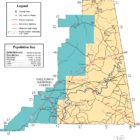
Cleburne County Alabama Gold Map
Cleburne County Alabama Gold Mines
Some of the most valuable placers in Alabama are found in Cleburne County. Waters in the Chulafinnee Mining District will all produce gold. Lode Mines are scattered throughout the county, with both copper and gold being the predominant metals.
Arbacoochee District
Anna Howe Mine
The Anna Howe Mines are thought to have produced the first gold-bearing quartz in Alabama. It made the county one of the most prolific producers of gold in the state.
Arabacoochee Placer
Arbacoochee Mine
Ayers Prospect
Ballinger Prospect
Bennifield Prospect
The Bennefield Property consisting of open cuts, low grade lode gold.
Carr Creek Placer
The Carr Creek Placer is 240 acres of clay and gravel that contains placer gold. Area watercourse gravels and sands contain placer gold.
Chulafinnee Placer
The Chulafinnee district adjoins the Arbacoochee district on the south by southwest areas. Along Chulafinnee Creek and its tributaries, the Chulafinnee placers, was gold rich gravels under 6 foot of overburden.
Clear Creek Lode and Placer
Creamer Mine (Reeves Shaft)
Crown Point Property Prospect
Crumpton Prospect
Crutchfield Mine
Denson Prospect
Eckles Mine
The Eckles Property consisted of 40 acres with 100 foot shaft in a quartz vein in decomposed schist.
Golden Eagle Mine (Price Mine)
Gold Ridge Mine
Head Mine
Hicks-Wise Mine
The Hicks-Wise Mine was 110 ft., deepest shaft in state, and the Lee Mine, quartz vein in slate, was rich lode gold deposit.
Higginbottom Prospect
Johnson prospect (Walker prospect)
King Mine
“Alabama King Mine” is a past producer vein deposit site in the Appalachian Highlands of Alabama, The United States. It is a small deposit, located in the Devils Backbone mining district and is not considered to be of world-class significance. The King Mine consisted of a pit of 2,500 square foot in schist laced with quartz veins and was the site of old stamp mill.
Alabama King Mine
“Alabama King Mine” is a past producer deposit site in the Appalachian Highlands of Alabama. It is a small deposit, not considered to be of world-class significance. The Alabama King Mine is near Jacksons’ Gap, Alabama. Historically the site has been part of the Devils Backbone Mining District.
The Alabama King Mine was closed at the time of data entry with no known plans to re-open. Mine operations consist of underground workings. There is one known shaft. Subsurface depth reaches a maximum of 30 meters (98 feet). The ore mined is composed of gold. The ore body is linear in form of unknown dimensions. The host rock in this area is schist from the Upper Cretaceous epoch 100.50 to 66.00 million years ago. The Piedmont Upland of the Appalachian Highlands characterize the geomorphology of the surrounding area.
Gold deposits are documented at “Alabama King Mine.” Gold is present at a grade sufficient to have a strong effect on the economics of an excavation project. It may even be viable as the only commodity mined.
This deposit has operated in the past as a production but was closed at the time it was surveyed. There were no known plans to reopen it. A underground operation was at this site or proposed for it.
The legend that swirls around the former King Mine, located about three miles west of Chulafinnee. The old mining region is contained in 300 acres now owned by Don Soleman.
According to a survey report in 1896, the Rev, Mr. King Mine (aka as the King Mine) “was reported to have been in operation with a stamp mill in the 1870s; however, work was abandoned due to litigation.”
(#USGS10184657), a gold mining deposit in Cleburne County, Alabama. Located on private property: 32.8668°N 85.8291°W
Lee Mine
Lucky Joe Mine (Moss-Back Mine)
Marble Pit Mine
Marion White Prospect
The Marion White Property was once a major source of rich specimen ore.
The Middlebrook Property
The Middlebrook Property is reported to have rich panning.
Miller Prospect
Moss-Back Mine
Prince Mine
Pritchet Mine (Pritchard Mine; Moss-Back Mine)
Reeves Shaft
Riddle Mine
Section 5 – Arbacoochee Mine
Striplin Placer
Sutherland Mine
The Sutherland Property was extensively worked and the site of a 10 stamp mill.
REF:Deposit:: ADAMS, G.I., 1930, GOLD DEPOSITS OF ALABAMA AND OCCURRENCES OF COPPER, PYRITE, ARSENIC AND TIN: ALABAMA GEOL. SURVEY BULL. 40, 91 P.
Deposit:: SPAINE, S.I., 1969, BASE-AND PRECIOUS-METAL AND RELATED DEPOSITS OF ALABAMA: ALABAMA GEOL. SURVEY CIC 55, P. 75.
Deposit:: PARDEE, J T & PARK, JR, C F, 1948, USGS PROF PAPER 213, P. 1
Commodities (Major) – Gold
Middlebrook Mine
Valdor Prospect
Wise Mine
Cleburne County Alabama Gold Mines
Arbacoochee Mining District
The mining district around Arbacoochee, roughly ten miles south of Heflin is composed of the rich placer gold-producing properties of Anna Howe, Marion White, Sutherland, Eckles, Pritchet, Crown Point and Middlebrook; the Golden Eagle (Prince) Mines; and many additional lode gold deposits as well.
Anna Howe Mine
The Anna Howe Mine is near Heflin, Alabama. Historically the site has been associated with the Arbacooche Mining District which is now part of the Talladega National Forest. The Anna Howe Mine was closed at the time of data entry with no known plans to re-open. Production size when active was considered to be small. Mine operations consist of underground workings. There is one known shaft. Subsurface depth reaches a maximum of 30 meters (100 feet). The ore mined is composed of pyrite and gold with waste material consisting primarily of quartz. The ore body is linear in form of unknown dimensions. The host rock in this area is phyllite from the Lopingian epoch 259.80 to 252.17 million years ago. The Piedmont Upland of the Appalachian Highlands characterize the geomorphology of the surrounding area.
Arabacoochee Placer
The Arbacoochee Placer Mines are near Heflin, Alabama. Historically the area has been associated with the Arbacooche Mining District which is now part of the Talladega National Forest. The Arbacoochee Placer Mines was closed at the time of data entry with no known plans to re-open. Production size when active was considered to be small. The Piedmont Upland of the Appalachian Highlands characterize the geomorphology of the surrounding area.
Arbacoochee Mine
The Section 5-Arbacoochee Mine is near Heflin, Alabama. Historically the site has been associated with the Arbacooche Mining District which is now part of the Talladega National Forest. The Section 5-Arbacoochee Mine was closed at the time of data entry with no known plans to re-open. Production size when active was considered to be small. The ore mined is composed of gold. The ore body is described as tabular shaped of unknown dimensions. Associated rock in this area is volcanic ash from the Upper Cretaceous epoch 100.50 to 66.00 million years ago. The Piedmont Upland of the Appalachian Highlands characterize the geomorphology of the surrounding area.
Ballinger Prospect
The Ballinger Gold Prospect is near Stroud, Alabama. Historically the site has been part of the Arbacooche Mining District. The ore mined is composed of gold. The mineralization at this location is from the Lopingian epoch 259.80 to 252.17 million years ago. The Piedmont Upland of the Appalachian Highlands characterize the geomorphology of the surrounding area.
Carr Creek Placer
The Carr Creek Placer is in Hollis Crossroads, Alabama. Historically the site has been associated with the Chulafinnee Mining District which is now part of the Talladega National Forest. The Carr Creek Placer was closed at the time of data entry with no known plans to re-open. Production size when active was considered to be small. The ore mined is composed of gold with waste material consisting primarily of quartz. The ore body is described as tabular shaped of unknown dimensions. The host rock in this area is sand & gravel. The Piedmont Upland of the Appalachian Highlands characterize the geomorphology of the surrounding area.
Clear Creek Lode and Placer
The Clear Creek Lode And Placer is near Hollis Crossroads, Alabama. Historically the site has been associated with the Arbacooche Mining District which is now part of the Talladega National Forest. The Clear Creek Lode And Placer was closed at the time of data entry with no known plans to re-open. Past operations took place from 1845 to 1907. Production size when active was considered to be small. The ore mined is composed of gold with waste material consisting primarily of quartz. The ore body is linear in form reaching 1,609.30 meters (5,279.86 feet) long and 0.15 meters (0.49 feet) thick. The host rock in this area is gravel from the Holocene epoch 11,784 years ago to present. The Piedmont Upland of the Appalachian Highlands characterize the geomorphology of the surrounding area.
Creamer Mine (Reeves Shaft)
The Creamer Gold Mine is near Heflin, Alabama. Historically the site has been associated with the Arbacooche Mining District which is now part of the Talladega National Forest. The Creamer Gold Mine is a underground mining operation. The ore mined is composed of gold. Associated rock in this area is volcanic ash from the Upper Cretaceous epoch 100.50 to 66.00 million years ago. The Piedmont Upland of the Appalachian Highlands characterize the geomorphology of the surrounding area.
Golden Eagle Mine (Price Mine)
The Golden Eagle Mine is near Hollis Crossroads, Alabama. Historically the site has been part of the Arbacooche Mining District. The Golden Eagle Mine was closed at the time of data entry with no known plans to re-open. Production size when active was considered to be small. The ore mined is composed of gold with waste material consisting primarily of quartz. The ore body extends 3 meters (10 feet) thick 22 meters (75 feet) below the surface. The host rock in this area is mica schist from the Lopingian epoch 259.80 to 252.17 million years ago. The Piedmont Upland of the Appalachian Highlands characterize the geomorphology of the surrounding area.
Johnson prospect (Walker prospect)
Lucky Joe Mine (Moss-Back Mine)
The Lucky Joe Mine is near Ranburne, Alabama. Historically the site has been part of the Arbacooche Mining District. The Lucky Joe Mine was closed at the time of data entry with no known plans to re-open. Production size when active was considered to be small. The Piedmont Upland of the Appalachian Highlands characterize the geomorphology of the surrounding area.
Marble Pit Mine
The Marble Pit is near Heflin, Alabama. Historically the site has been associated with the Arbacooche Mining District which is now part of the Talladega National Forest. The Marble Pit was closed at the time of data entry with no known plans to re-open. Production size when active was considered to be small. The ore mined is composed of gold with waste material consisting primarily of quartz. The ore body is linear in form of unknown dimensions. The host rock in this area is mica schist from the Lopingian epoch 259.80 to 252.17 million years ago. The Piedmont Upland of the Appalachian Highlands characterize the geomorphology of the surrounding area.
Pritchet Mine (Pritchard Mine; Moss-Back Mine)
Unnamed Gold Prospect (MRDS – 10081348)
Unnamed Gold Prospect (MRDS – 10081349)
This information is for reference purposes only. You should never attempt to visit any sites listed without first ensuring that you have the permission of the land and/or mineral rights holders and that you are aware of all safety precautions necessary.