
Contents
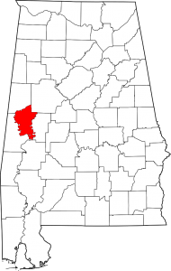
Greene County Alabama Map
Greene County Alabama population is 9,045. making it the least populous county in Alabama. Its county seat is Eutaw, Alabama.
Greene County was created by an act of the Alabama on December 13, 1819, from lands ceded to the federal government by the Choctaw Indian Cession of 1816. The county was named for Revolutionary War hero Nathaniel Greene, and the county seat, Eutaw, was named for the Battle of Eutaw Springs, in which Greene led his troops in the recapture of Charleston, South Carolina, from the British.
Comprising approximately 631 square miles, Greene County lies in the west-central area of the state. It is bounded to the north by Pickens County and Tuscaloosa County, to the east by Hale County, to the south by Marengo County, and to the west by Sumter County.
The Tombigbee River flows along the western border of the county, and its tributary, the Sipsey River Swamp flows along the northern border. Other tributaries of the Tombigbee, including Taylor, Brush, and Trussells creeks, also intersect the county. The Black Warrior River runs along the eastern border until it meets the Tombigbee at Demopolis, just below the southern tip of Greene County, in Marengo County.
Greene County Alabama Cities:
Eutaw
Greene County Alabama Towns:
Boligee, Forkland, Union
Greene County Alabama Communities:
Clinton, Crawford Fork, Jena, Knoxville, Mantua, Mount Hebron, Pleasant Ridge, West Greene
Greene County Alabama Historic Places:
- Anthony, David Rinehart, House (added 1982 – – #82002015)
307 Wilson Ave. , Eutaw - Boligee Hill (added 1982 – – #82002014) Also known as Myrtle Hall SE of Boligee , Boligee
- Braune, Gustave, House (added 1982 – – #82002016) 236 Prairie St. , Eutaw
- Carpenter, Capt. Nathan, House (added 1999 – – #99000793) Also known as Twin Oaks Plantation 2.5 mi. SE of Clinton , Eutlaw
- Cockrell, Samuel W., House (added 1982 – – #82001618) 210 Wilson St. , Eutaw
- First Presbyterian Church (added 1974 – – #74000411) Main St. and Wilson Ave. , Eutaw
- Greene County Courthouse (added 1971 – – #71000098) Courthouse Sq. , Eutaw
If you would like to become a sponsor, advertise a related location, service or vacation spot that would add to the usefulness of this site, please email us: staff@digitalalabama.com.
Greene County Courthouse
Greene County Alabama Sheriff
Greene County Alabama Jail
loading map - please wait...