Cherokee Indian
Muscle Shoals Alabama
|
Muscle Shoals is the largest city in Colbert County, Alabama. As of the 2010 census, the population of Muscle Shoals was 13,146. The estimated population in 2015 was 13,706
Digital Alabama (/article/native-american-tribes-alabama/cherokee-indian)
Muscle Shoals is the largest city in Colbert County, Alabama. As of the 2010 census, the population of Muscle Shoals was 13,146. The estimated population in 2015 was 13,706

Morgan County Alabama was created by an act of the Alabama Territorial General Assembly on February 6, 1818, preceding Alabama’s statehood by almost two years. The county was originally named Cotaco for a creek that flows through it.

Marshall County Alabama
is located in the northeast part of the state and lies between the major metropolitan centers of Huntsville to the northwest and Birmingham to the southwest. Comprising approximately 567 square miles, Marshall County is one of the five smallest counties in the state. The population is 93,019. Its county seat is Guntersville, Alabama. A second courthouse is in Albertville, Alabama. Marshall County Alabama History:
Marshall County was created by the Alabama legislature on January 9, 1836, from Cherokee land acquired in the 1835 Treaty of New Echota.
During The War Between the States.
Turkeytown Alabama
Turkeytown, also called Turkey’s Town, was a Native American settlement found in 1788 by the Chickamauga Cherokee chief, Little Turkey. It was the largest Cherokee town in Alabama – at one time it covered 25 miles along both banks of the Coosa River. Little Turkey built the settlement as a refuge for his people because of the ongoing hostilities between the Cherokee Indians and the whites. Turkeytown Alabama History
During the Creek War of 1813, specifically in October, the Red Stick Indians were planning an attack on Turkey Town, The Cherokee Chief at that time, Pathkiller, send word to Andrew Jackson for help. Jackson sent a detachment let by General James White.

Cullman Alabama
Cullman is a city in Cullman County. Cullman is located along Interstate 65, about 50 miles north of Birmingham and about 55 miles south of Huntsville. In the time before European settlement, the area that today includes Cullman was originally in the territory of the Cherokee Nation. Cullman Alabama History
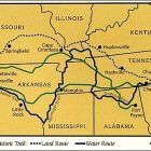
The region was traversed by a trail known as the Black Warrior’s Path1, which led from the Tennessee River near the present location of Florence, Alabama, to a point on the Black Warrior River south of Cullman. This trail figured significantly in Cherokee history, and it featured prominently in the American Indian Wars prior to the establishment of the state of Alabama and the relocation of several American Indian tribes, including the Creek people westward along the Trail of Tears.
Ft. Likens
Fort Likens was established at Barry Springs in northern Cherokee County. All Cherokee Indians including men, women and children living in the area surrounding the fort would have been rounded up and held there until they were sent to Fort Payne. Ft. Likens housed the federal troops responsible for rounding up the Cherokees on May, 24, 1838 and placing them in an internment camp located nearby at Barry Springs where they were held until they were transported to Indian Territory (present day Oklahoma) on the infamous Trail of Tears.

Colbert County Alabama is a beautiful area with a deep history dating back to the Cherokee and Chickasaw Indians and the early French traders around 1715. These early residents and settlers were attracted by the Tennessee River; the section in Colbert County earned the name “Muscle Shoals” because of the strength of the river in this area and the several different species of mussels. Colbert County has a population of 54,428. The county seat is Tuscumbia Alabama. Colbert County gets its name is in honor of brothers George and Levi Colbert, Chickasaw Indian chiefs.
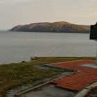
Waterloo Landing, located on Pickwick Lake (the former Tennessee River), was the site where, in July 1838, the 700-person Cherokee detachment led by Captain Gustavus S. Drane ended its 230-mile overland migration on the Trail Of Tears, boarded the steamboat Smelter, and left on the water route to Indian Territory. Here the party was united and set out on the eleventh aboard the steamboat SMELTER and two large double decked keel boats; the next afternoon they reached Paducah, Kentucky, where Lieutenant Deas left one of the keel boats which he found superfluous. He succeeded in mustering the Indians after a fashion and found that he had 489. (Grant Foreman, Indian Removal: The Emigration of the Five Civilized Tribes of Indians, Norman: Univ. of Oklahoma Press, 1956 (copyright 1932), p.291)
Captain G.S. Drane to Major General Winfield Scott — October 17, 1838
Cherokee Agency, Tennessee
17th October 1838
… on my arrival at Waterloo, Alabama I was ordered to muster the company out of the service, to discharge my teams & embark on board the Steamboat Smelter & proceed to Fort Gibson by the way of the Arkansas river, I believed that route unhealthy, & requested Gel Smith to allow me to take the route by Boonesville, Missouri, the route selected previous to the party’s leaving Ross’ Landing.