
Clay County Alabama
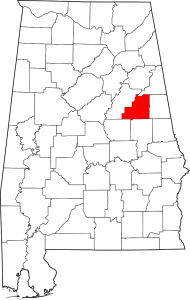
Clay County Alabama Map
Clay County population is 13,932. Its county seat is Ashland, Alabama. Its name is in honor of Henry Clay, famous American statesman, member of the United States Senate from Kentucky and United States Secretary of State in the 19th century.
Clay County was formed for geographic reasons. The citizens of the area had a difficult time reaching the county seat of Wedowee in Randolph County because of the Tallapoosa River to the east. Talladega was difficult to reach because of the intervening mountains. Even today, Clay County is one of only three counties in Alabama to have no U.S. Highways in its boundaries.
Cities: Lineville
Town: Ashland
Communities: Delta, Hollins, Millerville, Corinth, Cragford
Zip Codes: 36251
If you would like to become a sponsor, advertise a related location, service or vacation spot that would add to the usefulness of this site, please email us: staff@digitalalabama.com.
loading map - please wait...
Clay County was formed by an act of the Alabama General Assembly on December 7, 1866. Less than a year later, Ashland was established as the county seat on land donated by Hollingsworth Watts for the construction of a courthouse. Ashland was incorporated in 1871. Ashland, AL, United States | |
Lineville is located northeast of the center of Clay County at 33°18'45.122" North, 85°45'9.274" West (33.312534, -85.752576). The first white settlers in the area were William and Thomas Lundie. Their settlement became known as Lundie's Cross Roads after a trading post opened in the 1830s to serve pioneers and miners searching for gold. In 1856, Lundie's Cross Roads became known as County Line, probably for the Baptist Church, founded in 1848 and located on what was then the boundary line between Talladega and Randolph counties. Clay County formed in 1866. The town's name was officially changed to Lineville in 1870 when it became the temporary seat of government for Clay County. Lineville, AL, United States | |
 | The Talladega National Forest is located in the U.S. state of Alabama and covers 392,567 acres (613.39 sq mi, or 1,588.66 km2) at the southern edge of the Appalachian Mountains. talladega national clay county al |