Choctaw County Alabama
Choctaw County Alabama’s population is 13,859. Its county seat is Butler, Alabama. The county was established on December 29, 1847 and named for the Choctaw tribe of American Indians.
Towns: Butler, Gilbertown, Lisman, Needham, Pennington, Silas, Toxey
Communities: Cullomburg, Bladon Springs, Jachin, Melvin, Mount Sterling, Pushmataha, Spring Hill, Robjohn, Yantley
If you would like to become a sponsor, advertise a related location, service or vacation spot that would add to the usefulness of this site, please email us: staff@digitalalabama.com.
Choctaw County
loading map - please wait...
 | 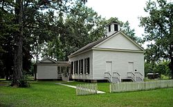 Mount Sterling Methodist Church is a historic Methodist church building near the junction of Choctaw County Road 43 and Choctaw County Road 27 in the rural community of Mount Sterling, Alabama. It is an almost unaltered example of the simple, Greek Revival style popular for rural churches in the mid-19th century. It was added to the National Register of Historic Places on May 8, 1986. Mount Sterling Alabama, United States of America |