Chilton County Alabama
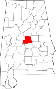
Chilton County Alabama Map
Chilton County population is 43,643. The county seat is Clanton. Chilton County was originally named Baker County when created in 1868 but was renamed in 1874.
The county is known for its peaches and its unique landscape. It is home to swamps, prairies and mountains due to the foothills of the Appalachians which end in the county, the Coosa River basin, and its proximity to the Black Belt Prairie that was long a center of cotton production.
Cities: Calera, Clanton, Jemison
Towns: Maplesville, Thorsby
Communities: Isabella, Jumbo, Mountain Creek, Stanton, Verbena
If you would like to become a sponsor, advertise a related location, service or vacation spot that would add to the usefulness of this site, please email us: staff@digitalalabama.com.
loading map - please wait...
Clanton population is 8,619. The city is the county seat of Chilton County. | |
Pingback: Blue Creek Alabama: Placer Gold Deposits | Digital Alabama | Alabama Tourism GuideDigital Alabama | Alabama Tourism Guide