
Etowah County Alabama
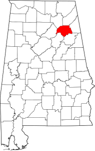
Map of Alabama highlighting Etowah County
Etowah County is a county of the U.S. state of Alabama. As of the 2010 census the population was 104,430.Its county seat is Gadsden. It is the smallest county in Alabama but one of the most densely populated.
The Alabama legislature established Etowah County on
December 7, 1866. In honor of the confederate soldier, General David W. Baine, Etowah County was originally named Baine County. Baine County officially became known as Etowah County on December 1, 1868.
Etowah County has 17 cities/towns of which Gadsden, Alabama is the county seat.
Our County is bordered by Marshall, DeKalb, Cherokee,
Calhoun, St. Clair, and Blount Counties. Sand Mountain, Lookout Mountain,
and Noccalula Falls are just a few of the attractions found here.
Get In Touch
Quick Links
Cities: Attalla, Boaz, Gadsden, Glencoe, Hokes Bluff, Rainbow City, Southside
Towns: Altoona, Reece City, Ridgeville, Sardis City, Walnut Grove
Communities: Ballplay, Bristow Cove, Carlise-Rockledge, Coasts Bend, Egypt, Galland, Ivalee, Lookout Mountain, New Union, Owassa, Tidmore Bend, Whitesboro, Anderson, Liberty Hill, Pilgrims Rest, Mountainboro
If you would like to become a sponsor, advertise a related location, service or vacation spot that would add to the usefulness of this site, please email us: staff@digitalalabama.com.
loading map - please wait...
 | Ballplay was so named because Native Americans would play a ball game at the site in order to resolve disputes between tribes. A post office was established at Ballplay in 1840, and remained in operation until it was discontinued in 1905. Ballplay, AL, United States |
Hokes Bluff is a city in Etowah County, Alabama, United States. It is part of the Gadsden Metropolitan Statistical Area. At the 2000 census the population was 4,149 and 4,286 in 2010. Hokes Bluff was established on a high bluff overlooking the Coosa River. The town was called "The Bluff", and was used as a lookout station for Native American tribes, as they could a great distance across, up and down the Coosa River. Hokes Bluff was one the staging areas where the Cherokee were collected, and sent to Gunter's Landing (Guntersville), and west to Oklahoma on the Trail of Tears. Settlers came into the area in the 1840s. Daniel Hoke Jr. was among the settlers, who came in 1850 and built a trading post and a blacksmith shop near the site of the bluff. The town was renamed Hoke's Bluff after him in 1853 by W.B. Wynne, a friend of Hoke. The town was raided and pillaged during the Civil War by raiding parties of both sides of the Union and the Confederacy. John Henry Wisdom, who became the "Paul Revere of the Confederacy" after making his famous ride from Gadsden to Rome during the Civil War was a resident of Hokes Bluff. | |