Ghost Towns of Alabama
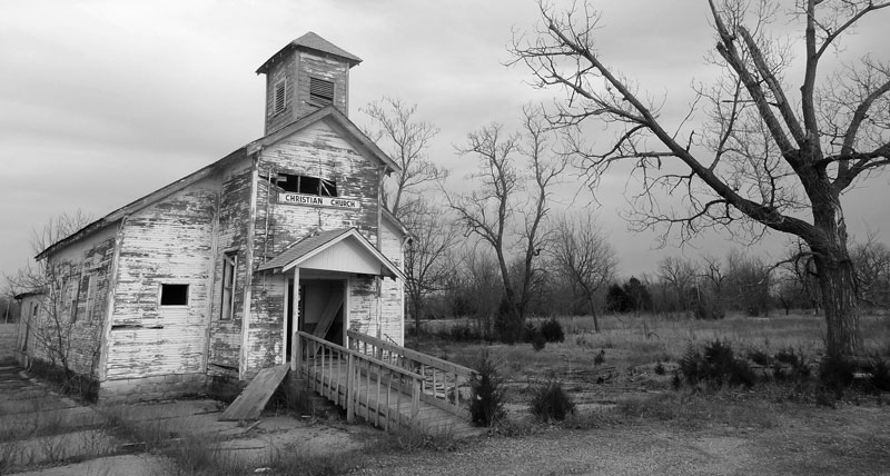
Adamsville Alabama
Residents report dark figures moving around the woods on the outskirts of their neighborhoods. Some say they can feel or even hear someone following them, but turn around to find that no one is there.
Aigleville Alabama
Aigleville Alabama, literally translated as Eagle Town, was a town on the Black Warrior River in Marengo County, Alabama.
Arbacoochee Alabama
Arbacoochee, in Cleburne County, was the site where gold mines were found in the 1830’s. Less than 15 years later, it was bursting at the seams with 5,000 residents. Reportedly, the Arbacoochee business district included 20 general stores, hotels, saloons, and of course, stores where miners could purchase equipment.
The town started its decline when miners left for the California gold rush. Although there was still mining in Arbacoochee until the 1930’s, there was no resurrection, and it was empty by 1990. A once bustling mining camp, it is now another Alabama ghost town with little to show for the rich gold that was once so abundant there.
Arcola Alabama
Arcola Alabama is a ghost town on the Black Warrior River in what is now Hale County, formerly Marengo County, Alabama.
Barnsville Alabama
Located off highway 19 in Marion County, Alabama. Information indicates there was a grocery store, blacksmith shop and two churches.
Battelle Alabama
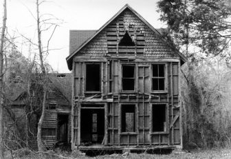
abandoned-house-in-battelle-alabama
Battelle is a ghost town in DeKalb County, Alabama. Battelle was once a thriving mining community which was spread in a north – south line along the foot of Lookout Mountain five miles north of Valley Head, Alabama.
At the beginning of the 20th century, Battelle included hundreds of houses, a school, a commissary, a hotel and post office, in addition to the furnace and coke ovens. Battelle had a water system with water from a spring that was pumped into a large wooden tank and then piped into the surrounding homes.In the late 19th century, a group of miners from the northern state of Ohio discovered limestone, ore, and coal on what was later named Battelle, Alabama. The Lookout Mountain Iron Company was a boon to the town’s economy for years but by 1905, pig iron ingredients of higher quality were found in Birmingham, Alabama.
The stiff competition forced the Lookout pig iron furnace operations to be put on hold. Later, the federal government purchased the company and it was moved from the area. No buildings remain in Battelle and it remains an Alabama ghost town.
Beaver Mills Alabama
Beaver Mills, in Mobile County, Alabama, is also known as Beaver Meadow. It was the location of a large paper mill. During the Civil War, the mill was used as a clothing depot. When the war ended, the clothing was used to make bonded paper. The site is just off U.S. Route 45, south of Citronelle. It was the site of a paper mill that was also used as a uniform depot during the American Civil War. A post office operated under the name Beaver Meadow from 1890 to 1906.
What’s left of Beaver Mills is the skeleton of the paper mill deep within the woods which have claimed the town. The property is privately owned; the mill cannot be viewed up close without owner permission.
Bellefonte Alabama
Bellefonte was the county seat of Jackson County in the years 1821-1859. However, the Civil War left it damaged to the extent that it was never able to recover. By the 1920’s Bellefonte was totally abandoned. Today, the only testaments to the town are the cemetery and the tall creepy chimney of the inn, which is mostly overgrown with vines.
Blakeley Alabama
Blakeley is a ghost town in Baldwin County, Alabama. During the height of its existence, Blakeley was a thriving town which flourished as a competitor to its western neighbor, Mobile, Alabama. It was the location of a major fort during the Civil War. One of the last battles of the civil war was fought here as Union soldiers overran Confederates. The town is now in an Alabama historic state park known as Historic Blakeley State Park near Spanish Fort, Alabama.
Bluffton Alabama
Bluffton is an unincorporated community in Cherokee County. Bluffton was founded as a mining community in 1888. In 1890, Bluffton was home to approximately 8,000 residents. The Bluffton Land, Ore and Furnace Company operated an iron mine in the area, and was also responsible for building the Signal Hotel, which at one point hosted Rudyard Kipling. The Signal Hotel was the first structure in Cherokee County with electric lights. Bluffton had one newspaper, the Bluffton Mascot, and was home to a Methodist Episcopal church and Salem Baptist Church, which is still in use today.
Besides the iron mines, Bluffton was home to a water works system, school, post office, and Cherokee County’s first electrical generating plant. Even so, Bluffton’s ore fields did not meet the expectations of their investors and higher grade iron was available closer to Birmingham. Commercial businesses began to fail, and Bluffton soon came to be considered a ghost town.
A post office was operated in Bluffton from 1888 to 1934.
| Coordinates: 34°00′25″N 85°26′24″W |

Bootsville Alabama
Bootsville is a ghost town in the Sand Valley area of central DeKalb County. It was located roughly five miles west-southwest of Fort Payne. This would place it near the present-day intersection of County Road 458 and County Road 461.
Though it once held the distinction of being the county seat of DeKalb County, very little is known about Bootsville. In 1837, the county seat moved to the town from Rawlingsville, making it the county’s second seat of justice. However, Bootsville was only the county seat for a matter of months before the town of Camden assumed this role in 1838. This was around the time the county was still being organized. Bootsville was named for an Indian chief named Boots, who lived in the vicinity.
Brownville Alabama
Brownville, also known as Brownsville, Hog Eye, Red Valley, and Sulpher Springs, is a ghost town formerly located in Tuscaloosa County.
The community was originally called Sulpher Springs, named for the nearby mineral springs. Later known as Hog Eye due to its small size, then known as Red Valley for the fact that most houses in the community were painted red. Finally known as Brownville in honor of W. P. Brown. In addition to the Brown Lumber Company, the Brown Wood Preserving Company was also located in Brownville. A post office operated under the name Brownville from 1926 to 1966, and Brownville Rural Station from 1966 to 1972.
Cahaba Alabama
Cahaba, in Dallas County, was the first capitol in the state of Alabama. The town was laid out in 1819 and a busily functioning capitol city by 1820. Within five years, it became obvious that Cahaba was not the ideal location for the state capitol. The low-lying city sat near two rivers that flooded quite often. The first flood in 1825 was so major that it caused part of the statehouse to collapse.
There are several buildings within Cahaba’s city limits that are still intact today, including its Civil War federal prison and a farmhouse built in 1841, although it is long uninhabited.
Cedric Alabama
Cedric, Alabama was a small community in northeastern Chambers County, Alabama. Today it is entirely in private ownership. It is located 3–4 miles to the southeast of present day Roanoke, Alabama and about 1 mile southwest of Bacon Level Church.
Choctaw Corner Alabama
Choctaw Corner was a former town in Clarke County. It is named for the nearby Choctaw Corner, which marked the border between the native Choctaw and Creek peoples prior to the Indian removal. The community was one of the earliest settlements in the county.
Choctaw Corner slowly declined into nonexistence and was later enveloped within Thomasville Alabama’s city limits. It is now remembered primarily by Thomasville’s city cemetery on its western border, called Choctaw Corner Cemetery.
Chulafinnee Alabama
Chulafinnee was originally one of several Indian villages of the Upper Creek Nation.The Indian word, Chulafinnee, means “Pine Log Crossing.” Chulafinnee is now a ghost town with a gold producing past. It is located in the southwest corner of Cleburne County along Carr & Chulafinnee Creeks.
Claiborne Alabama
Claiborne Alabama is a ghost town on a bluff above the Alabama River in Monroe County, AlabamaSituated near the Federal Road, Claiborne began during the Mississippi Territory period with a ferry over the river.
Clarkesville Alabama
Clarkesville (also spelled Clarksville) is a ghost town in Clarke County, Alabama. It was the county seat of Clarke County until 1831.
Deer Park Alabama
Deer Park is an unincorporated community and census-designated place in Washington County. Although a ghost town by 1966 it had a population of 188 at the 2010 census. Deer Park is 17.5 miles south-southwest of Chatom. Deer Park has a post office with ZIP code 36529.
Erie Alabama
Erie is a ghost town located in present-day Hale County. This was formerly the county seat of a larger Greene County, but the seat was moved to Eutaw in 1838 for the benefits of a more central location in a developing frontier area.
Erie declined without the benefit of county government business. When Hale County was organized in 1867, after the Civil War, Erie was within its boundaries. It was effectively abandoned long before the last house burned down in 1933
Located at the “Erie Bend” on the east bank of the Black Warrior River, the former settlement is approximately 11 miles east of Greensboro.
Fort Mims
Four miles west of Tensaw, Alabama. Built by settlers in 1813, more than 100 houses surrounded the fort. It was attacked by Indians and all but 36 of the 500 area residents were massacred by the Creek Indians who burnt the fort and houses to the ground.
Gantts Quarry Alabama
Gantts Quarry, in Talladega County, was incorporated in 1910 after the discovery of white marble by Dr. Edward Gantt in 1830. One block of this marble is part of the construction of the Washington Monument. Gantts Quarry demise was caused by a steady decline in population as the demand for marble in building construction declined in the 1930’s post Great Depression era. At that time Gantts County had 542 residents. Over time, all citizens relocated to other towns. The 2000 Census recorded Gantts Quarry as having zero population.
The first recorded discovery of marble was in 1820 by Dr. Edward Gantt, a physician who had accompanied General Andrew Jackson through the area in 1814. Even Gantt probably did not realize the extent of this calcium carbonate deposit. The deposit is part of the “Murphy Marble Belt” extending 321/2 miles wide by 400 feet deep and is the world’s largest commercial deposit of madre cream marble.
In the 1830’s, several quarries were opened in Talladega County and perhaps one in neighboring Coosa County. Using the old Plank Road, they made shipments throughout Central Alabama. By 1906 New York interests had bought Gantt’s Quarry from its Ocala investors, and this site emerged as the center of marble-working activity. An elite town actually developed in and around this property, later called the Alabama Marble Company.
By the turn of the century, Sylacauga quarries had an established reputation; and shipments were being made throughout the state. Although structural marble was being produced to some extent, a very lucrative use of marble was found in the steel industry. More and more of the Sylacauga deposits were being blasted and used for fluxing steel. Later dolomite replaced marble in this process.
Credit: The Marble Industry In Sylacauga
Failetown Alabama
Today the only thing that remains of the town is the Faile Cemetery which contains the graves of the Faile, Mott and Agee families.
Fort Stonewall
Located in Clarke County, Fort Stonewall was a Civil War Site located on the west bank of the Alabama River between the Alabama and Tombigbee Rivers.
Kaulton Alabama
Kaulton was founded in 1912 to serve as the location for Kaul Lumber Company’s new mill after the mill in Hollins, Alabama closed. Kaulton had houses for workers, a hotel, churches, a school, parks, and offices. The entire complex covered over eighty acres.
Louina Alabama
Located in Randolph County, originally settled by Creek Indians and defeated in the Battle of Horse Shoe Bend by Andrew Jackson. It is named for an Indian woman who ran a trading post some years after it was taken over.
During the Indian Relocation Act, it is said, Louina was among the Native Americans forced to leave. The tale goes on to say that she buried silver and gold in Louina before she left, but not before putting a curse on the town, swearing that it would cease to exist. Over time, the very prosperous town began a downward spiral until it vanished along with most of its history.
The descendants of the foundling settlers of the city are currently working to preserve the site.
Manasco Alabama
Located in Walker County. Population unknown. Located on 160 acres owned by David C. Manasco. The town exixted from about 1879 to 1900. A Post Office existed from 24 Jul 1879 to 5 Feb 1889 with Mrs Elizabeth A. Palmer as Postmaster.
Minden Alabama
Located in Calhoun County, Minden post office existed from 1878 to 1879.
| Latitude: | 33.702323 |
| Longitude: | -86.106084 |
Morrison Alabama
On RR, five miles SE Rabun, Alabama.
From The Atlanta Constitution, Atlanta, GA 22 March 1913:
Morrison, AL Tornado, Mar 1913
The little town of Morristown, Ala., on the Louisville and Nashville, north of Mobile, was hard hit by the same tornado which wrecked the town of Lower Peachtree yesterday, according to belated advices received here this morning. The big plant of the Hall-Leftwich Lumber company was practically demolished by wind, and eight houses wrecked. There were no fatalities, through several people were injured.
The Atlanta Constitution, Atlanta, GA 22 Mar 1913
Mountain Hills Alabama
Old Ramer Alabama
Existed untill about 1895. A small town with a sugar mill, hotel, general store, blacksmith shop. creeks and wells. A hub for Ramer until new roads came and mill closed. Old hotel and mill was old stage coach route. From Montgomery take 231 south to Goodwin Rd, follow till cemetary.
Now on private property.
Pansey Alabama
Pansey, in Houston County Alabama, was a very vibrant farming community in the late 1800s and early 1900s. It was incorporated in the late 1800s and was named after the first postmaster’s daughter. At one time there were several stores, a feed mill, a cotton gin, a two-storey school house and a doctor. No longer incorporated. Some long time residents still remain but very little population. There is a volunteer fire department. The railroad also made a stop in Pansey and Pikeville.
Pikeville is a ghost town in Marion County, Located on US Hwy 43 between Hamilton and Guin. It sits on a ridge along the path of General Jackson’s circa 1812 Military Trail.
Pikeville served as the first permanent county seat of Marion County from 1820-1882. It was incorporated as a town on January 12, 1827. The county courthouse was destroyed by fire in 1866, and was later rebuilt.
Pikeville was gradually abandoned when the county seat was moved to Hamilton in 1882. The community cemetery remains south of Marion County Road No. 2. The two-story home east of the highway was the courthouse of the 1820’s where two original benches are yet preserved. The house was modified to become the home of Probate Judge John Dabney Terrell in 1859. Court House Square was located north of the Terrell home and family cemetery. Both are located along Jackson’s Military Road.
| Coordinates: 34°02′17″N 87°57′04″W |
Pleasant Gap Alabama
Pleasant Gap, in Cherokee County, gets its name from its location in a “gap” of Frog Mountain. Pleasant Gap was once a town surrounding a grist mill just a few miles from the mining town of Rock Run. A post office was established in 1847, according to a 2004 article in The Calhoun Times. The post office operated until 1932.
Praco Alabama
Praco, in Jefferson County, was once bustling with miners who pulled coal from the earth for the Pratt Consolidated Coal Co., from which the town’s name was derived.
Prairie Bluff Alabama
Prairie Bluff, also known as Dale and Daletown, is a ghost town in Wilcox County, Alabama. Prairie Bluff first appeared on maps in 1819, the same year that Alabama was admitted to the Union as a state. It was listed erroneously as Prairie Blue on Fielding Lucas’ Geographic, Statistical, and Historical Map of Alabama, printed in Philadelphia in 1822. However, another of Lucas’ Alabama maps, also printed in 1822, lists it as Prairie Bluff. It is interchangeably listed as Dale, Daletown, or Prairie Bluff on subsequent maps from the 1830s until the mid-1850s, after which time Prairie Bluff is the only name used. It disappeared from maps altogether around 1900.
Red Apple Alabama
Red Apple is a ghost town in Marshall County, Alabama.A post office called Red Apple was established in 1870, and remained in operation until it was discontinued in 1903. The community was named from an apple orchard near the town site.
Riverton Alabama
Riverton, located in Colbert County, Alabama, was an old trade town that was destroyed when the Pickwick Landing Dam was built during the 1930s. It’s now underwater and the only remnant left of the town is a cemetery.
Robinson Switch Alabama
Rural area between Lowndesboro, Alabama and Montgomery, Alabama named by locals as Robinson or Robinson Switch. Follow the dirt lane located at the crossroads of Lowndes County Road 29 and Lowndes County Road 40. Railroad tracks run alongside the backs of the surviving buildings, parallel to the dirt lane called Robinson Switch Road.
Library Of Congress Photos From The County Road 29 Area


Historic American Buildings Survey W. N. Manning, Photographer, Feb. 3, 1934. FRONT VIEW. - Howard House, State Highway 97 (County Road 29), Lowndesboro, Lowndes County, AL


Rock Run Alabama
Rock Run, in Cherokee County, was a town that grew around the Rock Run Mine and Furnace. According to a 2004 history in The Calhoun Times, “An iron foundry was destroyed by the Union army during the Civil War but was rebuilt around 1879. The post office established in 1883, first was called Bass, probably after the operator of the foundry.”
Ruthven Alabama
Ruthven is a ghost town in Wilcox County, Alabama. It was formerly a lumber town in the early 20th century, and was incorporated in 1924. It was located about 3 1/2 miles southwest of Pine Apple on Bear Creek along the Selma to Flomaton branch of the Louisville & Nashville Railroad, what is now County Road 2.
In 1930, it had 523 residents, making it the second largest town in Wilcox County after the county seat of Camden. Shortly afterwards, the town either disincorporated or lost its charter and rapidly declined. Very little exists of the town today as most of its buildings were dismantled. A post office was also located at Ruthven for a time.
Nearby to Ruthven was the community of Schuster, which was once the location of the Wilcox Mineral Springs Resort
Scrange Alabama
No records found. Supposedly located in the NE corner of Baldwin County, 5 miles SE Blakely.
Suspension Alabama
Suspension is a ghost town in Bullock County. The settlement began as an ancient Muscogee village called “Chananagi”.
The name “Suspension” derives from the temporary suspension of railroad construction at the settlement. The Mobile and Girard Railroad incorporated in 1849 and began laying a track southwest from Phenix City, Alabama. By 1852–53, the grading of the railroad bed had been completed to Union Springs, located 9 mi southwest of the settlement, however, by 1858 the laying of track had only been completed to a location known as “Stewarts Mill” because extensive excavations were required to complete the track from Stewarts Mill to Union Springs. Because the track laying was temporarily suspended at Stewarts Mill, the location became known as “Suspension”. The track was finally completed to Union Springs in 1859–60.
Bullock County Road 40 crosses the now-abandoned railway at Suspension, though nothing remains of the settlement.
Tooktocaugee Alabama
Tooktocaugee was an unincorporated community in Calhoun County. Tooktocaugee was formerly the site of a Creek Indian village. Coordinates: 33°41′35″N 85°41′55″W
Turkey Town Alabama
Turkey Town is a ghost town in Cherokee County. The community grew up around the Cherokee town Turkeytown. A post office called Turkey Town was established in 1828, and remained in operation until it was discontinued in 1861. The community was named after the village, which was named in honor of the Cherokee chief Little Turkey.
Vienna Alabama
Vienna was a prosperous river port from the 1830s until the American Civil War, situated along the eastern shore of the Tombigbee River on the southwestern border of the county.
Washington Alabama
Washington, Alabama is a ghost town located in Autauga County, Alabama on the north bank of the Alabama River, just west of the mouth of Autauga Creek.
Ghost Towns of Blount County Alabama
You May Also Be Interested in Alabama Haunted Places