Category: Alabama Maps
Alabama Maps
Our investigators and journalists locate and study a huge assortment of maps for a multitude of reasons. We are often employed to verify dates, ownership, geographic features and other matters which can be supported by old family documents and historical official government documents which may include deeds, drawings, sketches and of course, maps.
We also create our own digital maps for various uses. When possible, we like to share all maps and documents with you. Most of the time they will be published without explanation of what we were looking for but they may prove of interest to you.
We have created maps of all Alabama counties and several special purpose maps including a large selection of maps related to Native Americans in Alabama. You can find our maps by searching for them by name and we try to keep the Alabama Maps Index current so check it first.
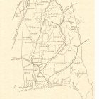
Early Roads and Routes in Alabama circa 1800-1839
Some of the early roads and routes shown are Natchez Trace, Gaines Road, Jackson’s Military Road, Huntsville Road, Post Road From Natchez, Old Federal Road, Pensacola Road, and Jackson’s Route to the Creek Wars.
Continue reading
Alabama Civil War Sites Map
Civil war battles and skirmishes mapped and notated.
Continue reading
Alabama South-East Region
Alabama South East Region Barbour County Barbour County is located in the southeastern section of the state, bounded on the east by
Continue reading
Alabama Treasure Map
Alabama treasure map marks the approximate location of the treasure legends researched. Keep in mind that most, if not all, of these legends and tales of burried treasure are nothing more than legend without any hard evidence whatsoever.
Continue reading
Alabama Haunted Places Map
Alabama has some of the most gruesome and terrifying of haunted places.
Would you dare venture to any one of these?
Autauga County Alabama Map
Explore Autauga County Alabama Maps
Continue reading
ALABAMA CAMPGROUNDS MAP
ALABAMA CAMPGROUNDS MAP
Continue reading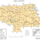
Lee County Alabama Map
Lee County Alabama is a county located in east central Alabama. As of the 2010 census the population was 140,247. The county seat is Opelika, and the largest city is Auburn.
Continue reading
Civil War Map: Siege operations at Spanish Fort
Siege operations at Spanish Fort, Mobile Bay, by the U.S. forces under Maj. Gen. Canby : captured by the Army of West Miss. on the night of April 8 & 9, 1865
Continue reading
Civil War Map: Selma Alabama and Vicinity
Shows fortifications. Relief shown by hachures. Printed on blue paper. Mounted on paper. In pencil in top right hand corner: 1864, 61. Pencil notes in right margin. LC Civil War maps (2nd ed.), S17, 111
Continue readingRebel Line of Works at Blakely
Rebel line of works at Blakely captured by the Army of West Miss., April 9, 1865. Union positions are colored blue, and Confederate works are red. Includes roads, vegetation, drainage, and relief by hachures.
Continue readingMap: Mobile County Alabama Historical Locations Map
Mobile County Alabama Historical Locations Map
Continue readingHaunted Places in Alabama Map
Haunted Places in Alabama Map See our Alabama Haunted Places Index
Continue readingMap: Alabama 1826
1826 Alabama Map
Relief shown in hachures. Prime meridian: Washington. From: A general atlas, Fielding Lucas, Baltimore, 1826.
Contributor: Lucas, Fielding
Date: 1826
Map: Mississippi Territory 1798 – 1817
Mississippi Territory 1798 – 1817 Map
Continue readingMap: 1859 Alabama
Map: 1859 Alabama
Continue readingMap: Madison County Alabama 1875
Map of Madison county, Alabama in 1875.
Relief shown by hachures.
Shows cities, towns, roads, geographical features, and landowners’ names.
LC copy imperfect: Torn, soiled, missing edge sections, mounted on cloth backing.
Includes note and ill. of buildings “Huntsville [S?]pring” and “Court House.”
LC Land ownership maps, 4

Shoal Creek Ranger District Recreation Map
Talladega National Forest -Shoal Creek District, 45 Highway 281, Heflin, AL (256-463-2272)
Continue readingBaldwin County Alabama Map
Baldwiin County Alabama map.
Continue reading