Birmingham Alabama Map
Birmingham Alabama map
Continue readingEXPLORE ALABAMA – For Adventure-Spirited Souls Looking for Something A Little Bit Different.
Our investigators and journalists locate and study a huge assortment of maps for a multitude of reasons. We are often employed to verify dates, ownership, geographic features and other matters which can be supported by old family documents and historical official government documents which may include deeds, drawings, sketches and of course, maps.
We also create our own digital maps for various uses. When possible, we like to share all maps and documents with you. Most of the time they will be published without explanation of what we were looking for but they may prove of interest to you.
We have created maps of all Alabama counties and several special purpose maps including a large selection of maps related to Native Americans in Alabama. You can find our maps by searching for them by name and we try to keep the Alabama Maps Index current so check it first.

Birmingham Alabama map
Continue readingNational Parks In Alabama Horseshoe Bend National Military Park Little River Canyon National Preserve Natchez Trace Parkway Russell Cave National
Continue reading
Lakes in Alabama are numerous. Alabama has no large natural lakes, but dams built on the abundant rivers have created many artificial lakes.
Continue readingBankhead National Forest Recreation Map
Continue readingWilliam B. Bankhead National Forest is covered by the Houston, AL US Topo Map quadrant
Continue reading
Digital Alabama created map showing locations of gold related areas we have studied. Contains mostly historic notes.
Continue reading
1839 map of Alabama and Georgia showing post offices, post roads, canals, railroads, etc
Continue readingMap La Louisiane Hand colored. Relief shown pictorially. From the author’s Grosser atlas … [1734?] Includes historical notes and inset
Continue reading
One of the oldest cities in the United States, Mobile is the seat of Mobile County in the southwestern corner of Alabama along Interstate Highway 10, on the banks of the Mobile River.
As a port city, its influences were shaped by the varied cargoes and exotic travelers that constantly passed through.
Continue reading
Manuscript Map of Southwestern Jefferson County, Unpublished, c.1888; for the Louisville and Nashville Railroad
Continue readingAlabama Counties and County Seats Map and List
Continue readingPortion of a 1911 Alabama map by Rand McNally. Locations shown include: Alameda, Allenm Alma, Atkeison P.OI., Atkinshon, Barlow Ben;d, Bashi, Campbell, Carlton, Chance, Chilton, Choctaw Bluff, Clarksville, Cobbville, Coffeeville, Damon, Dickinson, Eustis, Forestdale, Fulton, Gainestown, Glendon, Glover, Gosport, Grovehill, Jackson, Manila, McEntyre, Moirvin, Nealton, Nettleboro, Nichola, Opine, Peachock, Pouncey, Pugh, Rockville, Rural, Salitpa, Scyrene, Suggsville, Suggsville Station, Tallahatta Springs, Tattilaba, Thomasville, Walker Springs, West Bend, Whatley, Winn, Woodbluff
Continue readingAbout this Item Title Morse’s North American atlas. Other Title Morse’s cerographic maps Contributor Names Morse, Sidney E. (Sidney Edwards),
Continue reading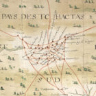
Detail of Baron de Crenay’s 1733 map of French colonial Louisiana, showing Indian trails (in red) in the area that would later become southwestern Alabama (courtesy of the Centre Historique des Archives Nationales, Paris).
Continue readingMap: Battle of Horseshoe Bend Date 5 November 2015, 11:45:25 Source The Pictorial Field Book of the War of 1812 Author Benson Lossing
Continue readingMap: General Jackson’s Campaign Against the Creek Indians 1813 and 1814
Continue reading
Indian Villages in Alabama ALABAMA INDIAN VILLAGES, TOWNS AND SETTLEMENTS INDEX PAGE Alabama has been the home of indigenous
Continue reading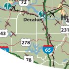
Alabama Maps Index In addition to our collection of historical maps, we have created maps of some Alabama counties
Continue readingThis image is a map of eastern section of North America showing the establishment and growth of British, French, and Spanish settlements up to 1760.
Continue readingTalladega Ranger District Recreation Map
Continue readingPerspective View of Montgomery, AL, ca 1887
Continue reading