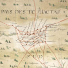
Map: 1733 map by Baron de Crenay (“Concha”) Posted on April 13, 2020April 13, 2020 by Staff 1733 map by Baron de Crenay (“Concha”) Return to Alabama Maps Index Detail of Baron de Crenay’s 1733 map of French colonial Louisiana, showing Indian trails (in red) in the area that would later become southwestern Alabama (courtesy of the Centre Historique des Archives Nationales, Paris).