JACKSON COUNTY ALABAMA
Jackson County Alabama

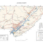
Jackson County Alabama is a county in the Northeast corner of Alabama. The population is 53,227 and the county seat is Scottsboro, Alabama.
Jackson County was named for Andrew Jackson, general in the United States Army and afterward President of the United States of America.
Jackson County Alabama Cities:
Bridgeport Alabama
Bridgeport is a city in Jackson County. At the time of 2010 census the population was 2,418, down from 2,728 in 2000.
Scottsboro Alabama
Scottsboro is a city in Jackson County. As of the 2010 census, the population of the city is 14,770. Named for its founder Robert T. Scott, the city is the county seat of Jackson County.
Stevenson Alabama
Stevenson City Hall is located on 104 Kentucky Avenue. Stop by City Hall for any information you may need about our Park, Depot, Library, Fort Harker, or anything else you may need to know.
Jackson County Alabama Towns:
Dutton Alabama

Dutton is a town in Jackson County. It was incorporated in 1963. As of the 2010 census, the population of the town was 315, up from 310 in 2000. Dutton is located atop Sand Mountain.
Hollywood Alabama
Hollywood is a town in Jackson County. As of the 2010 census, the population of the town was 1,000, up from 950 in 2000. Hollywood is considered a suburb of Scottsboro, the county seat. The town is the site of the Tennessee Valley Authority’s never-completed Bellefonte Nuclear Generating Station.
Originally established as Samples on December 14, 1883, the town was renamed as Hollywood on May 13, 1887. It formally incorporated on May 24, 1897, and held its first election June 8 of that year.
Hytop Alabama
Hytop is a town in Jackson County. It incorporated on May 17, 1991. As of the 2010 census, the population of the town was 354, up from 315 in 2000. The Walls of Jericho, a popular hiking area, is located just north of Hytop.
Langston Alabama
Langston is a town in Jackson County. As of the 2010 census, the population of the town was 270, up from 254. Langston initially incorporated in 1899.
Paint Rock Alabama
Paint Rock was settled in the 1820s, and was initially known as “Camden.” A post office was established in 1836, and a railroad depot was constructed in 1856. The name was changed from Camden to “Paint Rock” in 1876.
Paint Rock is a town in Jackson County, along the Paint Rock River. It was incorporated in July 1894. As of the 2010 census, the population of the town was 210, up from 185 in 2000. As of the 2010 census, the population of the town was 210, up from 185 in 2000. This was the first time in 100 years it increased in population. Out of 13 incorporated communities in Jackson County, it is the least populated. Its peak population was in 1910 when it had 534 people and was the 4th largest town in the county.
Pisgah Alabama
Pisgah is a town in Jackson County, Alabama. Pisgah was first settled in the late 1830s. The first white settlers began to move to the Pisgah area after Indian Removal in 1836, mainly during the 1840s-1850s. A post office was established in 1878, and the community was named for Mount Pisgah, the mountain in the Bible from which Moses viewed the Promised Land. It is included in the Huntsville-Decatur Combined Statistical Area. It incorporated in 1947. As of the 2010 census, the population of the town was 722, up from 706 in 2000. Pisgah is located atop Sand Mountain.
Pleasant Groves Alabama
The town is situated on a narrow ridge that extends outward from the Cumberland Plateau in western Jackson County. Woodville lies at the base of the plateau to the southwest, Skyline lies along the plateau to the northeast, and the Paint Rock River flows through the valley to the northwest. County Road 8 is the primary traffic artery in Pleasant Groves.
Section Alabama
Section is located on land where the Cherokee once hunted and lived. The community was originally known as Mt. Zion when the first post office was established. There were communities such as Kirby’s Creek, Gossets Hollow, and Fern Cliff. These communities came together to form the Town of Section. Pioneer settlers came in 1862 to Section, in large numbers. Settlers were required to live on the land for five years before claiming the property as their own. It became known later as “Section” because it was the location of a square-mile parcel of land, known as the 16th Section, required by the federal government to be set aside in support of public schools.
As of the 2010 census, the population of the town was 770, an increase of one person from 2000. Section is located on top of Sand Mountain.
Skyline Alabama
Skyline began in 1934 as a cooperative farming experiment known as “Cumberland Farms” under President Franklin Roosevelt’s Federal Emergency Relief Administration. This was one of 43 such projects attempted nationally in depressed areas. It was soon renamed “Skyline Farms” to avoid confusion with another project in neighboring Tennessee. The experiment lasted for a decade before being sold off to private buyers in 1944.
The current town of Skyline is located about a mile north of the original farming colony.
Woodville Alabama
Woodville was settled about 1815 by Henry Derrick and is the oldest town in Jackson County. It was named for early residents Richard and Annie Wood. Woodville became the seat of Decatur County, Alabama in December 1821, but was attached to Jackson County when Decatur County was abolished the following year. The surrounding area was the site of considerable guerrilla warfare during the American Civil War.
Jackson County Alabama Communities:
Baileytown Alabama
Baileytown is an unincorporated community in northern Jackson County.
Bass Alabama
Bass is an unincorporated community in northern Jackson County located approximately six miles northwest of Stevenson.
Bolivar Alabama
Bolivar, also known as Widows, is an unincorporated community in northern Jackson County. It is located on Alabama State Route 277, halfway between Bridgeport and Stevenson. It was originally called New Bolivar after many of the citizens of the old community of Bolivar, which was located near the current community of Edgefield near Stevenson, relocated to the railroad well after it was completed through the area in 1854. The old community faded away and New Bolivar never really grew. On original maps from the 1880s, New Bolivar was located where the former North Jackson Hospital stands on Alabama Highway 277.
Source: Wikipedia contributors, “Bolivar, Alabama,” Wikipedia, The Free Encyclopedia
Bryant Alabama
Bryant is an unincorporated community in Jackson County, Alabama, United States. At the 2000 census the population was 3,295. At the 2010 census, there were 3,582 people. The population density was 65.9 persons per square mile. The racial makeup of the town was 95.6% White, 0.3% Black, 1.5% American Indian and Alaska Native, and 1.9% from two or more races. 1.3% of the population were Hispanic or Latino of any race.

Things to do in Bryant Alabama
-
Russell Cave National Monument
-
Wilderness Outdoor Movie Theatre
-
Tennessee River Gorge Trust
-
Reflection Riding Arboretum & Nature Center
Bryant is home to Bryant Elementary School, which is part of the Jackson County School System.
Bryant is also home to Mountain View Christian Academy, a private Christian school with Pre-school through 12th grade.
Estillfork Alabama
Estillfork is an unincorporated community in Jackson County. It is located in a rugged area at the head of the Paint Rock Valley in northern Jackson County. Just south of the community, the stream with which it shares its name, Estill Fork, joins Hurricane Creek to form the Paint Rock River. The Cumberland Plateau rises immediately to the east, and the Alabama-Tennessee state line passes a few miles to the north.
Estillfork has a post office with ZIP code 35745.
Fackler Alabama
Fackler, also known as Flackler, Facler, or Fackler’s Station, is an unincorporated community in Jackson County. Fackler is located on the former Memphis and Charleston Railroad, and its post office was established in 1869. During the Chattanooga Campaign of the American Civil War, the 90th Illinois Volunteer Infantry Regiment was based out of Fackler.
Flat Rock Alabama
Flat Rock is an unincorporated community in Jackson County. Flat Rock is located on top of Sand Mountain.
As of the census of 2010, there were 3,914 people. The population density was 117.5 persons per square mile. The racial makeup of the town was 94.9% White, and 3.3% from two or more races. 1.2% of the population were Hispanic or Latino of any race.
Francisco Alabama
Francisco is an unincorporated community in northern Jackson County. It is located on Alabama State Route 65.
Gorhams’s Bluff Alabama
Gorham’s Bluff is an unincorporated community, approximately three miles north of Pisgah at the top of Sand Mountain. It overlooks the Tennessee River valley. Currently, Gorham’s Bluff is not a recognized town, but part of the Pisgah area. Gorham’s Bluff has a six-suite lodge and nine cottages. Since 1997, in collaboration with the Gorham Bluff’s Institute, it has served as a venue for the Alabama Ballet in their pre-season.
The Tale of Gorham’s Buff
Higdon Alabama
Higdon is an unincorporated community in Jackson County.A post office called Higdon has been in operation since 1882. The community bears the name of its first postmaster.
Hollytree Alabama
Hollytree is an unincorporated community in Jackson County. It is located on Alabama State Route 65, 9.7 miles northeast of Gurley in the Paint Rock Valley. Hollytree has a post office with ZIP code 35751.
Larkin Alabama
Larkin is an unincorporated community in northern Jackson County. It is located on Alabama State Route 65, 12.4 miles northwest of Skyline.
Larkinsville Alabama
Larkinsville is a historic village and populated place in Jackson County. Founded in 1828 by David Larkin, it was incorporated into the nearby City of Scottsboro in the late 1960s. In 1895, Larkinsville had a population of 216. As late as 1940, the population was 320 according to the U.S. Census. The historic Blue Spring Cemetery is located one mile southwest of the old village center.
Liberty Hill Alabama
Liberty Hill is an unincorporated community in Jackson County. Liberty Hill is located on County Route 14, 7.6 miles east-southeast of Stevenson.
Limrock Alabama
Lim Rock, also known as Limrock, Lime Rock, Boyds Switch, or Boyd Switch, is an unincorporated community in southern Jackson County. It is located on Alabama State Route 35 halfway between Scottsboro and Woodville.
Long Island Alabama
Long Island, also called Carpenter, Carpenter Station, and Carpenters Station, is an unincorporated community in the northeastern corner of Jackson County. It was reportedly named Carpenter for a family that lived there prior to 1852, when it was given the English form of the original Cherokee name of the village on the long island in the Tennessee River dating from 1783.
Princeton Alabama
Princeton is an unincorporated community in Jackson County, Alabama, United States. Princeton is located on Alabama State Route 65 in the upper Paint Rock Valley. Skyline lies just over 7 miles miles to the east atop the Cumberland Plateau, and the Alabama-Tennessee state line passes several miles to the north. Wikipedia
Rash Alabama
Rash, also known as Coffeys Store, is an unincorporated community in Jackson County.
Rosalie Alabama
Rosalie is an unincorporated community in Jackson County.
Swaim Alabama
Swaim is an unincorporated community in northern Jackson County. It is located at the intersection of state routes 65 and 146, 5.7 miles (9.2 km) northwest of Skyline.
Trenton Alabama
Trenton is an unincorporated community in Jackson County. It is located on Alabama State Route 65, 7.7 miles east-northeast of Gurley in the Paint Rock Valley.
Jackson County Alabama Ghost Towns
Bellefonte Alabama
Bellefonte is a ghost town in Jackson County near the site of the Bellefonte Nuclear Generating Station. It is located roughly two miles southeast of Hollywood, Alabama.Bellefonte was settled in the early 19th century and incorporated on December 15, 1821, when it had nearly 200 residents. It was the Jackson County seat from 1821 to 1868, when it was relocated to Scottsboro. The relocation of the county seat in 1868 drew off business from town. This town rapidly lost population, dropping off the census rolls by 1880. The town was abandoned by the 1920s. All that remains of Bellefonte today are the cemetery, the chimney of the local inn, and piles of scattered bricks.
Latitude N34 42.671′ Longitude W85 56.717′
34°42’40.3″N 85°56’43.0″W
34.711183, -85.945283
Bolivar Alabama
Bolivar, also known as Widows, is an unincorporated community in northern Jackson County. It is located on Alabama State Route 277, halfway between Bridgeport and Stevenson. It was originally called New Bolivar. The old community faded away and New Bolivar never really grew. On original maps from the 1880s, New Bolivar was located where the former North Jackson Hospital stands on Alabama Highway 277.
Latitude N34 54.801′ Longitude W85 46.801′
34°54’48.1″N 85°46’48.1″W
34.913350, -85.780017
Boxes Cove Alabama
Latitude N34 42.525′ Longitude W86 05.989′
34°42’31.5″N 86°05’59.3″W
34.708750, -86.099817
Camerton Ferry Alabama
Caperton Ferry is a cultural feature (crossing) in Jackson County.
Latitude N34 50.142′ Longitude W85 48.209′
34°50’08.5″N 85°48’12.5″W
34.835700, -85.803483
Carpenter Alabama
Latitude N34 58.419′ Longitude W85 40.270′
34°58’25.1″N 85°40’16.2″W
34.973650, -85.671167
Dodsonville Alabama
Latitude N34 34.784′ Longitude W86 07.194′
34°34’47.0″N 86°07’11.6″W
34.579733, -86.119900
Dorans Cove Alabama
Latitude N34 56.413′ Longitude W85 47.185′
34°56’24.8″N 85°47’11.1″W
34.940217, -85.786417
Dry Cove Alabama
Latitude N34 37.295′ Longitude W86 08.511′
34°37’17.7″N 86°08’30.7″W
34.621583, -86.141850
Eliza Alabama
Latitude N34 57.840′ Longitude W85 36.7851
34°57’50.4″N 85°36’47.1″W
34.964000, -85.613085
Estillfork Alabama
Latitude N34 54.611′ Longitude W86 10.224′
34°54’36.7″N 86°10’13.4″W
34.910183, -86.170400
Kyles Alabama
Latitude N34 47.696′ Longitude W86 00.513′
34°47’41.8″N 86°00’30.8″W
34.794933, -86.008550
Langston Alabama
Latitude N34 32.344′ Longitude W86 04.468′
34°32’20.6″N 86°04’28.1″W
34.539067, -86.074467
Larkin Alabama
Latitude N34 54.566′ Longitude W86 12.920′
34°54’34.0″N 86°12’55.2″W
34.909433, -86.215333
Letcher Alabama
Latitude N34 45.118′ Longitude W86 09.725′
34°45’07.1″N 86°09’43.5″W
34.751967, -86.162083
Milan Alabama
Latitude N34 54.627′ Longitude W86 10.036′
34°54’37.6″N 86°10’02.2″W
34.910450, -86.167267
Mud Creek Alabama
Latitude N34 49.380′ Longitude W86 03.440′
34°49’22.8″N 86°03’26.4″W
34.823000, -86.057333
Narrows Alabama
Latitude N34 54.464′ Longitude W86 01.832′
34°54’27.8″N 86°01’49.9″W
34.907733, -86.030533
Nat Alabama
Latitude N34 41.677′ Longitude W86 14.826′
34°41’40.6″N 86°14’49.6″W
34.694617, -86.247100
Old Woodville Alabama
Latitude N34 37.591′ Longitude W86 15.851′
34°37’35.5″N 86°15’51.1″W
34.626517, -86.264183
Rosalie Alabama
Latitude N34 41.983′ Longitude W85 46.114′
34°41’59.0″N 85°46’06.8″W
34.699717, -85.768567
Sunset Alabama
Latitude N34 55.986′ Longitude W86 04.630′
34°55’59.2″N 86°04’37.8″W
34.933100, -86.077167
Talley Alabama
https://goo.gl/maps/38avuvfFtwEFdSNv6Latitude N34 31.172′ Longitude W85 58.888′
34°31’10.3″N 85°58’53.3″W
34.519533, -85.981467
Wannville Alabama
Latitude N34 46.656′ Longitude W85 52.663′
34°46’39.4″N 85°52’39.8″W
34.777600, -85.877717
Yucca Alabama
Latitude N34 47.960′ Longitude W85 48.397′
34°47’57.6″N 85°48’23.8″W
34.799333, -85.806617
Jackson County Alabama Historic Destinations
Russell Cave National Monument – Bridgeport
Bridgeport Train Depot Museum – Bridgeport
Scottsboro Boys Museum and Cultural Center – Scottsboro
Scottsboro-Jackson Heritage Center – Scottsboro
Stevenson Railroad Depot Museum – Stevenson
Jackson County Alabama Archeological Investigations
ISBOLL CAVES
It was reported that habitable caves with spacious rooms occur on the Isboll farms, near Limrock. They have entrances and front chambers of ample size to move about in, though not more than 15 feet wide. There are broader expansions back some distance beyond daylight. In both caves rocks up to 15 or 20 tons in weight strew the floor, until only narrow passageways exist between them. In addition, water flows from them in rainy seasons, being frequently 2 feet or more in depth.
BLOWING CAVE
This takes its name from an outward current of cold air which is so strong as to distinctly modify the temperature of the atmosphere at least 100 yards from the entrance. The opening and the front chamber are nearly 40 feet across, but the distance from the roof to the muddy floor strewn with large rocks is not more than 5 feet at any point. A creek flows across the cave 200 or 300 yards from the mouth, and there is evidence in the way of drift and mud to prove the statement by the owner that after very heavy rains the overflow comes out the front of the cave in such amount as to fill it to the ceiling, and with a velocity that will roll stones larger than a man can lift.
CULVER’s CAVE
This is somewhere on the side of a mountain about 4 miles from the station of Limrock. Owing to destruction of forests and subsequent growth of brush, the guide was unable to locate it. He described it as a room in which a man could walk about and reached by going in through an opening like a sink hole, which, however, is only about 5 feet deep. The locality, a rugged, barren hillside, near the head of a cove, is not one in which it is probable a cave would be used for any purpose.
HARRISON’s CAVE
This is 24 miles west of Limrock. It has a large, high opening, an easy approach, and is quite accessible, being at the foot of a mountain with level bottom land in front. A stream flows directly across it some 30 feet from the entrance, emerging at the foot of one wall and disappearing under the other. The earth bank on each side of the stream is about 5 feet high, indicating at least that depth of deposit on the rock floor; as the latter is not visible the amount may be much greater. This earth is soft and wet. In rainy weather water from the interior flows along the floor into the little stream. Sometimes this can not dispose of the surplus, and the overflow rises until it makes its exit through the mouth of the cave. When this happens all the earth within is covered from 2 to 5 feet deep.
SALTPETER CAVE
This lies 4 miles south of the railway, between Limrock and Larkinsville. It is described as being dry, with a large, high entrance, and “plenty of room inside right at the front.” But it was thoroughly worked during the war by Saltpeter miners who took out all the dirt they could easily reach, going back “200 or 300 yards.” For this reason it was not visited.
Jackson County Alabama Weblinks
Bridgeport is a city in Jackson County, Alabama, United States. At the time of 2010 census the population was 2,418, down from 2,728 in 2000. Bridgeport is included in the Chattanooga-Cleveland-Dalton, TN-GA-AL Combined Statistical Area.
Jackson County Alabama Sites Of Interest
Return to Alabama Counties Index
Return To Alabama County Index