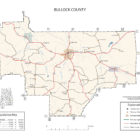
Bullock County Alabama
Bullock County Alabama
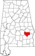
Bullock County Alabama has a population of 10,914. In 1867, Union Springs was chosen as the county seat. Its name is in honor of Colonel Edward C. Bullock of Barbour County.
Bullock County Historical Destinations
Red Door Theatre*
Union Springs
Bird Dog Statue
Union Springs
Bullock County Historic Murals
Union Springs
Bullock County Alabama Cities:
Union Springs, Alabama
The area that became Union Springs was first settled by white men after the Creek Indian removal of the 1830s. Twenty-seven springs watered the land, giving rise to the name of Union Springs. The city was incorporated on January 13, 1844. When Bullock County was formed in 1866, voters selected Union Springs as the county seat.
Union Springs is located in southeastern Alabama near the center of Bullock County. The city is located at the intersection of U.S. Route 82 and U.S. Route 29. Route 82 leads east 40 miles to Eufaula and northwest 46 miles to Montgomery, the state capital. Route 29 leads north 23 miles to Tuskegee and southwest 40 miles to Troy. The source of the Conecuh River is within the city limits.
Bullock County Alabama Towns:
Midway, Alabama
The earliest settler in Midway, originally located in Barbour County, was likely Samuel Feagin, who became a land broker and the first postmaster. Feagin’s son, James Madison Feagin organized the Midway Guards during the Second Creek War (1836-37) when many homes in the area were burned and settlers were driven off their land by the Creeks. The outfit would become the Midway Southern Guards and join the Fifteenth Alabama Infantry Regiment, which fought in many important Civil War battles in Pennsylvania, Tennessee, and Virginia. By 1838, the first post office had been established, and the area apparently was already called Midway. The Battle of Pea River, a conflict during the Second Creek War (1836-37), took place in the area in 1837.
Bullock County Alabama Communities:
Aberfoil Alabama
Aberfoil is an unincorporated community in Bullock County. The main roads through the community are U.S. Route 29 and Alabama State Route 239. A post office was established at Aberfoil in 1837, and remained in operation until it was discontinued in 1905.
Blues Old Stand, Alabama
Blues Old Stand is an unincorporated community in Bullock County. The main road through the community is U.S. Route 29 in Alabama, but also includes Bullock County Roads 14 and 19. According to one account, Blues Old Stand was named for a man named Blue who kept a store known locally as the ‘stand’.
Fitzpatrick, Alabama
Fitzpatrick is an unincorporated community and census-designated place in Bullock County. As of the 2010 census, its population was 83. The community is served by Alabama State Route 110.
Ox Level Alabama
A populated place in Bullock County.
Perote, Alabama
Perote is an unincorporated community in Bullock County. This community, settled during the mid-1830s, was first called Fulford’s Cross Roads, then Missouri Cross Roads when a post office was established here in 1846. The name Perote, adopted in 1850, was suggested by veterans returning from the Mexican War (1846–48), who remembered a citadel in Mexico by that name. Incorporation followed in 1858.
Perote grew rapidly in the 1850s so that by 1860 the community was thriving with several doctors, stores, a carriage factory, a Masonic lodge, and a school. At the beginning of the American Civil War (1861–65), the school numbered about 150 students. Many of the young men from the school served in the Perote Guards, organized in 1859 as war clouds gathered. They went off to war as part of the 1st Alabama Infantry Regiment with uniforms and a flag handmade by the women they left behind.
The community’s fortunes fell following the war as cotton cultivation, the area’s traditional leading economic pursuit, receded in importance. By-passed by the railroad and experiencing several disastrous fires, Perote suffered a steady decline in business activity and population.
Source: Wikipedia contributors, “Perote, Alabama,” Wikipedia, The Free Encyclopedia
Smut Eye Alabama
Smuteye or Smut Eye is an unincorporated community in Bullock County, located northeast of Perote.
Smuteye Pond and Smuteye Lake are located north of Smuteye and south of Aberfoil.
Thompson Alabama
Bullock County Alabama Ghost Towns:
Suspension Alabama
The settlement began as an ancient Muscogee village called “Chananagi”.
The name “Suspension” derives from the temporary suspension of railroad construction at the settlement. The Mobile and Girard Railroad incorporated in 1849 and began laying a track southwest from Phenix City, Alabama. By 1852–53, the grading of the railroad bed had been completed to Union Springs, located 9 miles southwest of the settlement, however, by 1858 the laying of track had only been completed to a location known as “Stewarts Mill” because extensive excavations were required to complete the track from Stewarts Mill to Union Springs. Because the track laying was temporarily suspended at Stewarts Mill, the location became known as “Suspension”. The track was finally completed to Union Springs in 1859–60.
Bullock County Road 40 crosses the now-abandoned railway at Suspension, though nothing remains of the settlement.
See also: Bullock County History by Smith & DeLand 1888 and Bullock County History by Benjamin Franklin Riley
Bullock County Alabama Ghost Towns
Enon
Dates From: 1842
Guerryton
Dates From: 1872
N32 13.257′, W85 30.075′
At the junction of County Road 102 and Countyr Road 103
High Ridge
High Ridge is an unincorporated community in Bullock County. The community was most likely named for the surrounding geography.
A post office operated under the name High Ridge from 1892 to 190
Dates From: 1892
N32 03.766′, W85 53.702′
On the junction of County Road 7 and County Road 14
Peachburg
Dates From: 1876
N32 09.829′, W85 37.443′
Pine Grove
N32 01.641′, W85 36.635′
Postoak
N32 00.060′, W85 49.191′
On the junction of County Road 11 and County Road 8
Simsville
Suspension
Thompson
N32 11.104′, W85 49.089′
Bullock County Alabama Weblinks
Abundant with whitetail deer, hogs, turkey, quail, fish, and all that Bullock County has to offer, this wondrous place is the only place to be when you plan your next hunting or fishing adventure.