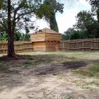
Neamathla, who has been one of the most distinguished of the Seminoles, and was at one time their head man, or principal chief, was by birth a Creek.

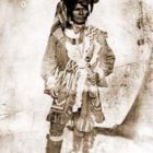
Battle Of Hobdy’s Bridge: Last Significant Indian Battle In Alabama

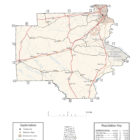
BATTLE OF HOBDY’S BRIDGE
 
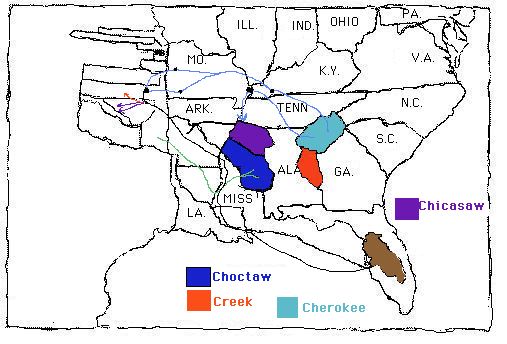
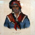
On March 24th, 1837, the last significant Indian battle in Alabama was fought between 900 warriors of the Creek Nation and white settlers. Led by General William Wellborn, a large force of volunteers and militia left Eufaula, Alabama (then called Irwinton) to find and capture or kill the Creek Indians who had fled into the swamps following an attack on the camp where they were being held prior to their removal to present-day Oklahoma. Reaching Hobdy’s Bridge, then a long wooden span and causeway, Wellborn learned that the main party of Creeks were  camped about one mile north of the bridge. Sending part of his force up the east or Barbour County side of the Pea River under Captain Harrell, he moved up the west or Pike County side with his primary command. As he neared the site of the camp, gunfire erupted in the swamp. Wellborn defeated the refugee Creeks but had failed to surround and capture them. They fled south  down the Pea River to its confluence with the  Choctawhatchee and continued across the line into Florida. Several hundred men, women and children fled into the Pea River swamps and began and desperate attempt to make their way to Florida. Outraged over the attacks, they were determined to fight their way through if that’s what it took.

Russell County Alabama

Russell County Alabama


Russell County Alabama, located in the southeastern part of the state,  is a county of Alabama. Russell County, known as “The County of Forts,” because of the many forts that once existed within the county’s boundaries, including Fort Mitchell, Sand Fort, Fort Bainbridge, and a small portion of present-day Fort Benning (most of which is in Georgia).  was established by an act of the state general assembly on December 18, 1832, from lands ceded to the state by the Creek Indians, however, the final geographical boundaries did not exist until 1932. Russell County Alabama History:
Early settlement of Russell County as well as other parts of Alabama followed the establishment of Fort Mitchell. The fort was constructed by Georgia militia in 1813 during the Creek Indian War of 1813-14 to provide military protection for non-Indian expansion into Native American lands. As of the 2010 census, the population was 52,947.

William Weatherford

William Weatherford
William Weatherford, known as Red Eagle (ca. 1781–March 24, 1824), was a Creek chief of the Upper Creek towns who led many of the Red Sticks actions in the Creek War (1813–1814) against Lower Creek towns and against allied forces of the United States. One of many mixed-race descendants of Southeast Indians who intermarried with European traders and later colonial settlers, William Weatherford was of mixed Creek, French, and Scots ancestry. He was raised as a Creek in the matrilineal nation and achieved his power in it, through his mother’s prominent Wind Clan (as well as his father’s trading connections. After he showed his skill as a warrior, he was given the “war name” of Hopnicafutsahia, or “Truth Teller.”

Shelby County Alabama Map

SHELBY COUNTY ALABAMA

Shelby County Alabama

Shelby County Alabama is located near the geographic center of the state of Alabama. The county seat of Shelby County is Columbiana Alabama. The county is named in honor of Isaac Shelby, Governor of Kentucky from 1792 to 1796 and again from 1812 to 1816. Shelby County Alabama History:
The original county boundaries encompassed lands acquired from the Creek Indians in the 1814 Treaty of Fort Jackson following their defeat at the Battle of Horseshoe Bend. The first towns in the Cahaba Valley were Wilson’s Hill (now Montevallo) and Shelbyville (now Pelham).

Reconstructed Stockade of Fort Mitchell

Fort Mitchell: Fort Mitchell, Alabama | Russell County Alabama

The site of Fort Mitchell is now a park in
Russell County, Alabama. The outstanding
historic site features a reconstruction of the
1813 fort, historic burial grounds, a museum
housing a fascinating collection of historic
carriages, a restored 19th century log home
and an impressive visitor center that offers
exhibits, a film and a walk through the history
of the site.

Historic Downtown Opelika

Opelika Alabama

Downtown Opelika features Historic Railroad Avenue, where you can hear the whistles blow and enjoy the rumblings of trains as they travel through the city. The beautiful courtyard and fountain in Lee County Courthouse Square is the site of a variety of special events. History abounds at The Museum of East Alabama.

Creek-Indian-Tribe-of-Alabama

CREEK INDIAN TRIBE OF ALABAMA

ALABAMA CREEK INDIAN TRIBES
NATIVE AMERICAN TRIBES OF ALABAMA INDEX
Muscogee Creek Nation Alabama
Also called the Muscogee, the Creek were made up of several separate tribes that occupied Georgia and Alabama in the American Colonial Period. One of the Five Civilized Tribes, they formed the Creek Confederacy with other Muscogean speaking tribes, the Alabama, Hitchiti, and Coushatta. Their confederacy, which formed the largest division of the Muscogean family, included other Muscogean tribes such as the Catawba, Iroquois, and Shawnee, as well as the Cherokee. Their confederacy, which formed the largest division of the Muscogean family, included other Muscogean tribes such as the Catawba, Iroquois, and Shawnee, as well as the Cherokee. The Creeks were the largest, most important Indian group living in Alabama.

Monroe County Alabama Map

MONROE COUNTY ALABAMA

Monroe County Alabama


Monroe County Alabama, located in the southwest part of the state, has a population of 23, 068. The county seat is Monroeville Alabama. For thousands of years the area was inhabited by indigenous peoples. In historic times, it was primarily the territory of the Creek peoples, who became known to European-American settlers as one of the Five Civilized Tribes of the Southeast.  

 
Monroe County Alabama Cities:
Monroeville, Alabama
Monroeville is the county seat of Monroe County. The town was initially known as Walker’s Mill and Store, named for Major Walker, the area’s first white settler. In 1832, the county seat was relocated to Monroeville from Claiborne on the Alabama River.

Montevallo-Alabama

Montevallo Alabama

The area where Montevallo is now was once controlled by the Creek Indians. After being acquired in 1814 Jesse Wilson claimed a small hill on the northern bank of the Shoal Creek and created a homestead there, making it the oldest settlement in Shelby County. Wilson’s friends and family followed afterwards and also settled in the area, and a settlement known as Wilson’s Hill developed on the site. The settlement’s location at almost the exact center of Alabama meant it was considered one of the potential sites for the University of Alabama. In an attempt to encourage the university to choose the site the settlement changed its name to Montevallo, which is Italian for the hill in the valley.

Muscle-Shoals-Alabama

Muscle Shoals Alabama

Muscle Shoals is the largest city in Colbert County, Alabama. As of the 2010 census, the population of Muscle Shoals was 13,146. The estimated population in 2015 was 13,706