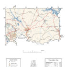
Elmore County Alabama
Elmore County Alabama
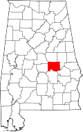
Elmore County is a county of the State of Alabama located in east-central Alabama. Home to some of the most navigable and recreational waterways in the state, it is also the scene of some of the most historic events in the Southeast.
As of the 2010 census, the population was 79,303. Its county seat is Wetumpka. Its name is in honor of General John A. Elmore.
Elmore County was created by the Alabama legislature on 1866 Feb. 15, from parts of Autauga, Coosa, Montgomery, and Tallapoosa Counties.
Elmore county is located in what once was the heart of Upper Creek territory. The present-day towns of Wetumpka and Tallassee, located on the banks of the Coosa and Tallapoosa Rivers, retain the names of the former Creek towns on those sites. Tuckabatchee, one of the principal towns of the Creek Nation, was also located in Elmore County, near the town of Tallassee.
After the arrival of the French in Mobile in 1702, Jean-Baptiste Le Moyne, Sieur de Bienville, sent an expedition up the Alabama River to what is now southern Elmore County to establish Fort Toulouse, completed in 1717. Gen. Andrew Jackson then erected Fort Jackson in 1814 at the site of Fort Toulouse following the Battle of Horseshoe Bend.
The Wetumpka Crater, estimated to be 83 million years old and located on the east side of the city of Wetumpka, is one of the most unique geological features in the state and the only identifited meteor crater in Alabama. It is almost five miles wide.
The Julia Tutwiler Prison for Women of the Alabama Department of Corrections is in Wetumpka in Elmore County. The prison houses Alabama’s female death row. Wetumpka was previously the site of the Wetumpka State Penitentiary.
Elmore County History – in Alabama As It Is – by Benjamin F Riley – 1887
Source: Alabama As It Is by Benjamin Franklin Riley, D. D., 1887
Elmore county was formed in 1866, and named for Gen. John A. Elmore. The historic Tallapoosa, flowing down from the north, makes a great bend and thus forms two sides of the county. Its resources are varied, and its facilities for manufacturing are unsurpassed, if, indeed, they are not unequaled by any other county in Alabama. It embraces 630 square miles.
Population in 1870, 14,477; population in 1880, 17,502. White, 8,747; colored, 8,755.
Tilled Land—73,897 acres. Are planted in cotton, 31,045 acres; in corn, 20,000 acres; in oats, 5,153 acres; in wheat, 3,883 acres; in rye, 27 acres; in rice, 5 acres; in tobacco, 12 acres; in sugar-cane, 16 acres; in sweet potatoes, 642 acres. Cotton Production—9,771 bales.
The surface of this county is generally rolling. The lands vary in appearance and in the merit of their soils. The gray lands have the predominancy in the county, and vary with the different localities. On the Coosa River, above Wetumpka, there are found narrow basins of good land, but out from these bottoms there are formed level plains which are generally covered with a sandy soil. On the side of the Coosa River, opposite the town of Wetumpka, there is an extended level plain which stretches away to the boundary of Autauga county. The character of the land belonging to this level stretch of country is a sandy surface with a stiff clay subsoil. This gives to the wagon-ways a perpetual firmness and renders hauling easy. Following along the Tallapoosa one finds a girt of superior lands which are excellent for the production of cotton and corn. Perhaps the best lands are found in the fork of the Coosa and Tallapoosa Rivers. These alluvial bottoms have been steadily planted for many years, and have yielded unceasingly heavy crops of cotton. The planters prize these river lands because of their capacity to produce the snowy staple more than any others in the county.
The lands that lie above those just alluded to, and which are above the point of the annual overflow of the rivers, are also superb cotton lands, and are regarded the safest lor the production of that staple. Of course, it must not be understood that the production of cotton is confined to these lands. In different parts of the county are brown loam and slaty soils, which yield splendid crops. The productions of the county which may be mentioned as staple are cotton, corn, wheat, oats, rice peas, millet and sugar-cane.
Elmore has many magnificent pine forests. In consequence of of these, a fine lumber and timber business long ago sprang up. Along its numerous streams of extensive water-power are found many large and flourishing mills. These vast domains of pine cover the great level tract of country stretching westward from Wetumpka to the utmost western boundary of the county. Very little shrubbery is here found, but there is a great variety of flowers, and many of them are found in plots or patches of great beauty.
Fruits, domestic and wild, grow with great readiness in Elmore, and in most sections do remarkably well. They always thrive when planted upon sand-covered land, as beneath there is almost the universal prevalence of a clay subsoil. Pears, apples, figs, grapes, peaches, raspberries, strawberries, and others do quite well. The prevailing timbers are oak, pine, hickory, beech, walnut, magnolia, dogwood, gum, and persimmon. Yellow ochre is the only mineral thus far discovered.
At Tallassee, on the Tallapoosa River, is the Tallassee Cotton Factory, which was, for many years, the largest mill of that character in the South. The falls in the river at this point, furnish immense water-power, which is only slightly utilized. This is but one of the numerous sites favorable to the location of manufactories in the county. Splendid streams of water ramify the county in all directions. Among these are the Coosa and Tallapoosa Rivers, Shoal, Wewoka, Mill, Safkahatchee, Hatchee Chubbee, Corn, and Wallahatchee Creeks. These lesser streams find outlets through either the Coosa or Tallapoosa Rivers.
The points of interest in the county are, Wetumpka, the county-seat, with a population of 1,000 ; and Tallassee, with about 1,600; and Robinson Springs. Wetumpka has long been noted as the location of the State penitentiary. Tallassee is famous as a manufacturing center, and Robinson Springs, in former years, was a noted local resort for the elite of Montgomery. It is extremely healthful, and the brace of its clime and its refreshing waters of freestone made it a place of great attraction.
The educational advantages of the county are good, as are also facilities for the enjoyment of religious worship. The means of transportation are convenient. The Louisville and Nashville Railroad runs through the county, a branch of which terminates in Wetumka, while in the eastern end the Western Railroad is sufficiently near to be quite accessible. The Coosa River furnishes another cheap means of transportation to Montgomery and Selma upon the Alabama River, and the cities upon the Southern coast.
Lands may be had from $1.50 to $15 per acre in the county. The government owns 5,000 acres of land subject to entry.
Elmore County History – in Northern Alabama – by Smith and DeLand – 1888
Source: Northern Alabama – Historical and Biographical by Smith & De Land, Birmingham, Ala 1888
ELMORE COUNTY.
Population: White, 8,747; colored, 8,755.
Area, 630 square miles. Woodland, all. Gravelly hills, with long-leaf pine, 230 square miles; metamorphic 400 square miles.
Acres – In cotton (approximately) 31,045; in corn 20,000; in oats 5,153; in wheat 3,883; in rye 27; in rice 5: in tobacco 12: in sugar-cane 16; in sweet potatoes 642. Approximate number of bales of cotton – 10,000.
County Seat – Wetumpka; population 1,200: on the Wetumpka branch South & North Railroad.
Newspapers published at County Seat – Elmore Express, Times (both Democratic).
Post offices in the County – Bingham, Buyck, Central Institute, Channahatchee, Colley, Coosada Station, Cotton’s Store, Deetsville, Eclectic, Edgewood, Elmore, Good Hope, Irma, Kowaliga, Robinson Springs, Sand Tuck, Sykes’ Mills, Tallassee, Ware, Weoka, Wetumpka.
Elmore County was created out of portions of Coosa, Autauga, Montgomery and Tallapoosa Counties, by an act of the Legislature approved February 15, 1866. The county was named for Gen. John A. Elmore, who was one of the first settlers of Autauga County, and resided in that portion which was embraced in this county. The county is divided into two parts by the Coosa River, and the Tallapoosa, which forms a portion of its eastern boundary, takes a bend and washes its entire southern border.
The surface of the county is generally rolling. The lands vary in appearance, and in the merit of their soils. The gray lands have the predominancy in the county, and vary with the localities. On the Coosa River above Wetumpka, there are found narrow basins of good land, but out from these bottoms there are formed level plains which are generally covered with a sandy soil. On the side of the Coosa River, opposite the town of Wetumpka, there is an extended plain which stretches away to the boundary of Autauga County. The character of the land belonging to this level stretch of country is a sandy surface with a stiff clay subsoil. This gives to the wagon ways a perpetual firmness, and renders hauling easy. Following along the Tallapoosa one finds a girt of superior lands which are excellent for the production of cotton and corn. Perhaps the best lands are found in the fork of the Coosa and Tallapoosa Rivers. These alluvial bottoms have been steadily planted for many years, and have yielded unceasingly heavy crops of corn and cotton. The planters prize these river lands because of their capacity to produce the snowy staple as well as the staff of life, to-wit, corn, more than any others in the county.
The lands that lie just above those alluded to, and which are above the annual overflow of the rivers, are also superb cotton lands, and are regarded the safest for the production of that staple. Of course, it must not be understood that the production of cotton is confined to these lands. In different parts of the county are brown loam and slaty soils, which yield splendid crops.
Elmore has many magnificent pine forests, and on many of its streams fine saw-mills are erected, which turn out large quantities of fine pine lumber for local use, as well as for shipment to southern and western markets.The health of the county is unsurpassed, and all portions of it possess drinking water as pure and wholesome as any found in any portion of the world. The climate is equable, and the hills make most desirable residences for those to whom a healthy locality and an abundance of pure water for all purposes is an inducement in selecting a home.
Among the fruits which experience has proven will thrive in Elmore County may be mentioned: pears, apples, figs, peaches and grapes, while strawberries, raspberries and other small fruits yield abundantly.
The timber of the county consists of oak, pine, hickory, beech, walnut, magnolia, dogwood, gum and persimmon.
Yellow uchre has been discovered at several points in the county, and is reported to be of an excellent grade. The county can produce a buhr stone, for millstones, which in service is equal to any ever used, and in crushing corn into meal is superior to many so-called finer varieties. In addition there are deposits of stone which is very durable and useful as a building stone. Gold exists in localities in the county, and has been worked with great profit and satisfaction to those engaged. Large deposits of clay have been found in the county, which is thought valuable for the manufacture of a tine grade of porcelain ware, while some sands of the county have been pronounced to be excellent for making glass.
At Tallassee, on the Tallapoosa River, is the Tallassee Cotton Factory, which was, for many years, the largest mill of that character in the South. The falls in the river at that point furnish immense water-power, which is only slightly utilized. This is but one of the numerous sites favorable to the location of manufactories in the county.
Splendid streams of water ramify the county in all directions. Among these are the Coosa and Tallapoosa Rivers, Shoal, Wewoka, Mill, Safkahatchee, Hatchee, Chubbee, Corn, and Wallahatchee Creeks. These lesser streams find outlets through either the Coosa or Tallapoosa Rivers.
The points of interest in the county are Wetumpka, the county seat, with a population of 1,500; Tallassee, with about 1,200; and Robinson Springs. Wetumpka has long been noted as the location of the State Penitentiary. Tallassee is famous as a manufacturing center, and Robinson Springs, in former years, was a noted local resort for the elite of Montgomery.
The educational advantages of the county are good, as are also facilities for the enjoyment of religious worship. The means of transportation are convenient. The Louisville & Nashville Railroad runs through the county, a branch of which terminates at Wetumpka, while in the eastern end the Western Railroad is sufficiently near to be quite accessible. The Coosa River furnishes another cheap means of transportation to Montgomery and Selma upon the Alabama River, and the cities upon the Southern coast.
Lands may be had from $1.50 to $15 per acre in the county. The Government owns 7,320 acres of land subject to entry.
Elmore County Alabama Cities
Prattville Alabama
Prattville has that wonderful “hometown” feeling. It is a place where you feel that you belong, a safe place where you can raise a family, or spend your retirement years
Millbrook Alabama
With a rich heritage dating back to the 1700’s. A rapidly growing Interstate 65 city, Millbrook, Alabama is located 10 miles north of Montgomery, Alabama’s state capital. Immediately accessed via Interstate 65 Exits 176, 179 and 181, Millbrook’s proximity and inclusion in the Montgomery MSA (population 374,536), help shape the city and provide for exceptional career, educational, cultural and recreational opportunities. Regularly ranked among Alabama’s fastest growing cities, Millbrook’s present day estimated population is 14,734.
Tallassee Alabama
Tallassee has maintained her small town charm in a family-oriented atmosphere. City officials and employees work hard to create and maintain a community that is attractive to our visitors and those who choose Tallassee as their home.
Wetumpka Alabama
Wetumpka identifies as “The City of Natural Beauty”. Among the notable landmarks are the Wetumpka crater and the Jasmine Hill Gardens, with a full-sized replica of the Temple of Hera of Olympia, Greece. Historic downtown Wetumpka developed on both sides of the Coosa River. It was located near Fort Toulouse, built by French colonists in 1717, when they had claimed this territory for the king.
Elmore County Alabama Towns
Coosada Alabama
Coosada is a town in Elmore County. At the 2010 census the population was 1,224. It is part of the Montgomery Metropolitan Statistical Area.
Deatsville Alabama
Deatsville is a town in Elmore County. Although Deatsville initially incorporated in 1903, it lapsed at some point after the 1910 U.S. Census and did not appear again as incorporated until 2000. As of the 2010 census, the population was 1,154, up from 340 in 2000.
Eclectic Alabama
Eclectic is a town in Elmore County. It incorporated in 1907. At the 2010 census the population was 1,001. It is part of the Montgomery Metropolitan Statistical Area. Eclectic was founded by Dr. M. L. Fielder, a practitioner of eclectic medicine, hence the name. It has frequently been noted on lists of unusual place names. The first post office in Eclectic was established in 1879.
Town of Eclectic
145 Main St Eclectic AL 36024 US
Telephone: +1.3345414429
FAX: 334-541-2854
Elmore Alabama
Within the calm settings of the beautiful River Region, there is a place where memories are made. A place where freedom and adventure still capture the hearts of people. Discover a place in America’s south you may just want to call home. That place is right here, the Town of Elmore, Alabama!
Elmore Town Hall
485 Jackson Street
Elmore, AL 36025
Phone: (334) 514-5988
Fax: (334) 514–5778
Elmore County Alabama Census-designated Places
Blue Ridge Alabama
Blue Ridge is an unincorporated community and census-designated place in Elmore County. At the 2010 census the population was 1,341. It is part of the Montgomery Metropolitan Statistical Area.
Emerald Mountain Alabama
Emerald Mountain is a census-designated place in Elmore County. Its population was 2,561 as of the 2010 census. It is a planned community with an Architectural Review Board and a Homeowners Association of which membership is mandatory. Community facilities include a tennis center, equestrian center and golf club.
Holtville Alabama
Holtville is a census-designated place and unincorporated community in Elmore County. Its population was 4,096 as of the 2010 census. Holtville/Slapout is located on the western bank of Lake Jordan, and much of its population lives along this lakeshore, or in the neighboring Lightwood community. According to tradition, the old name of Slapout was derived from a storekeeper’s way of stating an item was out of stock: he was “slap out of it”.
Redland Alabama
Redland is a census-designated place in Elmore County. Its population was 3,736 as of the 2010 census.
Elmore County Alabama Unincorporated Communities
Burlington Alabama
Burlington, also known as Mount Olive, is an unincorporated community located in Elmore County.
Equality Alabama
Equality is an unincorporated community in Coosa, Elmore and Tallapoosa counties.
Kent Alabama
Kent is an unincorporated community in Elmore County, located on Alabama State Route 229, 6.6 miles north-northwest of Tallassee. Kent had a post office from November 29, 1913, until August 20, 1988; it still has its own ZIP code, 36045.
Seman Alabama
Seman is an unincorporated community located in Elmore County, located along Alabama State Route 9, 9.6 miles north-northwest of Eclectic.. Seman is most likely named for the Seman family, who were early settlers of the area. A post office operated under the name Seman from 1902 to 1968.
Titus Alabama
Titus is an unincorporated community in Elmore County. Titus is 13.2 miles north-northwest of Wetumpka. Titus has a post office with ZIP code 36080.
Titus is located at 32.712222, -86.318333
Elmore County Alabama Ghost Towns
Fort Toulouse Alabama
Latitude N32 30.031′ Longitude W86 15.000′
32°30’01.9″N 86°15’00.0″W
32.500517, -86.250000
Good Hope Alabama
Latitude N32 32.315′ Longitude W85 58.459′
32°32’18.9″N 85°58’27.5″W
32.538583, -85.974317
Lightwood Alabama
Latitude N32 42.716′ Longitude W86 23.350′
32°42’43.0″N 86°23’21.0″W
32.711933, -86.389167
Elmore County Alabama Historic Destinations
Benjamin Fitzpatrick Bridge – Tallassee
Fort Toulouse-Fort Jackson Park – Wetumpka
Elmore County Museum – Wetumpka
Jasmine Hill Gardens – Wetumpka
Museum of Black History – Wetumpka
Elmore County Alabama Weblinks
The ANC is a Planned-Use Outdoor Education Facility offering hands-on, outdoor-based educational programs and activities for students, educators, church and civic groups, and the general public.
he NaturePlex is the 23,000 square foot structural facility that serves as the Welcome and Education Center for the Alabama Nature Center. The facility includes a 120-seat Theater equipped with up to date technology; Hands-on Discovery Hall with wildlife and nature-based displays; Educational Classrooms; Community Room available for meeting use and rental; and a Gift Shop.
The NaturePlex can be reserved for school field trips, teacher training workshops, seminars, and other educational programs by contacting the Alabama Wildlife Federation.
3050 Lanark Rd
Millbrook, Alabama 36054
(800) 822-9453
Elmore County was established on February 15, 1866, from portions of Autauga, Coosa, Tallapoosa, and Montgomery counties. The French established Fort Toulouse at the confluence of the Coosa and Tallapoosa in 1717. Gen. Andrew Jackson then erected Fort Jackson in 1814 at the site of Fort Toulouse following the Battle of Horseshoe Bend.City of Wetumpka
Administrative Building
408 S Main St.
P. O. Box 1180
Wetumpka, AL 36092-2748
Phone: (334) 567-5147
Fax: (334) 567-1307
Mayor: mayor@cityofwetumpka.com
City Clerk: trobinson@cityofwetumpka.com
Finance Director: jcreel@cityofwetumpka.com
Office Hours:
Monday - Friday
8 A.M. - 4:30 P.M.
(334) 567-3002
Elmore County was established on February 15, 1866, from portions of Autauga, Coosa, Tallapoosa, and Montgomery counties. The French established Fort Toulouse at the confluence of the Coosa and Tallapoosa in 1717. Gen. Andrew Jackson then erected Fort Jackson in 1814 at the site of Fort Toulouse following the Battle of Horseshoe Bend.Cypress Lane
Millbrook, Alabama 36054
(334) 430-7963
3001 Jasmine Hill Rd
Wetumpka, Alabama 36093
(334) 567-6463
Weaving together collection, preservation, presentation and education through programs, exhibitions and partnerships that engage, inspire and advance the visual arts.
Elmore County was established on February 15, 1866, from portions of Autauga, Coosa, Tallapoosa, and Montgomery counties. The French established Fort Toulouse at the confluence of the Coosa and Tallapoosa in 1717. Gen. Andrew Jackson then erected Fort Jackson in 1814 at the site of Fort Toulouse following the Battle of Horseshoe Bend.With a rich heritage dating back to the 1700’s, the Millbrook area, including Robinson Springs, Coosada, Deatsville, and Elmore, was known for its sprawling plantations and prominent leaders, including William Wyatt Bibb, John Archer Elmore, and Benjamin Fitzpatrick. Today, the area retains the best of its early features and natural resources, while aggressively pursuing economic development opportunities.
Elmore County was established on February 15, 1866, from portions of Autauga, Coosa, Tallapoosa, and Montgomery counties. The French established Fort Toulouse at the confluence of the Coosa and Tallapoosa in 1717. Gen. Andrew Jackson then erected Fort Jackson in 1814 at the site of Fort Toulouse following the Battle of Horseshoe Bend.