ETOWAH COUNTY ALABAMA
Etowah County Alabama

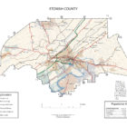
Etowah County is a county of the U.S. state of Alabama. Etowah county is located in the northeastern section of the state, in the southern Appalachians. As of the 2010 census the population was 104,430. Its county seat is Gadsden. It is the smallest county in Alabama but one of the most densely populated. Its name is from a Cherokee word meaning “edible tree”.
Etowah County Alabama History
The Alabama legislature established Etowah County on December 7, 1866. The territory of Etowah County was originally split among the neighboring counties, with most of it belonging to DeKalb and Cherokee counties.In honor of the confederate soldier, General David W. Baine, Etowah County was originally named Baine County. Baine County officially became known as Etowah County on December 1, 1868. The county was abolished on 1868 Dec. 1 by the Constitutional Convention and re-established on the same day, under the name of Etowah, which is from the Cherokee language.
The first settlement in what is now Etowah County was located at a town called Double Springs on the Coosa River.
Source: Alabama As It Is by Benjamin Franklin Riley, D. D., 1887
The county of Etowah derives its name from an Indian term which means pine tree. It was created in 1866 under the name of Baine, which name it retained for two years, when it was changed to Etowah. It is located in that section of the State which abounds in numerous elements of natural wealth, such as productive lands, forests of valuable timber, and deposits of ore. Pluck and capital are needed to develop the immense resources in which Etowah abounds. Favored both with railroad and river transportation, the county ought to be speedily developed. But let us examine more minutely into its merits.
Its area is 520 square miles.
Population in 1870, 10,109; population in 1880, 15,398. Whites, 12,896; colored, 2,502.
Tilled Land: 60,780acres.—Area planted in cotton, 15,187 acres; in corn, 24,891 acres ; in oats, 5,025 acres ; in wheat, 7,063 acres; in tobacco, 47 acres; in sugar cane, 9 acres ; in sweet potatoes, 230 acres.
Cotton Production: 6,571 bales.
The county of Etowah is penetrated from the northeast to the southwest by two mountain plateaus and three valleys. The Coosa river flows through the eastern part of the county, thereby forming the valley of the same name, the fertility of which we have had occasion already to notice. The historic Coosa sweeps directly along the heart of the valley, which curves with the natural windings of the river. The valley begins to form by a slight undulation about three or four miles on either side of the Coosa.
As in other counties penetrated by this noted Coosa Valley, it is broken here and there by dividing ridges.
Beginning southwest of Gadsden and extending to the utmost limits of the county are what are locally known as ” The Flatwoods.” This is quite a level tract of country. With the proper drainage this broad domain could be brought into agricultural requisition, but as it is but poorly drained it is comparatively little cultivated. Nothing seems wanting but drainage, as the natural growth and analysis of the soils show that the land is capable of at least moderate production.
Flanking the flat woods region are the cultivated lands of the belt. The land here is of a brownish cast and produces well. The Look-out Mountain plateau extends from the northeastern part of the county to Gadsden. This table-land is covered with the rocks of the Coal Measures, the soils of which, as usual, are sandy, alternating with loam.
Wills’ Valley lies between this plateau and another from Sand Mountain, which runs parallel with the former.
Beyond this still is Murphree’s Valley. These valley lands are quite productive, being of a dark mulatto or mahogany color. These lands are usually stiff, but yield abundant results where properly drained, deeply plowed, and otherwise well cultivated. The lands lying along the ridges and plateaus are sandy and easily cultivated. Upon these plateau lands there can be a more rapid rotation of crops, as they grow up rapidly and mature speedily. In the valleys are forests of oak, hickory, chestnut, and walnut. The Flatwoods region is covered with post, red, Spanish, and black-jack oaks, together with sweet and sour gums, and short-leaf pines. The chief products of the county are cotton, corn, wheat, oats, millet, sorghum, sweet and Irish potatoes, and clover. The plateaus yield very fine fruits, especially apples, pears, peaches, and plums. So well adapted are the soils to the production of the clovers and grasses that attention is being directed to stock-breeding. For many years the production of wool has been a specialty in the county. A few years ago it ranked third in the production of wool. The county is watered by Big and Little Wills’ creeks, Black creek, and the Coosa river. There are many bold springs in different parts of the county. Transportation is furnished by the Alabama Great Southern railroad, which connects with the steamers on the Coosa at Gadsden, by means of a short line running between the last-named place and Attalla. This affords an easy outlet by rail from Gadsden to New Orleans, Cincinnati, Atlanta, Chattanooga, Birmingham, and other points of importance. Considerable quantities of iron ore are mined in the neighborhood of Attalla and shipped to the furnaces at Birmingham and Chattanooga. In this particular section are many excellent lumber mills.
Gadsden, with a population of 1,800, is a thrifty mountain town, favorably located upon the Coosa river, which affords it easy communication with Rome, Georgia. It is connected with the Queen and Crescent route by a short line running to Attalla. It is regarded one of the best lumber markets in the State, having a number of extensive mills for the manufacture of lumber. Beside these, there is a large sash, door, and blind factory, and a broom-handle factory. In the neighborhood of the town there are several coal mines which are being successfully worked.
The town abounds in excellent church and school advantages.
Its natural scenery can not be surpassed by that of any other point in the State.
The scene is that of a busy little city nestled amid its native groves of oak at the base of high mountains, the woody flanks of which extend even to the limits of the city.
Various manufactories are found here, chief among which are the Coosa charcoal furnaces, which are among the largest and best in the State. Not a great distance from the city is mined brown hematite ore, which is broadly diffused throughout this section. The extent of the prevalence of this ore has not yet been determined, but is evidently considerable.
Sweeping past the city on the east is the Coosa river, upon the bosom of which float steamers of commerce which ply in both directions. In the sections adjacent to the town are many mineral springs, which are points of frequent resort. Black Creek Falls, but a short distance from Gadsden, are an object of great natural wonder.
Attalla is another town of some importance because of its neighboring iron mines.
Lands may be purchased at prices running all the way up from $2.50 to $20. There are in the county 12,121 acres of Government land.
Source: Northern Alabama – Historical and Biographical by Smith & De Land, Birmingham, Ala 1888
Population: White, 19,808; colored, 3,000. Area. 520 square miles. Woodland, all. Coal measures. 140 square miles (40 on Lookout Mountain and 100 on Sand Mountain).
Acres – In cotton, approximately 17,000; in corn 24,891; in oats 6,000; in wheat 7,000; in tobacco 67; in sugar-cane 9; in sweet potatoes 260.
Approximate number of bales of cotton, in round numbers, 7,500.
County Seat – Gadsden: population, 4,000.
Newspaper published at County Seat – Times and News.
Post offices in the county: Atalla, Aurora, Ball Play, Buford, Clear Spring, Coats Bend, Coxville, Duck Springs. Etowahton, Gadsden, Greenwood, Hill, Hokes Bluff, Howelton, Keysburgh, Markton. Nix, Oak Hill, Heaves, Red Bud, Seaborn, Shahan. Stanfield, Turkeytown, Walnut Grove.
Three-fourths of the county is made up of mountain plateaus or table lands.
The agricultural resources of the county are tine, and when you take into consideration the diversity of crops which flourish in it, it is equaled by few counties in the State.
The county contains lands of nearly every variety, and these lands are adapted to raising profitably many of the cereals and fruits. Some of the richest valley lands to be found in the State are in this county, and these valley lands produce the finest staple of cotton, as well as abundant crops of corn, oats and wheat. Some of these valleys are remarkable for their beauty, as well as their fertility, and we mention the Little Wills Valley, up which runs the Great Southern Railroad.
We have these beautiful valleys running through the county, in addition to the Coosa River bottoms, as they are called. This Coosa bottom land is remarkable for producing a very fine grade of cotton, from which the celebrated Coates thread is made. It also yields large crops of corn and oats, and other small grains.
The county is penetrated from the northeast to the southwest by two mountain plateaus and their valleys. As before mentioned, nearly three-fourths of the county is mountainous, the other fourth takes in the three valleys. These valleys are known as the Coosa Valley, which averages from three to four miles on either side of the river, making its width about six or seven miles.
The other two valleys are known as Big and Little Wills Valleys, and are remarkable for their beauty and fertility, especially the latter, which is the smaller of the two valleys. ……..
Etowah County Alabama Civil War Events
On May 2, 1863, during Union colonel Abel Streight’s raid through north Alabama, a local farmer named John Wisdom gained notoriety when he raced ahead of Streight’s troops, who were in turn being pursued by Confederate general Nathan Bedford Forrest, to Rome, Georgia, to warn the town’s citizens of the Union troops’ impending arrival. A young girl named Emma Sansom became a local heroine during the raid when she led Forrest and his men across Black Creek to capture Streight’s troops.
Etowah County Alabama WWII Events
In 1942, the U.S. took possession of 36,300 acres in Etowah and adjoining St. Clair County to establish Alabama’s first Chemical Warfare Center (CWC). Known as Camp Sibert, it served as a Unit Training Center and a Replacement Training Center for the CWC. Deactivated in 1945, Camp Sibert was the training site for more than 45 percent of all CWS troops who served in World War II.
Etowah County Alabama Contact Information
Etowah County Alabama Courthouse
Etowah County Alabama Quick Links
Etowah County Alabama Cities
Attalla, Alabama

Attalla is a city in Etowah County, Alabama. As of the 2010 census, the population was 6,048. The town occupies the site of an Indian village which was of considerable importance during the Creek War. It was in Attalla that David Brown, a Cherokee assisted by the Rev. D. S. Butterick, prepared the Cherokee Spelling Book.
Attalla was not founded until 1870, on land donated by W. C. Hammond, a plantation owner. It was incorporated as a city government on February 5, 1872. The town was officially named “Attalla” in 1893, from the Cherokee language word meaning “mountain”.
Attalla is the site of the first hydroelectric dam to provide electricity for a city, constructed in 1887. In 1903, Gadsden resident William Patrick Lay built his first hydroelectric plant on Big Wills Creek, which furnished the town of Attalla with electricity. He organized Alabama Power Company in 1906.
Attalla, Alabama Website
Attalla Alabama Festival
Heritage Day: Held the third Saturday in October each year. The City of Attalla and our sponsors are proud to present, Attalla Heritage Day. The festival features arts & crafts, car show, bands, food vendors and a large children’s area including free rides, games and activities. Heritage Day is a FREE fun filled family event!
The festival is located in a blocked off area of downtown Attalla which includes antiques, restaurants, boutiques and professional services. 9 a.m.-4 p.m.
Attalla Alabama Police Department
Chief of Police: Dennis Walker
(256) 538-7837
302 6th Ave NW, Attalla, AL 35954
Boaz Alabama
Boaz is located in the northeast part of the state primarily in Marshall County, although part of the city also is located in Etowah County. First settled in the 1850s, the town of Boaz was officially founded November 11, 1878 by the Sparks Family of Georgia. The city was named after Boaz, from the Bible. It was incorporated in 1897.
Boaz Alabama Events
The Boaz Harvest Festival, established in 1965, is held on the first weekend in October. It features the crowning of a Miss Harvest Festival and a Little Miss Harvest Festival, as well as vendors for food and arts and crafts. The city also holds a fireworks display and concert in celebration of the Fourth of July, an antique tractor show in late July, and a Christmas Parade.
Gadsden Alabama
Gadsden is the county seat, named after Col. James Gadsden, distinguished soldier, diplomat, railroad president and famous for the Gadsden Purchase. Gadsden became an important military center during World War II, when the Gadsden Ordnance Plant was constructed to produce shells for cannons. By the end of the war in 1945, the plant had produced more than 16 million shells.
Glencoe Alabama
Glencoe is a city in Calhoun and Etowah counties. The town was named after the town of Glencoe in Scotland. The city incorporated in 1939, had electric power through a contract with Alabama Power Company in 1941, a city-run water system in 1944, and a volunteer fire department by 1946. Home delivery of mail began in 1962.
Glencoe Alabama Events and Places of Interest
Hokes Bluff Alabama
Nestled in the foothills of the Appalachian Mountains, Hokes Bluff, Alabama is a place unlike any other. Scenic hills and beautiful fresh water, make the area a must see for people wanting a beautiful place to call home. Located outside Gadsden, Hokes Bluff provides quick access to major metropolitan areas, including being within 2 hours of Atlanta, GA; and hour from Birmingham and Chattanooga; Hokes Bluff is a hidden treasure of peace in world of chaos.
Hokes Bluff was established on a high bluff overlooking the Coosa River. The town was called “The Bluff”, and was used as a lookout station for Native American tribes, as they could see a great distance across, up and down the Coosa River. Hokes Bluff was one the staging areas where the Cherokee were collected, and sent to Gunter’s Landing (Guntersville), and west to Oklahoma on the Trail of Tears.
Wikipedia has a very interesting page on the history of Hokes Bluff.
Rainbow City Alabama
Settled in the early 1800’s it is now one of the fastest growing areas in the county with many new business, industries, and homes springing up along its major thoroughfares. Rainbow City extends from the city of Gadsden on the north to the county line on the south and east to the Coosa River.
Rainbow City was named after U.S. Highway 411, called Rainbow Drive, which runs through the middle of our city. Some of our older citizens say it was named after Alabama’s Rainbow Division that fought in World War I.
Hernando DeSoto’s troops were the first visitors to the area in 1540 and today a bridge now stands where the Pensacola Trading Path crossed the Coosa River. A paved highway now traces the trail that was cut from Nashville to Horseshoe Bend by Andrew “Old Hickory” Jackson on his way to fight the Creek Indians in a battle known today as the Battle of Horseshoe Bend.
The source of the above information is Rainbow City’s website which has more very interesting information about the city. Visit this link for some interesting history.
Southside Alabama
Southside was first settled in 1850. Southside began as a small rural community with townships such as Green Valley, Cedar Bend, and Pilgrims Rest. The communities banded together to form the town of Southside.
Southside’s dominant source of income was farming. Green Valley was the early center of Southside’s industry. The grist mill, blacksmith, and the sorghum mill were located there. Southside’s cotton gin was located at Brannon Springs and Highway 77.
Southside is sometimes referred to as “Smokeneck.”
The source of the above information is The City of Southside website. A very interesting history of the city is available on the “History” page. It’s very interesting.
Etowah County Alabama Towns:
Altoona Alabama
Altoona is a town in Etowah County and a small portion of Blount County. The town extends west into Blount County. It is located in the Murphree Valley at the base of Altoona Mountain. Straight Mountain is a small, narrow ridge which runs nearly through the center of the town. Altoona had its start in the year 1900 as a mining town, and was named for another coal town, Altoona, Pennsylvania.
Reece City Alabama
Reece City is located in central Etowah County. It is in the valley of Little Wills Creek, bordered by Big Ridge to the west and Lookout Mountain to the east.
Reece City is a town located in central Etowah County in the northeastern corner of the state. It was incorporated in May 1956. It is part of the Gadsden Metropolitan Statistical Area. At the 2010 census the population was 653.
The first non-Indian settlers in the Little Wills Valley, where Reece City is now located, arrived in 1835. The first post office opened in October 1884, and the settlement was called Hill; in 1903, the name was changed to Reeceville after an early settler in the area.
Ridgeville Alabama
Ridgeville is a town in Etowah County. It incorporated in 1969 and is part of the Gadsden Metropolitan Statistical Area. At the 2010 census the population was 112, down from 158 in 2000. It is noteworthy for being the only community in Etowah County to have a black majority.
Sardis City Alabama
Sardis City is a town in Etowah and Marshall counties. It is part of the Gadsden Metropolitan Statistical Area. It originally incorporated in May 1963 under the name of Sardis. It later became Sardis City in the 1980s. At the 2010 census the population was 1,704.
Walnut Grove Alabama
Walnut Grove was settled in the early 1810s and was initially known as Thomas Cross Roads. In February 1848, the town’s name was changed to Cornelius. The town’s name was changed again to Walnut Grove in September 1849. Near the end of the Civil War, the entire settlement was burn by a gang alleged to be Union sympathizers. It was quickly rebuilt.
Etowah County Alabama Communities:
Ballplay Alabama
Ballplay is an unincorporated community and census-designated place in Etowah County. Its population was 1,580 as of the 2010 census.
Ballplay was so named because Native Americans would play stickball at the site in order to resolve disputes between tribes.
A post office was established at Ballplay in 1840, and remained in operation until it was discontinued in 1905.
Bristow Cove Alabama
Bristow Cove is an unincorporated community and census-designated place in Etowah County. Its population was 683 as of the 2010 census.
Carlise-Rockledge Alabama
Coats Bend Alabama
Coats Bend is a census-designated place in Etowah County.
Egypt Alabama
Egypt is a census-designated place and unincorporated community in Etowah County. Its population was 932 as of the 2010 census.
Gallant Alabama
Gallant, also known as Clear Springs or Greasy Cove, is a census-designated place and unincorporated community in Etowah, and St. Clair counties. It lies west of the city of Gadsden, the county seat of Etowah County. As of the 2010 census, its population was 855.
Ivalee Alabama
Ivalee is a census-designated place and unincorporated community in Etowah County. Its population was 879 as of the 2010 census.
Lookout Mountain Alabama
New Union Alabama
New Union is a census-designated place in Etowah County. Its population was 955 as of the 2010 census.
Owassa Alabama
Tidmore Bend Alabama
Tidmore Bend is a census-designated place in Etowah County. Its population was 1,245 as of the 2010 census.
Whitesboro Alabama
Whitesboro is a census-designated place and unincorporated community in Etowah County. Its population was 2,138 as of the 2010 census.
Anderson Alabama
Liberty Hill Alabama
Pilgrims Rest Alabama
Pilgrims Rest is an unincorporated community in Etowah County.
Mountainboro Alabama
Etowah County Alabama Notable Sights and Events
Sand Mountain and Lookout Mountain are located in Etowah County. Etowah County is the starting point for the annual World’s Longest Yard Sale, a multi-state, three-day event that stretches more than 690 miles and culminates in Addison, Michigan.
If you would like to become a sponsor, advertise a related location, service or vacation spot that would add to the usefulness of this site, please email us: staff@digitalalabama.com.
Nestled in the foothills of the Appalachian Mountains, Hokes Bluff, Alabama is a place unlike any other. Scenic hills and beautiful fresh water, make the area a must see for people wanting a beautiful place to call home. Located outside Gadsden, Hokes Bluff provides quick access to major metropolitan areas, including being within 2 hours of Atlanta, GA; and hour from Birmingham and Chattanooga; Hokes Bluff is a hidden treasure of peace in world of chaos.
Etowah County is a county located in the northeastern part of the U.S. state of Alabama. As of the 2010 census the population was 104,430. Its county seat is Gadsden. Its name is from a Cherokee word meaning "edible tree". In total area, it is the smallest county in Alabama, but one of the most densely populated.Settled in the early 1800’s it is now one of the fastest growing areas in the county with many new business, industries, and homes springing up along its major thoroughfares. Rainbow City extends from the city of Gadsden on the north to the county line on the south and east to the Coosa River.
Rainbow City was named after U.S. Highway 411, called Rainbow Drive, which runs through the middle of our city. Some of our older citizens say it was named after Alabama’s Rainbow Division that fought in World War I.
Etowah County is a county located in the northeastern part of the U.S. state of Alabama. As of the 2010 census the population was 104,430. Its county seat is Gadsden. Its name is from a Cherokee word meaning "edible tree". In total area, it is the smallest county in Alabama, but one of the most densely populated.Southside is a relatively small, but progressive area and is always looking for ways to improve the quality of life for its residents.
Etowah County is a county located in the northeastern part of the U.S. state of Alabama. As of the 2010 census the population was 104,430. Its county seat is Gadsden. Its name is from a Cherokee word meaning "edible tree". In total area, it is the smallest county in Alabama, but one of the most densely populated.Etowah County Alabama Historic Destinations
Emma Sansom Monument – Gadsden
Emma Sansom (June 2, 1847 – August 9, 1900) was an Alabama farmgirl noted for her actions during the American Civil War, during which she helped Confederate general Nathan Bedford Forrest cross the Coosa River.
Gilliland-Reese Covered Bridge – Gadsden
Etowah Heritage Museum – Gadsden
Located at Elliott Community Center, the Etowah County Historical Society displays many exhibits, offers a large history library with over 15,000 digitized local historical photos, provides genealogy information, and so much more.
Mont Glosser Amphitheater – Gadsden
Gadsden Museum of Art and History – Gadsden
Noccalula Falls Park – Gadsden
Etowah County Alabama Ghost Towns
Carlisle Alabama
Latitude N34 07.735′ Longitude W86 07.208′
34°07’44.1″N 86°07’12.5″W
34.128917, -86.120133
Markton Alabama
Latitude N33 52.808′ Longitude W86 00.603′
33°52’48.5″N 86°00’36.2″W
33.880133, -86.010050
Rock Springs Junction Alabama
Latitude N33 55.400′ Longitude W85 54.740′
33°55’24.0″N 85°54’44.4″W
33.923333, -85.912333
Rollins Alabama
Latitude N34 10.929′ Longitude W86 05.786′
34°10’55.7″N 86°05’47.2″W
34.182150, -86.096433
Tummin Gap Alabama
Latitude N34 00.690′ Longitude W86 15.406′
34°00’41.4″N 86°15’24.4″W
34.011500, -86.256767
Turkeytown Alabama
Latitude N34 05.595′ Longitude W85 53.894′
34°05’35.7″N 85°53’53.6″W
34.093250, -85.898233