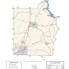
HENRY COUNTY ALABAMA
Henry County Alabama

Located in the southeastern part of the state, Henry County is known as the Cradle of the Wiregrass because nine Alabama counties in the Wiregrass region were formed from lands once encompassed by the county.
Henry County Alabama History
The earliest settlers came to the area from Georgia and the Carolinas via Fort Gaines after the 1814 Treaty at Fort Jackson, in which the Creeks ceded their lands along the Chattahoochee River to the United States.
Henry County Alabama Cities
Abbeville Alabama

Abbeville is the county seat of Henry County. Abbeville is the oldest remaining colonial settlement in East Alabama from Florida to the Tennessee line. It is older than both the county of Henry and the State of Alabama. The city was named for Abbe, a local Muscogee Indian man, at the time of the town’s settlement. The name means “a grove of dogwood trees.”
Dothan Alabama
Located a few short miles from the state lines of Florida and Georgia, the area embraces the best that life has to offer, providing its residents not only modern conveniences and amenities of much larger cities, but also retains the charm and friendliness of the South.
Headland Alabama
Headland, Alabama, the largest city in Henry County, is a growing city located in the southwestern section of Henry County in the southeastern section of the State of Alabama.
As of the 1960 U.S. Census, Headland had grown into Henry County’s largest city, narrowly edging out Abbeville, which had been the largest since Dothan was removed into Houston County in 1903. Headland lost that distinction to Abbeville again in 1970, but regained it in 1980 and has since solidified its hold. In 2000, it broke Dothan’s then-Henry County 1900 record of 3,275 residents with 3,523 and added nearly 1,000 more by 2010.
Henry County Alabama Towns
Haleburg Alabama
Haleburg is located in southeastern Henry County in the southeastern corner of the state just west of the Chattahoochee River. The Haleburg area was first settled during the late 1810s. It was named for Jonathan Hale, an early settler, although some sources give his name as Hales.
Newville Alabama
Newville is located in southwestern Henry County in the southeastern corner of the state. The Newville area was first settled in 1882. When word came that the Alabama Midland Railroad was building a line through the area, two local entrepreneurs, James Wells and T. J. Bond, bought 80 acres in the railroad’s proposed path; Wells donated part of his land for the railroad’s right-of-way with the proviso that the train depot remain named Wells Station for 50 years. The town at that time also was called Wells Station. After mail and freight intended for Well’s Station began ending up in the town of Wills in Dale County instead, the citizens of Wells Station saw that a name change was needed. They renamed the town Newville and incorporated in that name in 1906.
Henry County Alabama Unincorporated Communities
Balkum Alabama
Balkum is named after James Whitfield Balkum, who settled the area in 1870. Balkum Baptist Church and Balkum Methodist Church were both constructed in 1887. The Balkum Cemetery is adjacent to Balkum Baptist Church. The Balkum schoolhouse stood north of the cemetery, before closing in 1910.
A post office operated under the name Balkum from 1883 to 1903. After the post office closed, most of the business activity moved to Tumbleton, Alabama.
Browns Crossroad Alabama
Browns Crossroad is an unincorporated community in Henry County, Alabama. Browns Crossroad is named after Thomas Brown, an early setter of the area.
Capps Alabama
Capps, also known as Choctawhatchee, is an unincorporated community in Henry County. Capps is located on Alabama State Route 173, 7.2 miles southeast of Abbeville. Capps is named after Daniel W. Capps, the community’s first postmaster. A post office operated under the name Capps from 1849 to 1972. Capps served as a shipping point for agricultural products between Abbeville and Headland.
Edwin Alabama
Edwin is most likely named after a person who lived in the area, but the origin is uncertain. A post office operated under the name Edwin from 1892 to 1906.[3] Mount Enon Primitive Baptist Church, located in Edwin, was constituted on April 23, 1860.
Graball Alabama
Graball is an unincorporated community in Henry County, Alabama. The community of Graball was named Hudspeth’s Crossroads before it was changed to Graball and going back to its beginning, it was originally named Hart’s Crossroads. Graball is located at Alabama Highway 10 and U.S. Highway 431.
The origin (or the toponymy) of Graball: The story goes that the local store hosted illegal gambling. During a police raid, somebody yelled Grab all the money and run .
Grandberry Crossroads Alabama
Grandberry Crossroads is located on Alabama State Route 134, 7.1 miles east of Headland, Alabama.
Lawrenceville Alabama
Lawrenceville is an unincorporated community in Henry County, Alabama. Lawrenceville is named in honor of Joseph Lawrence, who served as the community’s first postmaster. He also donated the land for the Lawrenceville Male and Female Academy. A post office operated under the name Lawrenceville from 1849 to 1905.
Lawrenceville was one of Henry County’s early settlements in the upper end of the county north of Abbeville. The area was settled by people of quality and education. The settlement began in the early 1820’s, with the families of Cassedy, Corbitt, Culver, Carter, Davis, Lawrence, Crawford, Wood, Wilcoxin, Ward, Whitehurst, McAllister, West, Thomas, and Scott. The community was named for Joseph Lawrence. He was instrumental in establishing the famous Lawrenceville Academy on land donated by he and Mrs. Lawrence.
Credit: AlGenWeb Henry County Alabama
Otho Alabama
Otho is an unincorporated community in Henry County, Alabama, United States. Otho is located on the Chattahoochee River, 10.8 miles (17.4 km) northeast of Abbeville.
Screamer Alabama
Screamer is located on Alabama State Route 95, 12.4 miles north-northeast of Abbeville, Alabama. The original line established between the Creek Indians and the United States in the Treaty of Fort Jackson ran through Screamer. The Treaty of Cusseta ceded the boundary line north, allowing Henry County to gain land.
Shorterville Alabama
Shorterville is located on Alabama State Route 10, 8.8 miles east of Abbeville, Alabama. Shorterville has a post office with ZIP code 36373.
Tumbleton Alabama
The origin of the name Tumbleton is uncertain, but it likely comes from the combination of tumble and ton (a shortened form of town). The settlement was founded in the 1890s, at the crossing of two railroads. It was formerly home to several stores, a cotton gin, grist mill, saw mill, and school.
Wills Crossroads Alabama
Wills Crossroads is located on Alabama State Route 10, 4.4 miles east of Abbeville.
White Oak Alabama
White Oak is an unincorporated community in Henry County, Alabama. White Oak is located on Alabama State Route 95, 15.8 miles (25.4 km) north-northeast of Abbeville.
Henry County Alabama Ghost Towns
Abba – Abba was located on County Road 65.
Abberdeen – General Alexander Curry Gordon acquired large land holdings west and north of Abbeville and moved to a place called Ward’s Crossroads. He named his huge home “Aberdeen.” The village that grew around the crossroads became known as Aberdeen, Alabama. After the war, Aberdeen began to face away. The town existed from circa 1849, to circa 1870.
Baker –
Balkum – Balkum, Alabama was named for James Whitfield Balkum. In 1870, he moved to the Abbeville-Columbia and Newton-Franklin Crossroads just west of Browns Cross Roads. The name was Balkumville and then Balkum in 1883, when the post office opened there. Balkum, Alabama faded in to history when the post office closed in 1903.
Brackin –
Brown Cross Roads – After 1839, Thomas Brown settled at one of the Abbeville/Columbia – Franklin/Newton Cross Roads. This cross roads is at the intersection of County Road 53 and County Road 99 (?). The settlement was named for Tom Brown.
Capps –
Cawthorn –
Choctawhatchee –
Cureton –
Dewit –
Doswell – Doswell is now Union Crossroads.
Edwin –
Egypt – Smithville and Egypt were actually the same. Smithville was settled by our first county general, Gen. Bartlett Smith. The name of Smithville was changed during the Civil War to Egypt. After the war, the name again became Smithville. Smithville and Egypt were located northeast of the present Halesburg. The post office was located in Gen Smith’s office in the yard of his plantation home. It closed in 1905.
Franklin – Franklin was the first town in Henry County. It was on the west bank of the Chattahoochee River across from Fort Gaines, Georgia. It was four miles north of Shorterville. Franklin first appeared on the state maps in 1838, at a junction of the road leading west to Abbeville and a road leading north to Tuskegee. A post office operated in Franklin from 1830 until 1877. Because of continued flooding the town was abandoned in the 1880’s.
Graceville –
Grayson –
Hardwicksburg – Hardwicksburg was located at the crossroads of the Smith Ferry Road and the Franklin to Newton Road. This is now where County Road 65 crosses Highway 95 about five miles east of Browns Crossroads. Hardwicksburg was named for Colonel William Mack Hardwick and his family. By 1879, the village attracted a post office that opened July 23, 1879, and was known as Hardwicksbrugh. 1893, the ‘h’ was dropped and it became Hardwicksburg. The post office was moved to Shorterville November 30, 1905.
Hilliardsville –
Lawrenceville –
Lemans Store –
Levin –
Little Rock –
Metropolis –
Mill Grove –
Otho – Otho was located in the northeastern section of Henry County known as “Screamer” along the Chattahoochee River. The town was started by Indian traders and was part of the “Nook” that was added the county in 1832. The post office was officially established at Otho in 1854, and closed on November 15, 1905.
Smithville – Smithville and Egypt were actually the same. Smithville was settled by our first county general, Gen. Bartlett Smith. The name of Smithville was changed during the Civil War to Egypt. After the war, the name again became Smithville. Smithville and Egypt were located northeast of the present Halesburg. The post office was located in Gen Smith’s office in the yard of his plantation home. It closed in 1905.
Wesley –
Weston –
Henry County Churches
Henry County Alabama WebLinks
The Headland Area Chamber of Commerce is a voluntary organization of the business community. It brings businesses, professional individuals and firms together, thus creating a centralized group with a purpose of improving business and building a better community.
The White Oak Creek Campground is located on Walter F. George Lake on the Georgia/Alabama border. Enjoy the natural beauty of the lake and the Chattahoochee River. Whether you want to get away for a week, a weekend, or just an afternoon, the lake offers the right atmosphere for camping, outdoor, and water-related activities.