Limestone County Alabama
Limestone County Alabama

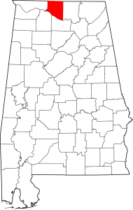
Limestone County Alabama population is 82,782. Its county seat is Athens, Alabama. Its name comes from Limestone Creek, a local stream. Limestone County was established by the Alabama Territorial legislature on February 6, 1818. On November 27, 1821, the Alabama State legislature passed an Act that altered the boundary of Limestone County include the area east of the mouth of the Elk River with the Tennessee River. At the time, that area was a part of Lauderdale County.
Limestone County Alabama Cities:
Athens Alabama
Athens is a city in and the county seat of Limestone County. Founded in 1818 by John Coffee, Robert Beaty, John D. Carroll, and John Read, Athens is one of the oldest incorporated cities in the state, having been incorporated one year prior to the state’s admittance to the Union in 1819.
Decatur Alabama
Decatur is a city in Morgan and Limestone counties. The city, nicknamed “The River City”, is located in Northern Alabama on the banks of Wheeler Lake, along the Tennessee River. It is the largest city and county seat of Morgan County. The population in 2010 was 55,683.
Huntsville Alabama
Madison Alabama
Madison is a city located primarily in Madison County, near the northern border of Alabama. Madison extends west into neighboring Limestone County. As of the 2010 census, the population of the city was 42,938. Madison is bordered by Huntsville on nearly all sides with minor unincorporated Madison county and Limestone pockets.
Limestone County Alabama Towns:
Ardmore Alabama
Almost a century after its incorporation in 1922, the Town of Ardmore continues to have not only small town feel but small town appeal as well with a population of around 1,200 and the town limits covering a span of two square miles. It is home to the Saturn IB rocket at the Alabama Welcome Center, just south of the Tennessee border, on Interstate 65. The settlement was originally named Austin, after Alex Austin, who selected the location as a site for a station along the Louisville and Nashville Railroad.
Elkmont Alabama
Elkmont is a town in Limestone County. As of the 2010 census, the population of the town was 434, down from its record high of 470 in 2000. Elkmont began as a stop known as “Fort Hampton” along the newly-constructed Tennessee and Alabama Central Railroad in 1859. The name was changed to “Elkmont,” after the elk that once flourished in the area, in 1866.
Lester Alabama
Lester is located in northwestern Limestone County in the extreme north-central part of the state on the Alabama/Tennessee state line. According to 2016 Census estimates, Lester recorded a population of 131. The town has gained some attention for its Halloween-themed haunted house in the supposedly haunted local D. E. Jackson Memorial Hospital, which opened in the 1940s and closed in the 1990s.
Mooresville Alabama
Mooresville is a town in Limestone County, Alabama, United States, located southeast of the intersection of Interstate 565 and Interstate 65, and north of Wheeler Lake. Mooresville is one of the oldest incorporated towns in Alabama, having been incorporated on November 16, 1818, when Alabama was still a Territory. It was named for early settlers, Robert and William Moore who located on land which became the site of Mooresville. Andrew Johnson, later to become the 17th president of the United States, lived in Mooresville as an apprentice tailor when he was a young man.
Limestone County Alabama Communities:
Belle Mina Alabama
The community of Belle Mina was named for the plantation of the same name that belonged to Governor Thomas Bibb, the second governor of the state of Alabama. It was originally called “Belle Manor”, but because of southern pronunciation, the spelling changed over time. The name is derived from the French word “belle”, meaning “beautiful”. The plantation was situated along the Southern Railroad, and there was a station at or near the plantation. A post office was established in Belle Mina in 1878.The community served as the rail stop for Mooresville.
Capshaw Alabama
Capshaw, also known as Lux is an unincorporated community in eastern Limestone County. The community was named for an early settlers David and William Capshaw. A post office under the name Capshaw was first opened in 1918.
Good Springs Alabama
Good Springs is an unincorporated community in Limestone County. Coordinates: 34°56′50″N 87°11′39″W
Greenbrier Alabama
Greenbrier is an unincorporated community in south eastern Limestone County. The population is 2. Greenbrier was likely named for Greenbrier, Virginia, since a number of early settlers of the area came from Virginia. A post office was established under the name Green Brier in 1869 and was in operation until 1920.
Coordinates: 34°40′15″N 86°50′37″W
Kelly Kazek Writes:
Scenes from Greenbrier: Unspoiled farm community soon to be home to Polaris plant
Holland Gin Alabama
Holland Gin is an unincorporated community in Limestone County.
Holland Gin has been noted for its unusual place name. Holland Gin was named for a cotton gin operated by a father and son, Hezzie and Egbert Holland. Coordinates: 34°57′48″N 86°53′14″W
Oakland Alabama
Oakland is an unincorporated community in Lauderdale County. Coordinates: 34°49′39″N 87°05′07″W
Scarce Grease Alabama
Scarce Grease, also known as Scarse Grease or Rockaway, is an unincorporated community in Limestone County. Coordinates: 34°58′14″N 87°7′57″W
Tanner Alabama
Tanner is an unincorporated community in central southern Limestone County, and lies nine miles north of the city of Decatur and the Tennessee River, and four miles south of the city of Athens. Coordinates: 34°43′53″N 86°58′14″W
Veto Alabama
Veto was originally known as State Line. The community was then known as Veto, named after a community of the same name located immediately across the state line in Tennessee A post office was established under the name State Line from 1875 to 1877. A post office was then operated under the name Veto from 1882 to 1955. Veto is the northern terminus for the Richard Martin Trail.
Limestone County Alabama Ghost Towns
Center Hill Alabama
Latitude N34 51.462′ Longitude W86 47.712′
34°51’27.7″N 86°47’42.7″W
34.857700, -86.795200
Clifton Alabama
Latitude N34 59.429′ Longitude W87 06.166′
34°59’25.7″N 87°06’10.0″W
34.990483, -87.102767
Fairmount Alabama
Latitude N34 48.194′ Longitude W86 52.619′
34°48’11.6″N 86°52’37.1″W
34.803233, -86.876983
Greenbrier Alabama
Latitude N34 40.123′ Longitude W86 50.712′
34°40’07.4″N 86°50’42.7″W
34.668717, -86.845200
Hays Mill Alabama
Latitude N34 52.801′ Longitude W86 58.185′
34°52’48.1″N 86°58’11.1″W
34.880017, -86.969750
Swancott Alabama
Latitude N34 35.845′ Longitude W86 47.316′
34°35’50.7″N 86°47’19.0″W
34.597417, -86.788600
Tanner Alabama
Latitude N34 43.887′ Longitude W86 58.227′
34°43’53.2″N 86°58’13.6″W
34.731450, -86.970450
Veto Alabama
Latitude N35 59.678′ Longitude W86 59.326′
35°59’40.7″N 86°59’19.6″W
35.994633, -86.988767
Westmoreland Alabama
Latitude N34 56.762′ Longitude W87 12.832′
34°56’45.7″N 87°12’49.9″W
34.946033, -87.213867
Wooley Springs Alabama
Latitude N34 54.169′ Longitude W86 47.506′
34°54’10.1″N 86°47’30.4″W
34.902817, -86.791767
Limestone County Alabama Historic Destinations
The Donnell House – Athens Alabama
Fort Henderson Historic Site and Trinity High School – Athens Alabama
Mooresville Alabama Post Office – Mooresville Alabama
Alabama Veterans Museum and Archives – Athens Alabama
Limestone County Alabama Weblinks
1818 Farms
24889 Lauderdale Street
Mooresville, AL 35649
email: info@1818farms.com
phone: 256.489.0777
We do not have set hours that we are open. However, we are available for scheduled Guided Tours. Please click here to learn more.
Limestone County is located in the rolling foothills of the Appalachian Mountains. The County is in the center of the Tennessee Valley with the Tennessee River running along the southern end of the county. The county name comes from a large creek, which flows through it, its bed of hard limestone.
Athens, AL 35611
Phone: (256) 232-2720
Email: assist@athensnews-courier.com
No matter how you spell it - barbeque, barbecue, bbq, or bar-b-que, a visit to the Tennessee Valley area just isn't complete until you've sat down for some authentic southern style cooking you get at Greenbrier Restaurant. Whether you are a casual diner or a barbecue expert, you are sure to delight in Greenbrier Restaurant's selection of tender and juicy pork, ribs, chicken or ham.
Limestone County is included in the Huntsville, AL Metropolitan Statistical Area.

