Coosa County Alabama
Coosa County Alabama

Located in east-central Alabama, Coosa County population is 11,539. As of the 2000 census, 66 percent of the population is white, 31 percent African American, 2 percent Hispanic. The county was one of 14 counties organized from lands ceded by the Creek Indians in the 1832 Treaty of Cusseta. Its county seat, originally named Lexington, located on Hatchet Creek, was renamed to Rockford in 1835.
Coosa County is home to Lay Lake, Lake Martin and Mitchell Lake. The county has extensive placer gold prospect areas with a significant history of mining during the early gold rush days in Alabama. Rich placer gold occurred along Weogufka Creek and Hatchet Creek.
Coosa County Alabama at a Glance
| Established: | December 18, 1832 |
| Source: | Created from ceded Indian lands in 1832. |
| Area (square miles): | 657 |
| Population (2010 census): | 11,539 |
| Major waterway(s): | The Coosa River is one of the most developed rivers in Alabama. Approximately 280 miles long, the Coosa River begins in Rome, Georgia and meanders about 28 miles west until it crosses into Alabama. Flowing approximately 252 miles through Alabama, the Coosa joins the Tallapoosa River, just south of Wetumpka, to form the Alabama River. The Coosa River gives Coosa County its name and defines the western border of the county on its way to Montgomery. |
| Major highway(s): | U.S. Route 280, U.S. Route 231. |
| County seat: | Rockford |
| Largest city: | Goodwater |
Coosa County Alabama History
Source: Alabama As It Is by Benjamin Franklin Riley, D. D., 1887
The county of Coosa derives its name from the beautiful river of the same name which forms its western boundary. In admiration of the sparkling water of the stream, the Indians named it rippling which is the translation of Coosa. The county was organized in 1832. It partakes largely of the characteristics which prevail in the adjoining counties. Both as a mineral and agricultural county, Coosa is greatly favored. It has an area of 670 square miles.
Population in 1870, 11,945; population in 1880, 15,113- White, 10,050; colored, 5,063.
Tilled Land; 80,791 acres. Area planted in cotton, 26,468 acres; in corn, 29,990 acres ; in oats, 5,325 acres; in wheat, 9,735 acres; in tobacco, 28 acres; in sweet potatoes, 412 acres.
Cotton Production: 8,411 bales.
The face of the country is uneven, being diversified with precipitous hills, deep valleys, beautiful terraces, with broad districts of undulating surface. The character of the soils is varied. The dominating lands are the red and gray, with occasional belts of thinner soils, which are mostly found along the hills and ridges. There are also many broad and beautiful valleys iu the county, the productiveness of which exceeds that of any other lands. Upon the lands which skirt the streams are found the splendid cotton fields of Coosa, as well as upon the best red and gray uplands. These valleys have a considerable depth of rich soil, mixed with vegetable matter—the accumulations of ages. The principal crops are cotton, corn, oats, wheat, sweet potatoes, and sorghum. The three crops first named grow to rank luxuriauce when planted upon lands favorable to their production. The soil is capable of producing valuable grasses, and the fine stock in which the county abounds shows what may be accomplished in this branch of industry.
Near the center of the county, between two of its principal streams, are found many high ridges which are clad in the noblest specimens of yellow or long-leaf pine. This district of valuable timber extends to the Talladega line. The other timbers comprise several kinds of oak and hickory, together with occasional patches of short-leaf pine.
Embosomed in the numerous high hills, already mentioned, which prevail between Weoguffka and Hatchet creeks, are deposits of iron ore which seem inexhaustible. A granite belt of value exists between the towns of Bradford and Rockford. Tantalite, copper, tin, asbestos, emery, soapstone, corundum, kaolin, with traces of gold and silver, are also found.
At Kellyton is a thriving cotton-mill, known as the Bradford Factory. Water-power is abundant in the multitude of streams that flow through Coosa, chief among which are Coosa river, Hallet, Weoguffka, and Paint creeks. Rockford, Kellyton, Bradford, Nixburg, and Goodwater are the principal towns. The Columbus and Western railroad terminates, at present, at the last-named place. The road is projected to the vast Tennessee, Virginia, and Georgia railroad. The Anniston and Atlantic railroad is also being built to this point.
School and religious facilities abound throughout the county, and at several of the towns named are schools of more than ordinary grade. The people are hospitable, and favorably disposed toward strangers seeking homes in their midst.
Lands vary in price from $2 to $12 per acre, their value depending upon their grade and location. Coosa is a county of radiant promise, and, when its internal wealth shall be known, it will be brought up alongside the most progressive counties in the State. It deserves high consideration at the hands of those seeking a favorable location for settlement. In the county are found 33,800 acres of government land awaiting occupation.
Coosa County Alabama Historical and Biographical Information:
Source: Northern Alabama – Historical and Biographical by Smith & De Land, Birmingham, Ala 1888 – Transcribed by Veneta McKinney
Population: White, 10,050; colored, 5,063 Area -670 square miles. Woodland, all.
Acres – In cotton 26,468; in corn, 29,990; in oats, 5,225; in wheat, 9,735; in tobacco,—- ; in sweet potatoes,—- . Approximate number of bales of cotton, 9,000.
County Seat – Rockford: population 1,000.
Newspaper published at County Seat – Enterprise (Democratic).
Post offices in the County – Bentleysville, Crewsville, Dollar, Equality, Gantt, Gold Branch, Good Water, Hanover, Hissop, Iwana, Kellyton, Lauderdale, Marble Valley, Mount Olive, Nixburgh, Pentonville, Rockford, Salter, Stewartsville, Traveler’s Rest, Weogufka.
Coosa County was established by an act of the State Legislature dated December 1832, out of a portion of the territory ceded by the Muscogee Indians by the treaty of Cusseta in March 1832. The original area of the county was much larger than its present size, as it comprised a considerable portion of that part of Elmore County which lies east of the Coosa River, which territory, with the County Seat, Wetumpka was taken from Coosa on the organization of Elmore County, in 1866.
Coosa County receives its name from the Coosa River, which in turn perpetuates the name of the beautiful and fertile valley which so charmed the eyes of De Soto and his cavaliers when their gaze first rested on it and its bosom was for the first time pressed by the foot of the white man.
The surface of the county is uneven and is marked by mountainous elevations, valleys, broad ridges containing beautiful stretches of level tablelands and sections of slightly rolling lands. The general character of the soils is red and gray, but along the hills and ridges some sandy lands are found, while in the valleys and along the bottoms of the numerous creeks, a black soil of wonderful productiveness is found, which yields cotton, corn, wheat or oats equal to the best lands of the State. These, with sweet potatoes and cane, form the principal crops raised, and while Coosa County is not regarded as one of the banner agricultural counties of the State, it is a safe county and its soil returns a yield which will average up, year in and year out, with some of the counties which stand higher than it in the agricultural scale. The red lands of this county are specially adapted to the culture of wheat and other small grain, and the yield of these articles per acre will compare favorably with the production of like crops in any other portion of the State.
The hills of Coosa County are clothed with a rich forest of long-leafed pine, with considerable oak, hickory, gum, and some short-leaf pine. Owing to the fact that this county is only entered by a railroad on its border, this forest has scarcely been touched.
Besides its agricultural features and its timber wealth, Coosa County can lay claim to distinction on account of the extent and variety of its mineral deposits. Like the county of Tallapoosa, which joins it, Coosa has gold within its borders, but none has yet been discovered in quantities which would pay to work. North of Rockford there lies a belt of granite of a superior character, which will be quarried and used largely, as soon as transportation facilities are provided to convey it to centers where it will be in demand. There is an extensive deposit of iron ore some miles north of Rockford, which at present is unavailable for the reason that it is locked in by the absence of the means of conveying it to points where it could be utilized. The other minerals, which are found in this county in greater or lesser quantities, are copper, tin, asbestos, corundum, emery, kaolin, and mica.
The principal streams of the county are the Coosa River, which forms its western boundary, Hatchett, Weogufka, Paint, Socapotoy, Pintlocco and Futtegal Creeks. These streams all furnish water-power of almost unrivaled extent. The Coosa River, where it borders this county, is rendered impassable by obstructions and rapids, and should the movement now on foot cause it to be opened to navigation, the benefit to Coosa County will be inestimable. At Bradford, on Socapotoy Creek, there is a cotton mill known as Bradford’s Factory, which has been idle for some years. The building is a substantial stone structure, and, but for the fact that it is situated so far off of the line of railroad, the property would be very valuable and the mill might be worked to advantage.
Rockford, a little town of about 1,000 inhabitants, is the County Seat. It possesses excellent schools, good society, and has several churches. Kellyton and Good Water are the only railroad stations in the county. For some years the latter has been the terminus of the Columbus & Western Railroad. This road is now being extended to Birmingham, and will be completed at an early date. The other towns of Coosa are: Nixburg, Bradford, Mt. Olive, Stewartsville, Hanover, Equality, Lorraine, Traveler’s Rest, Hissop, Weogufka and Marble Valley.
The price of land ranges from $2 to $15 per acre- The county contains a large body of public land, open to homestead settlement or purchase. The future of Coosa County is most promising, and with increased railroad facilities, and the Coosa River open to navigation, it would come to the front as one of the wealthiest counties of the State.
Coosa County Historical Destinations
Old Rock Jail Museum – Rockford Alabama
Coosa County Alabama Towns
Goodwater Alabama
Goodwater is a town in Coosa County in the northeast corner of the county in central Alabama. It is the largest city in the county. At the 2010 census the population was 1,475. It is part of the Talladega-Sylacauga Micropolitan Statistical Area.
Goodwater was first known as Adkins Gap after an early settler but became known as Goodwater because of its location near the spring that is the source of Hatchett Creek.
Goodwater is located approximately 10 miles north of Lake Martin, which offers all types of water sports, camping and rental facilities, and fishing. The Talladega National Forest lies just north of town.Hatchett Creek offers opportunities for canoeing and fishing, as well as being known for its abundant Cahaba lily blooms in spring.The Hatchett Creek Golf Course in Goodwater is a nine-hole course open to the public.
Kellyton Alabama
Kellyton is an incorporated town in Coosa County. It had a population of 217 as of the 2010 census. Kellyton was originally an outpost called Webbsville, named for the area’s first postmaster, William Webb. In 1874, the name was changed to Kellyton in honor of James Kelly, a prominent local physician.
Rockford Alabama
Rockford is a town in Coosa County, Alabama, United States. At the 2010 census the population was 477. The town is the county seat of Coosa County.
Coosa County Alabama Communities:
Dollar Alabama
Dollar is an unincorporated community in Coosa County. Dollar serviced the communities of Hatchett Creek with a mercantile store, bank, post office, cotton gin, grist mill, saw mill, and blacksmith shop, etc.
When Mitchell Dam was built, the town and surrounding farms and communities were abandoned and the post office was moved to Verbena on Nov. 20, 1921.
The same year people began leaving due to potential problems that the reservoir would bring with disease carrying mosquitoes.
Equality Alabama
Equality is an unincorporated community in Coosa, Elmore and Tallapoosa counties.
Fishpond Alabama
Fishpond is an unincorporated community in Coosa County.
Hatchet Alabama
Hatchet is an unincorporated community in Coosa County.
Marble Valley Alabama
Marble Valley is named after the Sylacauga marble found and quarried locally. A post office called Marble Valley was established in 1852, and remained in operation until it was discontinued in 1934. Marble Valley became a site for soldiers to volunteer to join the Confederate States Army from Coosa County. One soldier from Marble Valley, William Wood, wrote letters home to his family during the Civil War. After his death in a northern prison in 1863, his brothers compiled the letters and information from fellow soldiers into memoirs.
Nixburg Alabama
Nixburg is an unincorporated community in Coosa County. Nixburg was established by 1850 by Solomon Robbins, who moved there from North Carolina, and was originally called Robbinsville. It was later renamed Nixburg in honor of the Nix family, who were early settlers of the area.
The Oakachoy Covered Bridge, which was formerly listed on the National Register of Historic Places and the Alabama Register of Landmarks and Heritage, was located in Nixburg. The bridge was destroyed by vandals on June 2, 2001. The Old Shiloh Cemetery, also located in Nixburg, is listed on the Alabama Register of Landmarks and Heritage.
Hissop Alabama
Hissop is a census-designated place and unincorporated community in Coosa County. Its population was 658 as of the 2010 census.
Mount Olive Alabama
Mount Olive is a census-designated place in Coosa County. Its population was 371 as of the 2010 census.
Ray Alabama
Ray is a census-designated place and unincorporated community in Coosa County. Its population was 443 as of the 2010 census.
Stewartville Alabama
Stewartville is a census-designated place and unincorporated community in Coosa County. Its population was 1,767 as of the 2010 census.
Weogufka Alabama
Weogufka is a census-designated place and unincorporated community in Coosa County. Its population was 282 as of the 2010 census.
Coosa County Alabama Ghost Towns
Cottage Grove Alabama
Cottage Grove (GNIS FID: 116674) is a populated place located within the Hissop Census Designated Place. In turn, the Hissop CDP is located within Coosa County.
Knights Alabama
Lyle Alabama
Quinsey Alabama
Quinsey is a populated place located in Coosa County.
Coosa County Alabama Schools
|
COMMUNITY / PLACE NAME
|
LOCATION
|
| Aucheucaula (historical) | 33.020833, -86.511111 |
| Batson Post Office (historical) | Unknown |
| Baxley Mountain | 33.013889, -86.308611 |
| Bazemore Crossroad (historical) | 33.016111, -86.323889 |
| Bentleyville | 32.956111, -86.260278 |
| Big Rock Island | 32.915556, -86.505278 |
| Blackmons Landing | 32.918889, -86.496667 |
| Blue Springs | 33.073333, -86.478056 |
| Bradford | 32.994722, -86.085000 |
| Bryant | 32.838333, -86.370556 |
| Callaway Post Office (historical) | Unknown |
| Candler Mountain | 33.074444, -86.011944 |
| Cedar Island (historical) | 32.987500, -86.511944 |
| Coosa Valley | 32.483333, -86.266667 |
| Cottage Grove | 32.855556, -86.122500 |
| Crewsville | 32.943333, -86.136667 |
| Darden (historical) | 32.849167, -86.030833 |
| David (historical) | 32.757778, -86.044167 |
| Deadening Mountain | 33.009722, -86.413056 |
| Dent Post Office (historical) | Unknown |
| Dollar | 32.878611, -86.424167 |
| Draw Post Office (historical) | Unknown |
| Edison Post Office (historical) | Unknown |
| Edward (historical) | 32.951111, -86.050000 |
| Equality | 32.761944, -86.101944 |
| Estille Post Office (historical) | Unknown |
| Fig Grove Post Office (historical) | Unknown |
| Fishpond | 32.867778, -86.023333 |
| Fixico Post Office (historical) | Unknown |
| Flag Mountain | 32.978056, -86.354722 |
| Foshee Islands | 32.918889, -86.504167 |
| Gilchrist Island | 32.928056, -86.510556 |
| Gill Post Office (historical) | Unknown |
| Goat Island | 32.870278, -86.454444 |
| Gold Branch | 32.994167, -86.387500 |
| Goodwater | 33.060833, -86.051667 |
| Gum Island | 32.460000, -86.313056 |
| Hanover | 33.004722, -86.202500 |
| Hanover Post Office (historical) | Unknown |
| Hatchet | 33.016667, -86.105000 |
| Hidden Valley | 32.990278, -86.495556 |
| Higgins Ferry (historical) | 32.863611, -86.451111 |
| Hillwood | 32.925278, -86.361389 |
| Hilyer Post Office (historical) | Unknown |
| Hissop | 32.892222, -86.153333 |
| Holman Crossroads | 33.104167, -86.192500 |
| Houses Island | 32.867500, -86.458333 |
| Island Ford | 32.886667, -86.270278 |
| Iwana Post Office (historical) | Unknown |
| Jon | 32.893889, -86.031111 |
| Kellys Crossroads | 32.837222, -86.334444 |
| Kellyton | 32.979167, -86.035833 |
| Keyno | 32.936944, -86.109167 |
| Knights (historical) | 32.791667, -86.404722 |
| Lauderdale Post Office (historical) | Unknown |
| Little Rock Island | 32.916944, -86.503889 |
| Locust Mountain | 33.058333, -86.188611 |
| Looneys Mill (historical) | 33.090000, -86.436111 |
| Loraine Post Office (historical) | Unknown |
| Lyle | 32.888611, -86.335278 |
| Manning Post Office (historical) | Unknown |
| Marble Valley | 33.043889, -86.451944 |
| Mims Ferry | 32.952778, -86.515278 |
| Moriah | 32.933611, -86.345833 |
| Mount Mariah Post Office (historical) | Unknown |
| Mount Olive | 33.069444, -86.135000 |
| Nixburg | 32.827778, -86.111111 |
| Oakachoy Covered Bridge | 32.848889, -86.055556 |
| Oakchoy Post Office (historical) | Unknown |
| Okchayi (historical) | 32.820833, -86.016667 |
| Pages Old Ferry (historical) | 32.984444, -86.510833 |
| Parkdale | 33.097778, -86.112222 |
| Pentonville | 32.815556, -86.227778 |
| Pentonville Post Office (historical) | Unknown |
| Piedmont Upland | 33.083333, -85.833333 |
| Pindar Post Office (historical) | Unknown |
| Pinthlocco (historical) | 32.838889, -86.211111 |
| Poken Tallassee Council House (historical) | 32.842778, -86.403056 |
| Proctor Post Office (historical) | Unknown |
| Quinsey | 32.949444, -86.464444 |
| Ray | 32.887222, -86.037778 |
| Reedy Mountain | 33.014167, -86.428056 |
| Richville | 32.815000, -86.318333 |
| Rockford | 32.889444, -86.215000 |
| Salter Post Office (historical) | Unknown |
| Schley | 32.793056, -86.370000 |
| Scott Ford | 32.936944, -86.251944 |
| Sehoya | 32.978333, -86.484722 |
| Smiths Ferry (historical) | 33.830556, -86.459722 |
| Smyrna Hill | 33.057222, -86.010000 |
| Socapatoy | 32.986389, -86.067222 |
| Soleo | 33.013611, -86.035278 |
| Speed | 32.774722, -86.231944 |
| Spoke Post Office (historical) | Unknown |
| Stewartville | 33.079167, -86.244444 |
| Strickland Crossroads | 33.062778, -86.386111 |
| Terrapin Hill | 33.013333, -86.250000 |
| The Narrows | 33.042500, -86.516667 |
| Thelma Post Office (historical) | Unknown |
| Travelers Rest | 32.819444, -86.330556 |
| Tyler Ford | 32.911944, -86.283611 |
| Unity | 33.005278, -86.359167 |
| Varnerton Post Office (historical) | Unknown |
| Ware Island | 32.945556, -86.514167 |
| Welona | 32.766667, -86.336111 |
| Weogufka | 33.016389, -86.312222 |
| Weogufka (historical) | 32.944444, -86.365278 |
| Weogufka Mountains | 32.933333, -86.308333 |
| Weoka | 32.717500, -86.184167 |
| York Mountain | 33.029722, -86.395556 |
Properties on the Alabama Register of Landmarks and Heritage in Coosa County Alabama
Site name * Date listed * City or Town * Built or Established * NRHP/NHL
- Coosa County Farmers and Civic Association Building September 25, 2008 c. 1929
- Coosa County Training School September 26, 2003 Rockford
- Double Bridges September 26, 2003 Weogufka vicinity c. 1934
- Franklin Store (Goodwater Feed & Seed) June 18, 2016 Goodwater c. 1904
- Lay Dam February 19, 1976 Coosa River c. 1910–1914
- Mims Ferry September 5, 1975 Coosa River c. 1895, 1957
- Oakachoy Covered Bridge (Destroyed by fire 2001) October 28, 1977 Nixburg vicinity c. 1915 Delisted
- Old Rockford Elementary School September 30, 1999 Rockford 1927
- Old Shiloh Cemetery March 24, 1995 Nixburg vicinity 1836
- James Powell House November 13, 1996 Rockford
- Rockford Women’s Club House March 13, 1996 Rockford 1932
- Smyrna Primitive Baptist Church Cemetery July 30, 1981 Goodwater
- Weogufka State Park July 18, 1989 Weogufka c. 1930
Coosa County Alabama Schools
|
SCHOOL NAME
|
LOCATION
|
| Adams Elementary School | 32.894444, -86.227778 |
| Alabama Masonic Institute (historical) | Unknown |
| Blue Springs School (historical) | 33.072500, -86.474722 |
| Central High School | 33.003611, -86.198333 |
| Coosa County High School | 32.888611, -86.222222 |
| Coosa County Vocational Center | 33.001389, -86.202222 |
| Crossroads School | 33.047500, -86.084722 |
| Equality Junior High School (historical) | 32.763889, -86.104444 |
| Estelle School (historical) | 33.060278, -86.308889 |
| Goodwater Academy | 33.077778, -86.068056 |
| Goodwater Elementary School | 33.066111, -86.043056 |
| Goodwater High School | 33.066944, -86.043056 |
| Hatchet Springs School | 33.018611, -86.103889 |
| J D Thompson High School | 32.855278, -86.123056 |
| Kellyton Junior High School | 32.980000, -86.036944 |
| Marietta School | 33.020556, -86.036111 |
| Marja School (historical) | 32.933333, -86.039167 |
| Richville Junior High School (historical) | 32.807778, -86.323333 |
| Union Academy (historical) | 32.801944, -86.151944 |
| Weogufka High School | 33.019444, -86.314722 |
| West Coosa Elementary School | 33.070278, -86.250833 |
Coosa County Alabama Records
Clerk of Circuit Court, P.O. Box 218, Rockford, AL 35136,Phone (256) 362-5721
Court Records call for information.
Clerk of Probate Court, PO Box 218, Rockford, AL 35136
Marriage Records from 1834, Probate Records from 1834 and Land Records from 1832
Coosa County Health Department
Birth Records from 1878, Death records from 1920
Coosa County Alabama Weblinks
Very rural county with an abundanceof natural resources‐ forestland, pastures, ponds, lakes, streams, wildlife and fish.
Coosa County, Alabama ALGHN
The Coosa County, Alabama website of the Alabama Genealogy & History Network.
Coosa County, Alabama Marriages
Coosa County, Alabama marriages at Coosa County, Alabama Genealogy & History Network.
Coosa County, Alabama Cemeteries
Coosa County, Alabama cemetery information from Coosa County, Alabama Genealogy & History Network.
Coosa County, Alabama Communities
List of Coosa County, Alabama communities and their locations from Coosa County, Alabama Genealogy & History Network.
Coosa County, Alabama Churches
Coosa County, Alabama churches and their locations provided by Coosa County, Alabama Genealogy & History Network.
Coosa County, Alabama Important Addresses and Links
Important addresses and links for Coosa County, Alabama provided by Coosa County, Alabama Genealogy & History Network.
Coosa County, Alabama Map
Coosa County, Alabama map at Coosa County, Alabama Genealogy & History Network.
Coosa County, Alabama Rivers, Lakes & Streams
Coosa County, Alabama Rivers, Lakes & Streams and their locations.
Coosa County, Alabama Schools (including Historical)
List of Coosa County, Alabama schools and their locations from Coosa County, Alabama Genealogy & History Network.
Coosa County, Alabama Search
Search results for Coosa County, Alabama at the Alabama Dept. of Archives & History’s online catalog.
NACO: Coosa County, Alabama
Coosa County, Alabama information from the National Association of Counties.
Coosa County, Alabama Census Online
Coosa County, Alabama census resources online.
ePodunk: Coosa County, Alabama
Coosa County, Alabama resources from the folks at ePodunk.
Family History Centers
Search for Family History Centers serving Coosa County, Alabama.
ALGenWeb: Coosa County, Alabama
Coosa County, Alabama County project of the ALGenWeb.
The Political Graveyard
Coosa County, Alabama facts and information.
Coosa County, Alabama RootsWeb Message Board
Coosa County, Alabama message board hosted by RootsWeb.
Coosa County, Alabama Tombstone Transcription Project
Coosa County, Alabama tombstone transciptions.
Coosa County, Alabama USGenWeb Archives
For Coosa County, Alabama.
Wikipedia article on Coosa County
(if this link doesn’t work, find the new one through the USGenWeb national site).
Coosa County Alabama Additional Information
Coosa County history page: Alabama Department of Archives and History.
Coosa County: The Encyclopedia of Alabama TM & © 2013. Alabama Humanities Foundation. All Rights Reserved. A service of Auburn University, The University of Alabama, and Alabama State Dept. of Education.
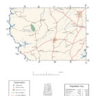
Map: Coosa County’s major roads and towns. : Prepared by the Department of Geography, College of Arts and Sciences, The University of Alabama.
General Highway Map: Coosa County, Alabama: Prepared by the Alabama Department of Transportation, Bureau of Transportation Planning, Surveying and Mapping Division in cooperation with the U.S. Department of Transportation.
Coosa County, Alabama Genealogical Information: The USGenWeb Project: Keeping Internet Genealogy Free.
Coosa County, Alabama: United States Census Bureau: State & County QuickFacts.
Coosa County: National Association of Counties (NACO).
Autauga County Commission: Official website of Coosa County, Alabama.
Rockford: The Encyclopedia of Alabama TM & © 2013. Alabama Humanities Foundation. All Rights Reserved. A service of Auburn University, The University of Alabama, and Alabama State Dept. of Education.
Rockford, Alabama: Entry for Rockford at Wikipedia, the free encyclopedia.
Alabama County Web Sites: State of Alabama: Alabama Directory.
Alabama County Selection Map: United States Census Bureau: State & County QuickFacts.
Alabama County Map with County Seat Cities: Geology.com.
Maps of Alabama Counties: University of Alabama: Alabama Maps.
Alabama Counties from Amazon.com
Coosa County Alabama Arrest Records