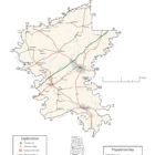
Greene County Alabama
Greene County Alabama

Greene County Alabama population is 9,045. making it the least populous county in Alabama. Its county seat is Eutaw, Alabama.
Greene County was created by an act of the Alabama on December 13, 1819, from lands ceded to the federal government by the Choctaw Indian Cession of 1816. The county was named for Revolutionary War hero Nathaniel Greene, and the county seat, Eutaw, was named for the Battle of Eutaw Springs, in which Greene led his troops in the recapture of Charleston, South Carolina, from the British.
Comprising approximately 631 square miles, Greene County lies in the west-central area of the state. It is bounded to the north by Pickens County and Tuscaloosa County, to the east by Hale County, to the south by Marengo County, and to the west by Sumter County.
The Tombigbee River flows along the western border of the county, and its tributary, the Sipsey River Swamp flows along the northern border. Other tributaries of the Tombigbee, including Taylor, Brush, and Trussells creeks, also intersect the county. The Black Warrior River runs along the eastern border until it meets the Tombigbee at Demopolis, just below the southern tip of Greene County, in Marengo County.
Greene County Alabama History
Source: Alabama As It Is by Benjamin Franklin Riley, D. D., The Brown Printing Co, State Printers and Binders, 1893
GREENE COUNTY.
HAVING been established in 1819, the county was named in honor of General Nathanael Greene, of Rhode Island. The territory of the county lies in the fork of the Warrior and Tombigbee Rivers, and extends as far north as the Sipsey River, which forms a part of its northern boundary. A county so highly favored with water-ways, exceedingly fertile lands, and high social advantages, offers an inviting home to the immigrant and investor. It has an area of 520 square miles.
Population in 1880, 21,931; population in 1890, 22,007. White, 3,235; colored, 18,772.
Area planted in Cotton—76,384 acres; in corn, 31,034 acres; in oats, 2,398 acres; in rye, 6 acres. Cotton Production—20,901 bales.
With few exceptions the territory of Greene county forms a vast rolling prairie of surpassing fertility. In the northern end of the county there is a broken surface which slopes away into a gentle undulation towards the south. Along the Warrior River, on the east, there are bottoms of the most prolific soils, while back toward the west there is a gradual ascent to the beautiful tablelands, which are overspread with rich, brown, loam soil, and which have a red clay subsoil.
The most fertile lands lie in the southern and southwestern portions of the county. With the most indifferent method of tillage, they yield from twenty-five to sixty bushels of corn per acre, and from thirty to sixty bushels of oats. Clovers and grasses abound. Among these may be named the red clover, mellilotus and Japan clover. The mellilotus alba—a Chilian herb—grows luxuriantly in this region upon the rocks that have been denuded of all surface soil. So rapidly does it thrive that it may be cut with the scythe three times a year. It is relished above all other herbage by stock. In almost every portion of the county grasses and clovers thrive with great readiness.
In the lower part of the county, where the Tombigbee receives the Warrior, which portion is called the “fork,” there is a very productive section of alluvial lands, with here and there a sandy ridge overspread with pebble. This was regarded the most noted cotton section in the county before the war, and its capabilities are still unimpaired; but the change of labor has not been favorable to the cultivation of these heavy, fertile lands. The chief crops upon the several soils of Greene county are cotton, corn, oats, sweet and Irish potatoes, and sugar cane. The last-named production is annually increasing. It thrives luxuriantly in the bottoms, is easy to cultivate, and is readily and cheaply converted into first-class molasses and sugar. The bottoms in the northern portion of the county are extensively used in its production. As will be seen from the statistics given above, about two-thirds of the lands of Greene are devoted to cotton. The county is emphatically a cotton producing section, but its soils are capable of producing any crop grown upon the lands of the South. Corn grows to perfection. Grasses and clovers, both wild and domestic, flourish luxuriantly; the streams and low places form dense brakes of swamp cane, and thus stock-raising is easy. For many years attention has been given to raising stock.
With the means of transportation at hand, there is no doubt that stock-raising would be the most lucrative industry in which one could engage in Greene couDty. The timbers in the forests embrace pine, oak, hickory, beech, cypress, cedar, ash, and gum. Fruit trees grow finely and produce well in some parts of the county. Navigable Rivers—the Tombigbee and the Warrior— flow along its western and eastern boundaries, while the Alabama Great Southern Railroad penetrates the county, east and west, and together they present to commerce floe facilities for transportation.
The county is drained by numerous streams which flow into the three rivers, by which it is, in large measure, surroundedAmong these may be named Sim’s, Buck’s, and Turkey Creeks.
The principal towns are Eutaw, the county-seat, with a population of 1,200; Forkland, Clinton, Pleasant Ridge, and Union, all of which are increasing in importance as social and Commercial centers.
Eutaw has good schools and churches, and a hotel which has won for itself quite a distinction with the traveling public. At all the points named, good schools are to be found, and throughout the country districts the people are alive to the importance of education. Because agricultural lands have not been in demand by immigrants in Central Alabama since the close of the war, and because these lands have not been put upon the market, there has been very little sale, and hence the lands are cheap. They may be purchased at prices ranging from $3 to $13 per acre, and yet their capabilities are remarkable. Before the war these lands could not have been bought for $25 and $50 per acre. Extraordinary inducements are here given to immigrants of thrifty habits. Natural fertilizers prevail in different portions of Greene. There is a green sand bed at Pleasant Ridge. Along the banks of the Warrior River at low water there is exposed a bed of green sand between Choctaw Bluff and Erie. This bed is several feet thick, and with the development of the agricultural resources of the county, will prove valuable.
Of late there has been a discovery of considerable beds of Marl and green sand on the dividing line between the clay and the black lands. The extent of these beds is unknown, but they are in thickness from three to ten feet. Experiments of their merits having been made, prove them quite valuable as fertilizers even in their crude state.
Greene county is justly regarded one of the most productive of the counties of this belt. There are about 280 acres of government land in the county.
Source: Northern Alabama – Historical and Biographical by Smith & De Land, Birmingham, Ala 1888
GREENE COUNTY.
Population: White 3,765; colored 18,166. Area 520 square miles. Woodland all, except about twenty-five square miles of prairie.
Acres – In cotton (approximately) 63,643: in corn 31,826; in oats 2,163; in wheat 214; in rye 25; in sugar-cane 25; in tobacco 41; in sweet potatoes 705. Approximate number of bales of cotton, 15,800
County seat – Eutaw; population 1,100; situated on the Alabama & Great Western Railroad, thirty-five miles from Tuscaloosa, and sixty miles west of Selma.
Newspapers published at County Seat – Mirror, Whig and Observer (all Democratic).
Post offices in the County – Boligee, Burton’s Hill, Clinton, Dobbs, Eutaw, Forkland, Knoxville, Mantua, Mount Hebron, Pleasant Ridge, Tishabee, Union, West Greene.
The county bounded is on the north by the Sipsey River, on the east and southeast by the Warrior River, and on the west and southwest by the Tombigbee River; is situated in the western part of Alabama, and, agriculturally considered, is one of the best counties in the State. Its county seat, Eutaw, is situated on the Alabama Great Southern Railroad, and three miles west of a steamboat landing on the Warrior River. Its other towns are Forkland, 300 inhabitants, in the southern part of the county, near the junction of the Warrior and Tombigbee Rivers; Boligee, on the Alabama Great Southern Railroad, 300 inhabitants: Mount Hebron, West Greene and Pleasant Ridge, in the western part of the county, near the Tombigbee River, each containing about 150 inhabitants: Knoxville, 200 inhabitants, and Union and Mantua, two small villages in the northern part of the county. The Alabama Great Southern Railroad crosses the county from east to west. The lands lying south of this railroad, with a few exceptions, are what are known as “canebrake lands” and much resemble the prairies of the North and Northwest. They are very productive, an average crop being one-half bale of cotton or thirty bushels of corn per acre. These lands are worth from six to fifteen dollars per acre, according to locality and fertility. North of the river is a small belt of black or canebrake lands, but the main body of the lands lying north of this railroad are either dark red or gray sandy lands. These sandy lands are good for all kinds of farming, and respond generously to judicious fertilizing. They are worth from two to twelve dollars per acre, according to locality and quality. The principal products of the county are corn, cotton, peas, potatoes, molasses, and vegetables. Large bodies of cane are to be found upon the uncleared lands of this county, which form a splendid winter pasture for stock, and owing to the splendid climate, fertility of soil and abundance of water, and its adaptability to the growth of clover, this county would be a splendid locality for stock raisers. Greene County contains large bodies of virgin timber, consisting of oak, red and white, ash, poplar, cypress, hickory and pine, and the Sipsey, Warrior and Tombigbee Rivers would be splendid places for the lumber mills. Greene County lies seventy miles south of Birmingham, and “truck farming” there would yield good and immediate profits.
Among the great men given to the State by this county are to be mentioned the brilliant advocate, William M. Murphy: the eminent jurist, John Erwin: the well-known Chancellor Clark. These men are now dead. Among the living are to be mentioned Thomas Seay, the present Governor of Alabama, who was born in Greene County, and Thomas W. Coleman, the present efficient Chancellor of the Southwestern Chancery Division of this State. Educational and religions facilities of the county are good.
Greene County Alabama Cities:
Eutaw Alabama
The town of Eutaw was settled around the same time that Greene County itself was created on December 13, 1819, and was originally known as Mesopotamia.
Greene County Alabama Towns:
Boligee Alabama
Boligee is a town in Greene County, Alabama, United States. At the 2010 census the population was 328, down from 369 in 2000. Although Boligee appeared on the 1880 U.S. Census, according to the 1930 U.S. Census it did not incorporate until 1926, though another source cited 1927.
Forkland Alabama
Forkland, which was incorporated in 1974, is a tiny rural town in Greene County, Alabama. Even though it’s small in size, this town offers a lot of charm. Forkland is located in southern Greene County and is home to 629 people, 245 households, and 161 families as of 2000. Forkland is best known for the anual biker event called the Bama Bike Fest.
Union Alabama
Union is a town in rural Greene County. At the 2010 census the population was 237, up from 227 in 2000. According to the 1980 U.S. Census, it was incorporated in the 1970s.
Greene County Alabama Communities:
Clinton Alabama
Clinton is an unincorporated community in Greene County. Clinton is located at the junction of Alabama routes 14 and 39, 7.9 miles northwest of Eutaw. Clinton has a post office with ZIP code 35448.
Crawford Fork Alabama
Crawford Fork is a small unincorporated community in Greene County. It lies at an elevation of 131 feet.
Jena Alabama
Jena is an unincorporated community in Greene County.
Knoxville Alabama
Knoxville is an unincorporated community in Greene County. Knoxville is located at the junction of Interstates 20 and 59 with U.S. Routes 11 and 43, 11.9 miles (19.2 km) north-northeast of Eutaw. Knoxville had a post office until it closed on August 29, 2009; it still has its own ZIP code, 35469.
Mantua Alabama
Mantua is an unincorporated community in Greene County.
Mount Hebron Alabama
Pleasant Ridge Alabama
Pleasant Ridge, also known as Ridge, is an unincorporated community in Greene County. Pleasant Ridge is located on Alabama State Route 14, 17.2 miles (27.7 km) northwest of Eutaw.
A post office operated under the name Pleasant Ridge from 1825 to 1918. On April 6, 1865, there was a skirmish between Union forces under the command of Brigadier General John T. Croxton and Confederate forces under the command of Brigadier-General William Wirt Adams near Pleasant Ridge. Croxton was leaving Tuscaloosa, having burned the University of Alabama on April 4. The 6th Kentucky Cavalry Regiment and the 2nd Michigan Volunteer Cavalry Regiment engaged with Adams’ forces. Union casualties were three killed in action, eight wounded, sixty-eight captured. Adams’s Confederate force suffered nine killed, twenty-five wounded, and one captured.
West Greene Alabama
West Greene, also known as Boston, Hopewell, Old West Greene, and Westgreene, is an unincorporated community in Greene County. It lies at an elevation of 164 feet (50 m). The post office in West Greene first opened in 1879.
Greene County Alabama Ghost Towns
Baltzell Alabama
Latitude N32 37.970′ Longitude W87 55.958′
32°37’58.2″N 87°55’57.5″W
32.632833, -87.932633
Jena Alabama
Latitude N33 07.838′ Longitude W87 50.815′
33°07’50.3″N 87°50’48.9″W
33.130633, -87.846917
Lewiston Alabama
Latitude N33 02.460′ Longitude W88 01.216′
33°02’27.6″N 88°01’13.0″W
33.041000, -88.020267
Lizzieville Alabama
Latitude N32 47.255′ Longitude W88 01.729′
33°02’27.6″N 88°01’13.0″W
33.041000, -88.020267
McClure Alabama
Latitude N32 50.786′ Longitude W87 50.537′
32°50’47.2″N 87°50’32.2″W
32.846433, -87.842283
Miller Alabama
Latitude N32 42.759′ Longitude W88 04.717′
32°42’45.5″N 88°04’43.0″W
32.712650, -88.078617
Watonia Alabama
Latitude N32 41.192′ Longitude W87 55.884′
32°41’11.5″N 87°55’53.0″W
32.686533, -87.931400
Greene County Historic Destinations
SCLC Magnolia House –
702 Greensboro St.,/ AL Hwy 14 E, Eutaw, AL 35462 (GPS Coordinates: N32.8406848, W-87.8875145)
Telephone: (205) 372-3446, (205) 372-9073, or (205) 826-6684
An extension of the Alabama Civil Rights Freedom Farm Museum, contains three civil rights houses.
Alabama Civil Rights Freedom Farm Museum – Eutaw
Greene County Alabama Historic Places:
Anthony, David Rinehart, House
(added 1982 – – #82002015)
307 Wilson Ave. , Eutaw
Boligee Hill
(added 1982 – – #82002014) Also known as Myrtle Hall SE of Boligee , Boligee
Braune, Gustave, House
(added 1982 – – #82002016) 236 Prairie St. , Eutaw
Carpenter, Capt. Nathan, House
(added 1999 – – #99000793) Also known as Twin Oaks Plantation 2.5 mi. SE of Clinton , Eutlaw
Cockrell, Samuel W., House
(added 1982 – – #82001618) 210 Wilson St. , Eutaw
First Presbyterian Church
(added 1974 – – #74000411) Main St. and Wilson Ave. , Eutaw
Greene County Courthouse
(added 1971 – – #71000098) Courthouse Sq. , Eutaw
If you would like to become a sponsor, advertise a related location, service or vacation spot that would add to the usefulness of this site, please email us: staff@digitalalabama.com.