LAUDERDALE COUNTY ALABAMA
Lauderdale County Alabama

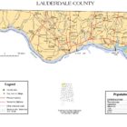
Lauderdale County Alabama is located is the extreme northwest county of Alabama. It’s population is 92,709 and its county seat is Florence Alabama. Its name is in honor of Colonel James Lauderdale, of Tennessee.
Lauderdale County was established in 1818, a year before Alabama became a state, Florence, the county seat of Lauderdale County, was also established in 1818. At this time a group of investors, under the name of Cypress Land Company purchased from the government 5,515 acres of land consisting of the original town site. Other towns in Lauderdale County competing for early settlers because of their proximity to the river were Savage’s Spring, nine miles below Florence and Waterloo, some 20 miles downriver.
A History Of Lauderdale County Alabama
Source: Northern Alabama Historical & Biographical
by T.A. DeLand and A. Davis Smith, Birmingham AL, 1888Haywood’s History of Tennessee says that the portion of Alabama, north of the Tennessee, was organized into a county by the Georgia Legislature in 1785 and called Iloustoun, in honor of John Houstoun, governor of that state in 1778 and 17S4. A party of eighty men came down the Tennessee shortly after, and effected a settlement at a point on the Muscle Shoals within the present limits of this county. They opened a land office, elected one of their number to the Georgia legislature, and performed other right of citizenship. But within a fortnight the settlement was abandoned in dread of the warlike Chicasas. The region now embraced within this country was the scene of several bloody skirmishes between the Tennesseeans and Chicasas about the years 1787-90.
During the war between the States a cavalry fight occurred two miles east of Florence, in which the cavalry regiment of Col. Wm. A.Johnson, of Colbert, scattered a federal command with some loss to it. Near the same spot the army of Gen. Hood lay encamped for several weeks just before entering on the disastrous campaign which culminated at Franklin and Nashville. Lauderdale, then in common with the other counties of the Tennessee valley, suffered fearfully inconsequence of its exposed position.
Probably no single county in the State can boast a higher order of citizenship than Lauderdale, while her past history is replete with the names of men whose brilliant achievements illumine the annals of a nation. The brave old soldier. Gen. John Coffee, Jackson’s most trusted lieutenant, lived and died here; Robt. Miller Patton, one of Alabama’s greatest governors, made this his home, while the distinguished soldier, statesman and citizen, Edward Asbury O’Neal yet resides at Florence. Caroline Lee Hentz, whose memory is so dear to every lover of a pure literature, spent nine years of herttfe here. Judge John Edmund Moore, Wade Keys, Hugh McVay, Sidney C. Posey, James Jackson, James Irvine, and many others whose names are identified with the history of Alabama, were citizens of this county.
Lauderdale County Alabama Cities:
Florence Alabama
Florence is a city in, and the county seat of, Lauderdale County, Alabama, in the state’s northwest corner. Florence is the largest and principal city of the Florence-Muscle Shoals Metropolitan Statistical Area. Florence is considered northwestern Alabama’s primary economic hub.
Lauderdale County Alabama Towns:
Anderson Alabama
Anderson Alabama is situated along Anderson Creek, which empties into the Elk River near the Lauderdale-Limestone county border. Both the town and creek were named for Samuel Anderson, who built a gristmill along the creek in the early 19th century. The town was first settled around 1825 and was named Andersons Creek for the afore mentioned creek. The name was shortened to Anderson, and a post office was established in 1860. Anderson incorporated as a town in 1973.
7262 Highway 207
Anderson, Alabama 35610
(256) 247-3617
Killen Alabama
Killen is a town located in Lauderdale County, Alabama. It is part of the Florence-Muscle Shoals Metropolitan Statistical Area known as “The Shoals”. It was incorporated in 1957 and has a population of 1,108.
Killen was settled in the early 1800s. In 1826, Joseph Mason was appointed the first postmaster of the new community called Masonville, later to become Killen. The post office existed until 1866. In the 1830s the construction of the Alabama Canal brought growth to the area. The canal was built to solve the navigation problems created by the shoals in the Tennessee River. Construction on the new canal began in 1875 and the 14 1/2 – mile canal, with nine locks with a lift of 85 feet, opened November 10, 1890. The canal was renamed the Muscle Shoals Canal. Lock six served as the headquarters and was located just 1/2- mile south of Killen. The canal system had a major economic impact on the development of Killen. Many of the citizens were employed on the canal and others supplied raw materials and food for the operation.
Lexington Alabama
Lexington is a town in Lauderdale County. It is part of the Florence – Muscle Shoals Metropolitan Statistical Area known as “The Shoals”. It incorporated in 1959. As of the 2010 census, the population of the town is 735, down from 840 in 2000.
The town of Lexington was originally established on the site of four 40-acre parcels of land purchased by early settler Lewis Marshall, who arrived in 1818. The first town center was established around 1853.
Wilson Lake and Wheeler Lake are both located about 10 miles south of town. The town maintains two city parks with playground equipment, a city pool, tennis courts, and a walking trail.
Rogersville Alabama
Rogersville became an incorporated municipality on February 2, 1858. Originally known as “Rodgersville”, it took its name from Andrew and Patience Rodgers of South Carolina who moved into the area and purchased 79.8 acres (323,000 m2) at a public land sale in Huntsville on May 3, 1818. Their land eventually became what is now the downtown business district. When the Rogersville Post Office was established on October 4, 1825 with Thomas Cunningham as the postmaster, the ‘d’ was dropped from the town’s name and it has been known as Rogersville ever since.
Wikipedia contributors, “Rogersville, Alabama,” Wikipedia, The Free Encyclopedia, https://en.wikipedia.org/w/index.php?title=Rogersville,_Alabama&oldid=875734891 (accessed February 8, 2019).
St. Florian Alabama
4508 County Road 47
Florence, Alabama 35634
(256) 767-3690
St. Florian was first called Wilson Stand, for John and Matthew Wilson, the original owners of the town site. The present community was founded in the 1870s by a colony of Germans who named the town after Saint Florian. A post office was established at St. Florian in 1879, and remained in operation until it was discontinued in 1904. The town incorporated at some point in the 1970s, as cited by the 1980 U.S. Census.
Waterloo Alabama
Waterloo was incorporated in 1832 on the banks of the Tennessee River. The name most likely commemorates the Battle of Waterloo. According to the 1910 U.S. Census, Waterloo was reincorporated in 1903.
In the 1930s, the town was moved to its current location when the Tennessee Valley Authority completed the Pickwick Landing Dam, which impounds Pickwick Lake. Waterloo has lost a large area of land to floods and later the construction of Pickwick Landing Dam.
Waterloo is the Official End of The Trail of the Trail of Tears Commemorative Motorcycle Ride. The ride commemorates the final point at which area Cherokee Native Americans were shipped off to Oklahoma and the Midwest by the Indian Removal Act of 1830.
Waterloo is a stop on the North Alabama Birding Trail. The area is renowned for the nearby bald eagle population.
Lauderdale County Alabama Communities:
Underwood-Petersville Alabama
Underwood-Petersville is a census-designated place (CDP) in Lauderdale County. It is part of the Florence – Muscle Shoals Metropolitan Statistical Area known as “The Shoals”. As of the 2010 census, the population of the CDP is 3,247. Underwood-Petersville is located at 34°52′21″N 87°41′34″W (34.872469, -87.692776).
Center Star Alabama
Center Star, also known as Centre Star, or Centre (before the American Civil War), is an unincorporated community in Lauderdale County. Center Star is one of the oldest communities in Lauderdale County. Coordinates: 34°51′41″N 87°27′20″W

Cloverdale Alabama
Cloverdale, also known as Raw Hide, is an unincorporated community in Lauderdale County. Cloverdale is located on Alabama State Route 157, 11 miles north-northwest of Florence. Cloverdale has a post office with ZIP code 35617, which opened on April 8, 1872. The community was formerly known as Raw Hide and was home to a large tan yard. The name Cloverdale was adopted in 1889 for the abundance of clover in the area. Coordinates: 34°56′19″N 87°46′17″W
Elgin Alabama
Elgin, also known as Elgin Crossroads, Ingram’s Crossroads, or Marmion, is an unincorporated community in Lauderdale County. Elgin lies at the intersection of U.S. Route 72 and Alabama State Route 101.
Green Hill Alabama
Green Hill is an unincorporated community in Lauderdale County. Coordinates: 34°58′23″N 87°30′44″W
Oakland Alabama
Oakland is an unincorporated community in Lauderdale County. Coordinates: 34°50′30″N 87°47′56″W
Rhodesville Alabama
Rhodesville, also known as Rhodes Mill, is an unincorporated community in Lauderdale County. Rhodesville is named for the Rhodes family, who were early settlers of the area from Newberry County, South Carolina. Spencer Rhodes operated a store, blacksmith shop, and mill in Rhodesville. A post office was in operation under the name Rhodesville from 1889 to 1907. Coordinates: 34°52′20″N 87°52′14″W
Smithsonia Alabama
Smithsonia, also known as Cave Springs, is an unincorporated community in Lauderdale County,Smithsonia was originally known as Cave Springs, in reference to the numerous caves in the surrounding area. It was then named Smithsonia, in honor of Columbus Smith, a landowner and merchant following the American Civil War. Smith operated a ferry, general store, grist mill, and cotton gin in Smithsonia. A post office was in operation under the name Smithsonia from 1886 to 1927. Coordinates: 34°47′39″N 87°52′45″W
Stewartville Alabama
Stewartville is an unincorporated community in Lauderdale County. Stewartville is located along Alabama State Route 20, 15 miles northwest of Florence. Coordinates: 34°56′53″N 87°52′08″W
Three Alabama
Wright Alabama
Wright, also known as Wrights Cross Roads, is an unincorporated community in Lauderdale County. Wright was named for Moses Wright, a post rider on the Natchez Trace, who settled in the area and operated a general store. In 1900, Wright was home to three stores, a mill, and cotton gin, and was a center of cross tie production. A post office was in operation under the name Wright from 1891 to 1914. Coordinates: 34°54′31″N 87°59′24″W
Zip City Alabama
Zip City is a small unincorporated community in Lauderdale County.The first non-indigenous settlement was made at Zip City in 1817.
Zip City received its unusual name from the fact drivers would “zip” through town heading towards the Tennessee state line, where they could buy alcohol. The name dates from the 1920s. Coordinates: 34°57′17″N 087°40′12″WCoordinates:
Lauderdale County Alabama Ghost Towns:
Arthur Alabama
Latitude N34 58.096- Longitude W87 18.780′
34°58’05.8″N 87°18’46.8″W
34.968267, -87.313000
Atlas Alabama
Latitude N34 54.728′ Longitude W87 30.527′
34°54’43.7″N 87°30’31.6″W
34.912133, -87.508783
Bailey Springs
Latitude N34 53.749′ Longitude W87 34.279′
34°53’44.9″N 87°34’16.7″W
34.895817, -87.571317
Belew Alabama
Latitude N34 59.488′ Longitude W87 26.338′
34°59’29.3″N 87°26’20.3″W
34.991467, -87.438967
Dart Alabama
Latitude N34 59.678′ Longitude W87 55.414′
34°59’40.7″N 87°55’24.8″W
34.994633, -87.923567
Gravelly Springs Alabama
Latitude N34 53.087′ Longitude W87 54.463′
34°53’05.2″N 87°54’27.8″W
34.884783, -87.907717
Haddock Alabama
Latitude N34 59.312′ Longitude W88 09.347′
34°59’18.7″N 88°09’20.8″W
34.988533, -88.155783
Lambs Ferry Alabama
Latitude N34 46.729′ Longitude W87 18.516′
34°46’43.7″N 87°18’31.0″W
34.778817, -87.308600
Mecca Alabama
Latitude N34 57.291′ Longitude W87 33.660′
34°57’17.5″N 87°33’39.6″W
34.954850, -87.561000
Oliver Alabama
Latitude N34 48.663′ Longitude W87 15.002′
34°48’39.8″N 87°15’00.1″W
34.811050, -87.250033
Pruitt Alabama
Latitude N34 59.429′ Longitude W87 36.563′
34°59’25.7″N 87°36’33.8″W
34.990483, -87.609383
Rhodesville Alabama
Latitude N34 52.339′ Longitude W87 52.238′
34°52’20.3″N 87°52’14.3″W
34.872317, -87.870633
Stutts Alabama
Latitude N34 55.811′ Longitude W87 30.701′
34°55’48.7″N 87°30’42.1″W
34.930183, -87.511683
Lauderdale County Alabama Historic Destinations
Frank Lloyd Wright Rosenbaum House Museum – Florence Alabama
Indian Mound and Museum – Florence Alabama
Pope’s Tavern Museum – Florence Alabama
Sacred Way Sanctuary – Florence Alabama
W.C. Handy Birthplace, Museum, and Library – Florence Alabama
LAUDERDALE COUNTY ARCHEOLOGICAL INVESTIGATIONS
Smithsonia
There is a noted cave at Smithsonia, near Cheatham’s Ferry, 15 miles west of Florence. It was reported as suitable for a dwelling, but at the entrance the roof is not more than 4 feet high, and a stream a foot deep reaches to the wall on either side.
Note: The “History of Lauderdale Co. Al.” on pg. 45 mentions the following: “Cheatham’s Ferry was established by Christopher Cheatham at Smithsonia.He was in the county as early as 1811, but at what time he began his ferry is not known.The ferry was located 13 miles west of Florence.Columbus Smith later operated this ferry.He had come to the county as a boy and began to work here as a young ferryman.This site was being called Smith’s Ferry as early as 1832.During the Civil War, Smith at his ferry site was an eyewitness to all the marching and counter-marching of the Confederate and Federal troops, as both forces used his ferry to cross the river.”
Key’s Cave
On the Buck Key farm, 6 miles west of Florence, Alabama, is a cave which may have afforded shelter to the earliest man in the region. There are two entrances or antechambers, separated by a solid rock partition a few yards thick. One is partially filled with huge solid blocks, some of them several hundred cubic feet in size; the other has in it and in front of it a mass of earth and loose rock whose crest is fully 20 feet above the highest part of the inside floor a few feet back from the front margin of the roof. From here an additional descent of 10 feet leads to the floor behind the first-mentioned entrance, and there is about the same descent to a nearly level floor in the cave a short distance beyond. The way is partially blocked by large rocks which, it is said, have fallen within a few years. For this reason persons in the neighborhood are afraid to venture in. There is a rumor that the corpse of a woman, coated with stalagmite, can be seen in this cave; also several bodies (sex apparently indeterminate) lying like spokes in a wheel, with heads at the center. No one could be persuaded to go in and point out the place where they lie.
From its position, high in a bluff but easy to reach, not more than one-fourth of a mile from the Tennessee River and the same distance from a clear creek, with a strip of bottom land between it and the streams, this cave seems worthy of exploration. At least a month of work by several laborers would be required to clean away the fallen material so that excavations would be practicable.
Colyer’s Cave
This is about 5 miles west of Florence. It faces a ravine that leads into the creek discharging near Key’s Cave. Human bones were found in it many years ago. The entrance is a round hole, through which one must creep a few yards, then by means of a pole or ladder descend 6 feet. From here the cave is nearly level, with several branches. In some places the floor is solid rock; in other parts it is covered with a thin layer of earth. The “human bones” consisted of one skeleton, lying on a rock floor, fully a fourth of a mile from the mouth of the cave.
Coffee Cave
This cave, 4 miles west of Florence, is said to be “like the Colyer cave, but smaller in every way.” It was not visited.
Shoal Creek
A cave is reported on Shoal Creek “3 or 4 miles above its mouth.” No one could be found who knew its location more definitely or was able to give a clear description of it.
Bluewater Cave
Bluewater Creek comes in several miles above Lock No. 6 of the Mussel Shoals Canal. A cave is reported to be near its mouth, but the only caves anywhere in that vicinity, so far as anyone living or working there knows, are a small hole a mile below on the canal, into which a man can crawl, and one some 3 miles up the creek, reached by climbing down a sink hole in a field. The opening to the latter results from fallen rock.