Mountain Longleaf National Wildlife Refuge
Mountain Longleaf National Wildlife Refuge
Alabama National Wildlife Refuges Index Page
Mountain Longleaf NWR is located within the Southern Appalachian Mountains between Atlanta, Georgia (90 miles) and Birmingham, Alabama (60 miles). The City of Anniston, Alabama is located adjacent to the refuge.
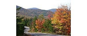
The refuge is situated along the rugged landscape of Choccolocco Mountain, one of the highest mountain ridges in Alabama. High elevation vistas (2063 feet ASL) provide an array of beautiful fall colors and breathtaking views of the surrounding region. Hardwood forests along mountain ridges contain species typical of the Blue Ridge Mountains to the north, while slopes and lower elevations are covered by longleaf pine and hardwoods commonly associated with the Coastal Plain.
The refuge was established on the former Fort McClellan military installation in 2003. Protection and management of old-growth and second-growth longleaf pine forests were the primary purposes for establishing the new refuge. Only in northwest Alabama and northeast Georgia do longleaf pine forests extend north of the Coastal Plain into the Appalachian Mountains. In recent years, this area has collectively become known as the Mountain Longleaf Pine Region.
A hundred years of army wildfires have maintained healthy longleaf pine forests over much of the refuge. Without recurring fire, these same forests have disappeared from much of the surrounding region. The refuge provides a unique laboratory for studying and understanding the natural composition of fire maintained second and old-growth longleaf pine forests.
Getting There . . .
Mountain Longleaf NWR is located in Calhoun County, Alabama adjacent to the City of Anniston. Visitors traveling along I-20 from Atlanta (east) can leave the Interstate at Exit 199 (Heflin), and travel 12 miles north on Highway 9 to the Joseph Springs Motorway. Turn left on the motorway at the “T” intersection with Choccolocco Road turn right and then immediately turn left onto Bain’s Gap Road to enter the refuge. Visitors traveling along I-20 from Birmingham (west) can leave the Interstate at Exit 185 (Oxford), and travel 12 miles north on Highway 21 to the former Fort McClellan military installation. Turn right into McClellan and follow the roadway to Bain’s Gap Road and the refuge.
Refuge headquarters is located within the former Fort McClellan cantonment area and provides information and brochures for the refuge.
Source: U.S. Fish & Wildlife Service