Walls Of Jericho
Walls of Jericho Forever Wild

The Walls of Jericho Trail System in located within the Forever Wild Walls of Jericho Tract in Jackson County, Alabama, near Hytop, Alabama, which consists of 12,510 acres bordering Tennessee. The tract is comprised of mountainous and wooded terrain, hosting caves, springs, rocky bluffs, steep canyon walls and portions of the headwaters of the Paint Rock River. The tract is part of the J.D Martin Skyline Wildlife Management Area, and is adjacent to the Post-Oak Flat Tract and the Henshaw-Cove Tract.
The land protected serves as a base for traditional forms of conservation related recreation, following the principles of multiple-use. Bird watching, backpacking, hiking, horseback riding, hunting, stream fishing and wildflower viewing are all accommodated on Alabama’s Walls of Jericho Tract. All of these activities are best assessed by improved public access parking areas along Hwy 79. There are separate parking areas for horseback riding access and hiking access.
Hiking Trails
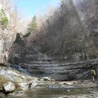
There are currently 3 hiking trails available. Both the Walls of Jericho Trail (6 miles round-trip) and the Bear Den Point Loop (4.7 miles round-trip) leave from the hiking trail parking lot. The South Rim Trail (1 mile round-trip) leaves from the Clark Cemetery Campsite located along the Walls of Jericho Trail. The Walls of Jericho Trail leads down through the box canyon known as the Walls of Jericho into the breath taking Limestone Cathedral.
Horseback Riding
A horseback riding trail (8.3 miles one-way) leads down to the Clark Cemetery Campsite. No horses are allowed beyond the Clark Cemetery Campsite, foot traffic only. Horses riders can tie up their horses at the campsite and hike the remaing 1/2 mile into the Walls of Jericho Canyon.
Primitive Camping
There are 3 primitive campsites available. One is located near the hiking trailhead parking lot and the second is located at Clark Cemetery in the valley. The third campsite is located in the horseback riding trailhead. Posted signs will direct you to the campsites. There is more information about Alabama campgrounds here.
For more information about Alabama Forever Wild Program visit the program web site.
Return to ALABAMA NATURE PRESERVE MAIN PAGE
Visitor Information
Date Opens: 1/1 – Date Closes: 12/31
Time Opens: Not Available – Time Closes: Not Available
None
Directions
Starting from the intersection of Highway 35 and Highway 72 located in Scottsboro, AL, take Highway 72 W towards Huntsville for 5 miles, Turn Right onto Highway 79. Follow Highway 79 N for 25 miles for the horseback riding trailhead and 26 miles for the Hiking Trailhead. Trailheads will be on the left side of the road.
Additional InformationWidth: 24 inches. Primary Surface: Soil, Compacted Secondary Surface: Crushed Rock Average Grade: 5% Elevation Low Point: 700 Elevation High Point: 1774 Year Designated: 2012 Date Last Updated: —
|
Contact InformationPublic Contact:
|