Bureau of Land Management Mining Claims
Bureau of Land Management Mining Claims MINING CLAIMS A mining claim is a parcel of land for which the claimant
Continue readingEXPLORE ALABAMA – For Adventure-Spirited Souls Looking for Something A Little Bit Different.
Information herein is based on publicly available data through the Bureau of Land Management. The author accepts no liability for the content of this data, or for the consequences of any actions taken on the basis of the information provided.
The author makes no warranty, expressed or implied, including the warranties of merchantability and fitness for a particular purpose, nor assumes any legal liability or responsibility for the accuracy, reliability, completeness or utility of these geospatial data, or for the improper or incorrect use of these geospatial data. These geospatial data and related maps or graphics are not legal documents and are not intended to be used as such. The data and maps may not be used to determine title, ownership, legal descriptions or boundaries, legal jurisdiction, or restrictions that may be in place on either public or private land. Natural hazards may or may not be depicted on the data and maps, and land users should exercise due caution. The data are dynamic and may change over time. The user is responsible to verify the limitations of the geospatial data and to use the data accordingly.
The gold belt of Alabama covers an area 60 miles wide and 100 miles long. Alabama Gold has been mined from both placer and lode sources. The gold belt enters and trends the northeastern part of the state coming from the border with Georgia towards an area in central Alabama, known as the Piedmont Uplift, fairly extensive and is approximately 100 miles long by 50-60 miles wide.
But the foremost strike of gold occurred in 1830 along the tributaries of Blue and Chestnut Creeks in Chilton County. This discovery made Alabama one of the prolific gold-producing states east of the Mississippi River, with almost 80,000 ounces of gold from 1830 to 1990.
Alabama gold mines offer prospecting, panning and treasure hunting.
Bureau of Land Management Mining Claims MINING CLAIMS A mining claim is a parcel of land for which the claimant
Continue reading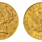
During the meeting reports reached Scottsboro that gold had also been discovered on the north side of the Tennessee river opposite the mouth of Santa Creek and the town became greatly excited. Land owners now refuse to entrain propositions of sale.
Continue readingGold in Calhoun County Alabama Jacksonville Alabama Gold Mines Arbacoochee Placer Mines Near Hefling Alabama The Arbacoochee Placer Mines are
Continue readingGold in Chambers County Alabama
Continue readingGold in Cherokee County Alabama
Continue reading
Gold was originally found in Alabama in the 1830’s around Chilton County, west of the Coosa River along Chestnut Creek and Blue Creek. Until WWII, the total recorded gold production reached around 50,000 troy ounces. Most of Alabama’s gold can be found in and around an area called the “Piedmont Upland” which includes the counties of Chilton, Clay, Cleburn, Coosa, Randolph, Talladega, and Tallapoosa.
Continue reading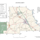
Great handpicked content collected from a variety of sources including online resources and historical documents. Professional research and consultation with experts brings together a wealth of information professionally edited for publication.
Continue readingGold in Coffee County Alabama
Continue reading
Clay County, Alabama has 166 records of mines listed by the United States Geological Survey (USGS). Placer gold is found in many streams in the county including Crooked Creek, Wesobulga Creek and the Tallapoosa River.
Continue reading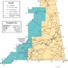
This Cleburne County Alabama Gold Mines information is for reference purposes only. You should never attempt to visit any sites listed without first ensuring that you have the permission of the land and/or mineral rights holders and that you are aware of all safety precautions necessary.
Continue readingCleburne County Gold In The News 1891 ALABAMA GOLD – A Rich Mine Found in Cleburne County A recent issue of
Continue readingGold in Elmore County Alabama Gold Branch Coordinates: 32.651798°N, -85.9502392°W Gold in Lee County Alabama Crumpton Gold Prospect The Crumpton
Continue readingGold in Etowah County Alabama Duncan Prospect Private Gold RETURN TO TABLE OF CONTENTS
Continue readingGold in Coosa County Alabama A belt of light green colored, highly pyritiferous, altered eruptive rock occurs paralleling the “Talladega”
Continue readingGold in Lee County Alabama Lee County Alabama Gold Mines Ballinger Prospect Gold Crumpton Prospect Gold Crutchfield Mine Underground Gold
Continue reading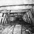
Area streams and branches near Wedowee are most productive. Placer gold is found in the local watercourses, beach sands and gravels.
Continue readingGold in St. Clair County Alabama Hatchet Creek Placer Gold Hatchet Creek Placer Gold RETURN TO TABLE OF CONTENTS
Continue readingGold in Talladega County Alabama
Continue readingTHE GOLD LOG MINE, TALLADEGA COUNTY, ALABAMA. By EDSON S. BSASTIN. Source: McCaskey, H. D.. Notes on some gold
Continue reading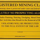
This “Devil’s Back-bone” ridge crosses the Tallapoosa river in Sec. 32, T 21, R.22, and preserving its general characteristics in a north-easterly course, crosses the Columbus and Western Railroad at Jackson’s Gap Station; and again crosses the Tallapoosa river near the northern borders of the Horse Shoen ;bend in which is locate the old battle ground where Gen. Jackson roiuthed the Indians.
Continue readingTallapoosa County Alabama Gold Map Tallapoosa County composed four principal gold districts: Goldville The Goldville Mining District had a number
Continue reading