Bullock County Alabama History by Smith and DeLand
Bullock County Alabama History by Smith and DeLand
Source: Northern Alabama – Historical and Biographical by Smith & De Land, Birmingham, Ala 1888
Population: White 6,800; colored 21,486; Area 660 square miles. Woodland all, except a few square miles of prairie. Prairie region, 300 square miles (200 of black prairie etc. and 109 hill prairie, or Chunnenugga Ridge). Oak and hickory uplands, with long-leaf pine, 360 square miles.
Acres in cotton (approximately), 80,470; in corn 47,441; in oats 6,177; in wheat 111; in rye 88; in sugar-cane 429; in rice 16; in sweet potatoes 773. Approximate number of bales of cotton, in round numbers 22,000.
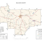
County Seat – Union Springs; population 2,200; situated near the center of the county.
Newspapers published at County Seat – Bullock County Reporter and Herald (both Democratic).
Post offices in the County – Aberfoil, Arbor Vitae, Bughall, Enon, Fitzpatrick’s, Flora, Guerrytown, Hector, Indian Creek, Inverness, James, Midway, Mitchell’s Station, Mount Hilliard, Perote, Pine Grove, Postoak, Shopton, Strawberry, Suspension, Thompson, Three Notch, Union Springs.
Bullock County, situated in what is known as the Black Belt of Alabama, was formed in 1880 out of parts of the adjacent counties of Macon, Russell, Barbour, Pike and Montgomery.

It took its name from the late Edward C. Bullock, of Barbour County.
The tax valuation of its property in 1887 was about $3,500,000, with rate for the county of four mills, which is sufficient for current expenses, the county being out of debt.
The county is divided into two nearly equal parts by Chunnenugga Ridge, which extends quite through it from the northeast to the southwest.
That portion north and west of the Ridge is known as the prairie district. It is from 100 to 150 feet lower than the ridge, and is for the most part level but sufficiently undulating for thorough drainage. These lands are chiefly what are known as black and post oak prairie, being of calcareous formation, interspersed in many places with phosphatic nodules, and are very rich. They are best adapted to cotton and corn, which constitute the chief crop, though small grain, potatoes. sugar-cane, and all varieties of vegetables and many fruits grow quite as well.
From a third to half a bale of cotton and twelve to fifteen bushels of corn to the acre, are regarded as about the average yield. Fully one-half of the tillable lands are devoted to cotton. These lands range in price from five to ten dollars per acre, depending upon the amount and character of the improvements.
That portion of the county south of the Ridge is of drift formation, and constitutes what are called the uplands. It is generally elevated, having very nearly the altitude of the Ridge, sloping gently, however, toward the south. This region is composed mostly of what is known as oak and hickory lands, sandy with clay subsoil. They are abundantly watered, and in the main thoroughly well drained, naturally. The head waters of Pea and Conecuh Rivers are in this county; besides there are important tributaries of the Chattahoochee in the eastern, and Tallapoosa River in the western and northern parts of the county.
The lands in the southern part of the county, though less rich than the prairie region, yield, with moderate fertilization, abundant crops of corn and cotton, and in their capacity for vegetables and all kinds of fruits are probably unexcelled in the South. Stock-raising is but recently beginning to receive attention, and promises from the favorable soil and climate for the production of grasses, to equal any of the more favored portions of the State.
———
Manufacturing has hitherto received no very special attention, the county being preeminently an agricultural one, though it is believed that, situated centrally in the cotton belt as it is, the manufacture of this staple might be made very profitable. The altitude at Union Springs is 519f feet above sea-level, being perhaps the highest point on this parallel of latitude anywhere between the Atlantic Ocean and Rocky Mountains. This extraordinary altitude is thought to protect it in some degree from excessive rain-fall, the average from a correctly kept record of seventeen years being only forty-eight inches annually, which was distributed tolerably nearly equally through the four seasons of the year. The southwest winds are most frequently the ones that attend the rains, though seasons of somewhat continuous rains are chiefly brought by the southeast winds.
Gentle breezes from the south Gulf region are very common during the summer months of June and July, setting in late in the afternoon and continuing until midnight, generally rendering the nights sufficiently comfortable for refreshing sleep.
The summer heat, which occurs chiefly in June and July, rarely ascends higher than 90′ nor is this height maintained for very many days. Exceptionally it reaches 94’or 96′, but these periods are of short duration, usually not more than a day or two, before they are broken by refreshing showers.
From carefully kept vital and mortuary statistics, regulated by law, it appears that the white death rate from all causes, per 1,000 of population in 1886, was 11.47, and in 1887 the rate was 10.73 per l,000.
The prevailing diseases, gleaned from the same source, are malarial fever, dysentery and pneumonia. Among the colored people there is considerable consumption, due probably to their want of proper regard for personal hygiene, but the death rate from this cause in 1887, in the county, was only 1.1 per l,000 of population among the whites. Indeed, consumption, many of its forms, is a very rare disease among the whites in this part of the State. In most cases it yields to proper treatment, and, it is known, to our physicians, that many cases, contracted in the North, get well by a kind of self-limitation when moved to the southern part of Alabama.
Union Springs, the county seat, is situated near the center of the county, on Chunnenuggee Ridge, overlooking the immense prairie district to the north, and at the crossing of the Mobile & Girard with the Montgomery & Eufaula Railroads. It has a population of about 2,500. It is beautifully laid off and shaded with numerous oaks and elms. It has several splendid buildings, among which may be mentioned the court house, which cost about $60,000, and in point of magnificence is second only to the best in the State.
There are four churches, namely, Presbyterian, Methodist. Baptist and Episcopalian. There are two very fine schools in successful operation. The Union Springs Female College, chartered by the Legislature in 1866, Prof. H. K. W. Smith, President, with a full corps of teachers, and the Union Springs Seminary, presided over by Prof. J. R. Smith. There is also a street railroad owned by a corporation of the town.
Surrounded by one of the finest agricultural districts of the State, Union Springs has few superiors in a business point of view. Her merchants are thrifty, and many of them in very easy circumstances – a wealth that has for the most part been accumulated by a legitimate business confined to the immediate vicinity.
Midway, the next largest town in the county, with a population of about 500, is situated on the Montgomery & Eufaula Railroad, twelve miles Southeast of Union Springs. It is noted for its refined society, its excellent schools, the thrift of its merchants and the fertile quality of its agricultural lands.
Enon, Guerryton, Perote, Inverness, Thompson’s and Fitzpatrick’s are the other smaller towns.
For more information on Bullock County, visit the Bullock County Alabama home page.