Map: Georgia & Alabama Post Offices, Post Roads, Canals, Rail Roads
1839 map of Alabama and Georgia showing post offices, post roads, canals, railroads, etc
Continue readingBooks About Alabama
1839 map of Alabama and Georgia showing post offices, post roads, canals, railroads, etc
Continue reading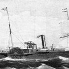
One of the oldest cities in the United States, Mobile is the seat of Mobile County in the southwestern corner of Alabama along Interstate Highway 10, on the banks of the Mobile River.
As a port city, its influences were shaped by the varied cargoes and exotic travelers that constantly passed through.
Continue reading
Manuscript Map of Southwestern Jefferson County, Unpublished, c.1888; for the Louisville and Nashville Railroad
Continue readingTitle
Map of Alabama.
Summary
Shows drainage, township and county boundaries, cities and towns, and the railroad network in colored lines.
Contributor Names
Alabama. Railroad Commissioners.
Created / Published
Chicago, 1888.
Subject Headings
– Railroads–Alabama–Maps
– United States–Alabama
Notes
– Scale ca. 1:1,150,000.
– “Prepared expressly for the Tenth (10th) Annual report of the Railroad Commissioners of Alabama.”
– LC Railroad maps, 179
– Description derived from published bibliography.
– Available also through the Library of Congress Web site as a raster image.
Description
Shows drainage, township and county boundaries, cities and towns, and the railroad network in colored lines.