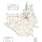
DALLAS COUNTY ALABAMA
Dallas County Alabama

Dallas County population is 43,820. The county seat is Selma. Its name is in honor of United States Secretary of the Treasury Alexander J. Dallas, who served 1814-1816.
The county is traversed by the Alabama River and bordered by Perry, Chilton, Autauga, Lowndes, Wilcox, and Marengo counties. Originally, the Dallas county seat was at Cahaba, which also served as the state capital for a brief period. In 1865, the county seat was transferred to Selma. Other towns and communities in the still mostly rural county include Marion Junction, Sardis, Orrville, Valley Grande, and Minter.
Dallas County Alabama Cities
Selma Alabama
Valley Grande Alabama
Valley Grande is a city in Dallas County, just north of Selma.Valley Grande encompasses the historic community of Summerfield. Established in 1819 as “Valley Creek”, the town was renamed “Summerfield” in 1845 to honor the noted Methodist preacher John Summerfield.
Dallas County Alabama Towns:
Orrville Alabama
Orrville is a town in Dallas County. At the 2010 census the population was 204. Orrville Farmers Market opened in 2016 in the heart of town and sells locally grown farm-fresh produce, artisan foods, agricultural-based products and country-themed gifts. The market also serves hot breakfast and lunch six days a week, Monday through Saturday. Orrville Farmers Market gives local farmers the opportunity to develop a personal relationship with their customers and to cultivate consumer loyalty to the farmer who grows the produce and produces farm-fresh products.
Dallas County Alabama Communities:
Beloit Alabama
Beloit is an unincorporated community in Dallas County.
Bogue Chitto Alabama
Bogue Chitto is an unincorporated community in Dallas County. It was named for the nearby creek of the same name, which in the Choctaw language means “big stream.”
Browns Alabama
Browns is an unincorporated community in Dallas County.
Carlowville Alabama
Carlowville is an unincorporated community in Dallas County. A portion of Carlowville was designated as the Carlowville Historic District on the National Register of Historic Places on January 18, 1978, the Carlowville Historic District. Carlowville was listed on the 1880 U.S. Census as an unincorporated community with a population of 154. It has not been listed on the census since, though the census division of Dallas County it is located within still bears that name to date.
Crumptonia Alabama
 Crumptonia, Alabama is an unincorporated community in Dallas County. It is named for a local plantation house of the same name, built in 1855 by Claudius M. Cochran and later owned by the Crumpton family.
Elm Bluff Alabama
Elm Bluff, also known as Centreport, Shepardsville, and Shepardville, is an unincorporated community in Dallas County. It was named for the nearby bluff on the Alabama River and the closely associated Elm Bluff Plantation.
Marion Junction Alabama
Marion Junction, also known as Bridges, is an unincorporated community in Dallas County.
Massillon Alabama
Massillon is a populated place located in Dallas County.
Minter Alabama
Minter is an unincorporated community in Dallas County. Minter has one site included on the National Register of Historic Places, the Street Manual Training School.
Plantersville Alabama
Plantersville is an unincorporated community in Dallas County. It lies near the county’s border with Autauga and Chilton counties. Plantersville was named for the local cotton planters and plantations. The original name of the town was Corinth. The post office was established in 1867.
After the Civil War Battle of Ebenezer Church (April 1, 1865), Union troops burned the railroad depot at Plantersville and a cotton warehouse. Maj. Gen. James H. Wilson’s troops spent the night camped in Plantersville, then on to the Battle of Selma the next day.
History of Plantersville
The community now known as Plantersville was first called Corinth. It was located on the banks of Big Mulberry Creek, on an Indian trail leading from Huntsville to Cahaba.
Pleasant Hill Alabama
Pleasant Hill is an unincorporated community in Dallas County. The community began as a trading post called Fort Rascal prior to the Indian removal. It gained a post office in 1828 and the name was changed to Pleasant Hill. Pleasant Hill has one site included on the National Register of Historic Places, the Pleasant Hill Presbyterian Church. It has several sites listed on the Alabama Register of Landmarks and Heritage and one nearby, Belvoir.
Richmond Alabama
Richmond, also known as Warrenton, is an unincorporated community in Dallas County. Richmond has one site included on the National Register of Historic Places, the Street Manual Training School. Elm Bluff Plantation, owned by John Jay Crocheron, is nearby in Elm Bluff.
Safford Alabama
Safford is an unincorporated community in Dallas County.
Sardis Alabama
Sardis, also known as Berlin, is an unincorporated community in Dallas County.
Selmont-West Alabama
Selmont-West Selmont is located in eastern Dallas County. It is on the south side of the Alabama River, which separates it from the city of the Selma, the county seat, to the north. The Edmund Pettus Bridge carries U.S. Route 80 across the river into Selma at the north end of Selmont-West.
Selmont Alabama
Summerfield Alabama
Summerfield, also known as Valley Creek, is an unincorporated community in Dallas County. Most of the community was annexed into Valley Grande following its incorporation as a city in 2003.
Tyler Alabama
Tyler is an unincorporated community in Dallas County.
If you would like to become a sponsor, advertise a related location, service or vacation spot that would add to the usefulness of this site, please email us: staff@digitalalabama.com.
Dallas County Alabama Ghost Towns
Blalock Alabama
Latitude N32 18.560′ Longitude W87 23.015′
32°18’33.6″N 87°23’00.9″W
32.309333, -87.383583
Cahaba Alabama
Latitude N32 19.0151 Longitude W87 06.080′
32°19’00.9″N 87°06’04.8″W
32.316918, -87.101333
Casey Alabama
Latitude N3219.7611 Longitude W86 56.601′
32°19’45.7″N 86°56’36.1″W
32.329352, -86.943350
Crumptonia Alabama
Latitude N32 12.832′ Longitude W87 17.360′
32°12’49.9″N 87°17’21.6″W
32.213867, -87.289333
Donald Alabama
Latitude N32 14.956′ Longitude W87 23.643′
32°14’57.4″N 87°23’38.6″W
32.249267, -87.394050
Harrell Alabama
Latitude N32 26.587′ Longitude W87 12.935′
32°26’35.2″N 87°12’56.1″W
32.443117, -87.215583
Kings Landing Alabama
Latitude N32 15.352′ Longitude W87 04.924′
32°15’21.1″N 87°04’55.4″W
32.255867, -87.082067
Massillon Alabama
Latitude N32 26.279′ Longitude W87 17.754′
32°26’16.7″N 87°17’45.2″W
32.437983, -87.295900
Minter Alabama
Latitude N32 04.674′ Longitude W86 59.617′
32°04’40.4″N 86°59’37.0″W
32.077900, -86.993617
Moro Alabama
Latitude N32 39.639′ Longitude W87 01.203′
32°39’38.3″N 87°01’12.2″W
32.660650, -87.020050
Pleasant Hill Station Alabama
Latitude N32 09.640′ Longitude W86 54.852′
32°09’38.4″N 86°54’51.1″W
32.160667, -86.914200
Portland Alabama
Latitude N32 09.273′ Longitude W87 10.121′
32°09’16.4″N 87°10’07.3″W
32.154550, -87.168683
Potter Alabama
Latitude N32 25.869′ Longitude W87 06.489′
32°25’52.1″N 87°06’29.3″W
32.431150, -87.108150
Soapstone Alabama
Latitude N32 14.679′ Longitude W86 52.413′
32°14’40.7″N 86°52’24.8″W
32.244650, -86.873550
Tasso Alabama
Latitude N32 13.037′ Longitude W87 11.793′
32°13’02.2″N 87°11’47.6″W
32.217283, -87.196550
Tilden Alabama
Latitude N32 03.955′ Longitude W87 08.587′
32°03’57.3″N 87°08’35.2″W
32.065917, -87.143117
Tyler Alabama
Latitude N32 20.363′ Longitude W86 52.782′
32°20’21.8″N 86°52’46.9″W
32.339383, -86.879700
Dallas County Alabama Historic Destinations
Adams Grove Presbyterian Church
Wooden-framed Presbyterian church, built in the Greek Revival style in 1853. Southern side of Cahaba-Greenville Rd.
32°16′20″N 87°01′51″W , 32.272222, -87.030833
Dallas County Courthouse
The Joseph T. Smitherman Historic Building, also known by a variety of other names throughout its history, is a historic Greek Revival building in Selma, Alabama. Completed in 1847, it has served many functions in the more than 160 years of its existence. The building was added to the National Register of Historic Places on June 20, 1975, due to its architectural and historical significance. It currently houses the Vaughan-Smitherman Museum, a museum depicting Selma’s history.
109 Union St.
32°24′18″N 87°01′33″W , 32.405, -87.025833
Driskell-Martin House
32°39′36″N86°55′26″W, 32.66, -86.923889
The Driskell–Martin House is a historic house in Plantersville, Dallas County, Alabama. It is the oldest surviving high style residence in the community. The two-story wood-frame house was built for Thomas Sanford Driskell, a planter and a merchant from Virginia, in 1850. The builders were Nelson Mitchell and Massena Godwin. The house was used as a Union headquarters during the American Civil War. Their forces occupied it during Wilson’s Raid through Alabama in April 1865. The house remained in the Driskell family until purchased by Dr. Thomas Munroe Martin in 1915.
Edmund Pettus Bridge – Selma
Kenan’s Mill – Orrville
Old Cahawba Archaeological Park – Selma
Ancient Africa, Enslavement, and Civil War Museum – Selma
National Voting Rights Museum and Institute – Selma
Old Depot Museum – Selma
Selma Interpretive Center – Selma
First Baptist Church – Selma
Brown Chapel African Methodist Episcopal Church – Selma
410 Martin Luther King, Jr. St.
32°24′45″N 87°00′58″W, 32.4125, -87.016111
Brick African Methodist Episcopal church, built in 1908. Known for its association with the Civil Rights Movement and Selma to Montgomery marches.
One thought on “DALLAS COUNTY ALABAMA”
Comments are closed.