Louina Alabama
Louina Alabama

Louina Alabama, sometimes called Ole Louina, is a ghost town located 14 miles west of Roanoke Alabama and about one mile east of Wadley Alabama in Randolph County, Alabama.
Louina Alabama Native American Tribes
The story that has been passed through generations goes that the town was originally settled by Creek Indians defeated in the Battle of Horse Shoe Bend by Andrew Jackson. Louina is named for an Indian woman who ran a trading post some years after it was taken over.Louina was settled by the Indians, pushed to Alabama by the white settlers from the overcrowded east during the 1830s. The town was named for an Indian woman, the wife of an Indian Chief named Nicahargo, who operated a successful trading post which quickly became the metropolis of its day and section.
Ole Louina was a community during early settlement of Randolph County which was settled after the Battle of Horseshoe Bend in 1814 when the Creek Indians were defeated by General Andrew Jackson. The town of Louina was “one mile North, on the East bank of Tallapoosa River. It was settled in 1834. Paul Richardson, The Lafayette Sun, writes “In the early days, Louina and had a ferry, so a stage line soon developed between Wedowee Alabama and Dadeville Alabama. Once the stage line started operating, a community evolved around the river crossing.”
Louina Alabama History
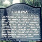
Louina became a chief business center in Randolph County with the county’s first newspaper, schools for boys and girls, Baptist and Methodist Churches, Masonic Lodge, grist mill, wool factory, and cotton gin. The Concord Baptist church was organized in 1850 by J. Day Barron, editor of the Louina Eagle, the towns newspaper. Louina was on the stage coach line from Wedowee to Dadeville. In 1856 the newspaper was moved to Wedowee and the name was changed to the Southern Mercury, later it was changed to the Randolph County Democrat. The paper closed just before the Civil War.
The town was founded in 1834 and lasted until about 1905, and at one time was largest town in Randolph County with two churches, several stores, and a gristmill.
One of the county’s first post offices was in Louina. The town continued to prosper on a limited basis after the Civil War, but its decline began in 1870.
Louina Alabama Gold and Silver
According to tradition and folklore, the Louina area coughed up gold and silver.
The Lost Treasure of Louina
When Louina, the wealthy Indian woman, was forced to leave on the Trail of Tears, it was said she put all her silver in sacks but they were so heavy, the ponies could not carry the load. Legend has it that Louina buried some silver but, despite years of digging, none has been found. During the Indian Relocation Act, it is said, Louina was among the Native Americans forced to leave. The tale goes on to say that she buried silver and gold in Louina before she left, but not before putting a curse on the town, swearing that it would cease to exist. Over time, the very prosperous town began a downward spiral until it vanished along with most of its history.
It is said, by many locals, that the town that once had 2,500 residents and was the largest town in Randolph County. The area has only 17 wells filled, which means many old wells may still be open, making the area potentially dangerous. People are warned not to go hunting, or digging for the silver alone.
Louina Alabama Today
Louina is a popular spot for archaeology students to look for the remains of the city (and maybe the purported treasure). The descendants of the foundling settlers of the city are currently working to preserve the site.
If you are interested in additional Alabama ghost articles, be sure to take a look at the Alabama Ghost Main Page.
View More at the Alabama Ghost Towns Index
Coordinates: 33°07′28″N 85°33′08″W
