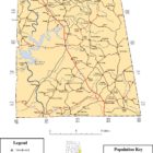
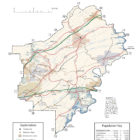
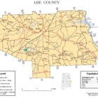
Category: Alabama Counties

Alabama Counties

Alabama has sixty-seven counties. The oldest is Washington County (created June 4, 1800) and the youngest is Houston County (created February 9, 1903).

Alabama was claimed by Spain, as Spanish Florida, and by England, as the Province of Carolina. The first permanent colony was made by the French on the banks of the Mobile River in 1702.

After the American Revolutionary War, West Florida south of the 31st parallel became a part of Spain while most of the rest was put in the Mississippi Territory. The territorial assembly established some of the earliest county divisions which have survived to the present. In 1817 the western part of the territory became the State of Mississippi and the remainder the Alabama Territory. The Alabama territorial legislature made some more counties.

Alabama became the 22nd state of the United States in 1819. The Alabama state legislature made more counties from former Indian lands as the Indian Removal Act took effect and settlers populated different areas of Alabama.

In 1820, Alabama had 29 counties. By 1830 there were 36, with Indians still occupying land in northeast and far western Alabama. By 1840, 49 counties had been created; 52 by 1850; 65 by 1870; and the present 67 counties by 1903.

According to 2006 U. S. Census estimates, the average population of Alabama’s sixty-seven counties is 68,642, with Jefferson County has the most people (656,700), and Greene County (9,374) the least. The average land area is 757 sq mi (1,960.6 km2). The largest county is Baldwin (1,596 sq mi (4,133.6 km2)) and the smallest is Etowah (535 sq mi (1,385.6 km2)).

Alabama Counties Created From Native American Lands

Alabama was admitted as the 22nd state in 1819. The Alabama legislature formed additional counties from former native lands as the Indian Removal Act took effect and settlers populated different areas of Alabama. In 1820, Alabama had 29 counties. Native Americans still occupied large areas of land in northeast and far western Alabama. By 1840, 49 counties had been created; 52 by 1850; 65 by 1870; and the present 67 counties by 1903. Houston County was the last county created on February 9, 1903. The average area is 805 sq mi. The smallest is Etowah.

Lee County Alabama Map

LEE COUNTY ALABAMA

Eplore Alabama: Lee County is a county located in east central Alabama. As of the 2010 census the population was 140,247. The county seat is Opelika, and the largest city is Auburn. The county is named for General Robert E. Lee (1807–1870), who served as General in Chief of the Armies of the Confederate States in 1865. Lee County comprises the Auburn-Opelika, AL Metropolitan Statistical Area, which is included in the Columbus-Auburn-Opelika, GA-AL Combined Statistical Area.

Continue reading
Lowndes County Alabama Map

LOWNDES COUNTY ALABAMA

Lowndes County was formed from Montgomery, Dallas and Butler counties, by an act of the Alabama General Assembly on January 20, 1830. The county is named for South Carolina statesman William Lowndes. It is part of the Black Belt, where cotton plantations were developed in the antebellum years and agriculture continued as a dominant part of the economy into the 20th century.

Continue reading

Marion County Alabama

Marion County Alabama offers a range of recreational activities. The Sam R. Murphy Wildlife Management Area consists of 25,150 acres of game hunting. The Upper Bear Creek Reservoir and the Marion County Public Fishing Lake offer boating, canoeing, kayaking, fishing, and birdwatching. Twin Forks Park, near the Bear Creek Reservoir, includes picnic and campsite areas as well.

Continue reading
Marshall County Alabama Map

MARSHALL COUNTY ALABAMA

Cherokees settled along the Creek Path and the Tennessee River as early as 1784 inhabiting the area. Most of the remains of these towns and villages can be identified. During The War Between the States, Marshall County was the scene of several raids by Federal troops. It was unsuccessfully shelled by these troops on July 30, 1862 in an attempt to capture the town. It was again attacked on March 2, 1864, and again on August 24, 1864. It finally yielded to the invaders January 1865, and was burned and destroyed with the exception of six or seven buildings.

Continue reading
Monroe County Alabama Map

MONROE COUNTY ALABAMA

Explore Alabama – Monroe County Alabama: Beatrice Alabama, Excel Alabama, Frisco City Alabama, Vredenburg Alabama, Megargel Alabama, Peterman Alabama, Uriah Alabama, Buena Vista Alabama, Burnt Corn Alabama, Finchburg Alabama, Franklin Alabama, Goodway Alabama, Manistee Alabama, Mexia Alabama, Natchez Alabama, Old Salem Alabama, Old Texas Alabama, Perdue Hill Alabama, River Ridge Alabama, Scratch Ankle Alabama, Tunnel Springs Alabama, Wainwright Alabama

Continue reading

PICKENS COUNTY ALABAMA

Explore Alabama – Pickens County Alabama: Aliceville Alabama, battleship memorial park and museum, Beards Mill Alabama, Benevola Alabama, carrollton alabama, Coal Fire Alabama, Cochrane Alabama, Dancy Alabama, Ethelsville Alabama, Gordo Alabama, Lubbub Alabama, Macedonia Alabama, McMuillen Alabama, McShan Alabama, museums in alabama, Olney Alabama, Palmetto Alabama, Pickensville Alabama, Reform Alabama, Sapps Alabama, vienna alabama, Zion Alabama

Continue reading

RANDOLPH COUNTY ALABAMA

Located in the heart of East Central Alabama, Randolph County sits upon a myriad of natural beauty, historic sites, with economic and entrepreneurial opportunities. Strategically located between Birmingham and Atlanta, our four towns, Roanoke, Wadley, Wedowee and Woodland, each with their own character and charm, offer an array of economic and entrepreneurial opportunities.

Continue reading
error: .