Category: Alabama Counties

Alabama Counties

Alabama has sixty-seven counties. The oldest is Washington County (created June 4, 1800) and the youngest is Houston County (created February 9, 1903).

Alabama was claimed by Spain, as Spanish Florida, and by England, as the Province of Carolina. The first permanent colony was made by the French on the banks of the Mobile River in 1702.

After the American Revolutionary War, West Florida south of the 31st parallel became a part of Spain while most of the rest was put in the Mississippi Territory. The territorial assembly established some of the earliest county divisions which have survived to the present. In 1817 the western part of the territory became the State of Mississippi and the remainder the Alabama Territory. The Alabama territorial legislature made some more counties.

Alabama became the 22nd state of the United States in 1819. The Alabama state legislature made more counties from former Indian lands as the Indian Removal Act took effect and settlers populated different areas of Alabama.

In 1820, Alabama had 29 counties. By 1830 there were 36, with Indians still occupying land in northeast and far western Alabama. By 1840, 49 counties had been created; 52 by 1850; 65 by 1870; and the present 67 counties by 1903.

According to 2006 U. S. Census estimates, the average population of Alabama’s sixty-seven counties is 68,642, with Jefferson County has the most people (656,700), and Greene County (9,374) the least. The average land area is 757 sq mi (1,960.6 km2). The largest county is Baldwin (1,596 sq mi (4,133.6 km2)) and the smallest is Etowah (535 sq mi (1,385.6 km2)).

Alabama Counties Created From Native American Lands

Alabama was admitted as the 22nd state in 1819. The Alabama legislature formed additional counties from former native lands as the Indian Removal Act took effect and settlers populated different areas of Alabama. In 1820, Alabama had 29 counties. Native Americans still occupied large areas of land in northeast and far western Alabama. By 1840, 49 counties had been created; 52 by 1850; 65 by 1870; and the present 67 counties by 1903. Houston County was the last county created on February 9, 1903. The average area is 805 sq mi. The smallest is Etowah.

Covington County Alabama Map

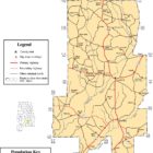
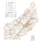
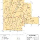
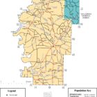
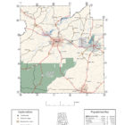
COVINGTON COUNTY ALABAMA

The Conecuh National Forest, established in 1935, covers a large portion of the southwestern corner of the county. The Conecuh River runs through the western area of the county, and its tributary, Patsaliga Creek, runs through the northwestern section.
Every year the town of Opp stages Oppfest, an arts and antiques festival held during the last weekend of October.

Continue reading
DeKalb County Alabama Map

DEKALB COUNTY ALABAMA

DeKalb County was once a part of the territory occupied by the Cherokee Indian nation. The coming of white men to the county occurred during the American Revolution when a British agent, Alexander Campbell, was sent here for the purpose of arousing the Cherokees against the southern colonies. In 1777, Campbell made his headquarters at Wills Town, a Cherokee Indian village located on Big Wills Creek near the present community of Lebanon. Campbell was successful in arousing a number of the Cherokees by promising them clothing and conquered territory in exchange for the scalps of white settlers.

Continue reading
Houston-County-Alabama

HOUSTON COUNTY ALABAMA

Explore Alabama – Houston County Alabama: Dothan Alabama, Ashford Alabama, Avon Alabama, Columbia Alabama, Cottonwood Alabama, Cowarts Alabama, Gordan Alabama, Kinsey Alabama, Madrid Alabama, Rehobeth Alabama, Taylor Alabama, Webb Alabama, Ardilla Alabama, Barber Alabama, Big Creek Alabama, Brannon Stand Alabama, Crosby Alabama, Dupree Alabama, Enon Alabama, Garretts Crossroads Alabama, Grangeburg Alabama, Harmon Alabama, Hodgesville Alabama, Keytons Alabama, Love Hill Alabama, Luch Alabama, Merritts Crossroads Alabama, Pansey Alabama, Peterman Alabama, Pleasant Plains Alabama, Smyrna Alabama, Southern Junction Alabama, Terry Crossroads Alabama, Wilson Quarters Alabama

Continue reading
Jefferson County Alabama Map

JEFFERSON COUNTY ALABAMA

Jefferson county is located in the north-central portion of the state, on the southernmost edge of the Appalachian Mountains. It is in the center of the (former) iron, coal, and limestone mining belt of the Southern United States.

Jefferson County is the most populous county in the state of Alabama. As of the 2010 census, its population was 658,466. Its county seat is Birmingham, which is the most populous city in the state.

Continue reading
error: .